NOTICE OF MEETING
Notice is hereby
given, in accordance with the provisions of the Local Government Act 1993 that
a Meeting of Singleton Council will
be held in the Council Chambers, Queen Street
Singleton, on Monday 2 February 2009,
commencing at 5:30 pm.
EMERGENCY EVACUATION FOR COUNCIL MEETINGS HELD IN
THE COUNCIL CHAMBERS
In case of an emergency, for example a fire, please
evacuate the building via the marked exit doors (Mayor points to the doors).
The order to evacuate may be signified by an alarm siren or by a Council
officer or myself. Please proceed to the
green “emergency assembly area” signs either near the cycleway on Queen Street
(Mayor points in direction of Queen Street)
or at the other side of the carpark towards the Gym & Swim (Mayor points again). An instruction to evacuate to a marked area
shoud be followed without delay to assist Council in ensuring the Health and
Safety of all staff and visitors.
AGENDA PAGE
Apologies
Confirmation of Minutes
1. 01/12/2008
Mayoral Minute
Disclosures
and Declarations of Interest
Withdrawal
of Items and Late Items of Business
Presentations
Public
Access Session
Director Operations
Report No. 2/09
1. Waste
Conference 2009
Manager Community
Services Report No. 1/09
1. Community
Grants
2. Cultural
Development Advisory Committee
3. Colleen
Gale Children's Services
4. Youth
Programs
5. Community
Development November 2008 - January 2009
6. Singleton
Disability Advisory Committee Meeting
Manager
Parks
and Facilities Report No. 1/09
1. Singleton
Lions Club - Expo Site Electrical Power Boxes
Manager Water and
Waste Report No. 1/09
1. Water
and Sewer Reports - 01/11/2008 - 31/12/2008
2. Water
Reform - Inquiry into Secure and Sustainable Urban Water Supply and Sewerage
Services for Non-Metropolitan NSW
Manager Design and
Contracts No. 1/09
1. Design
& Contracts Program Area - Jobs in Progress
2. Acquisition
of part of Lot 5 DP 263134 for road widening - Glendonbrook Road
Manager Works Report
No. 3/09
1. Bitumen
Resealing Program
2. Works
Program Area Maintenance and Construction
3. Minutes
of the Local Traffic Committee Meeting - 27 November 2008
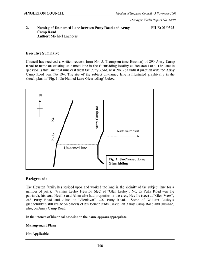
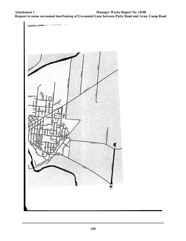
4. Naming
of Un-named Lane between Putty
Road and Army
Camp Road to Heuston Lane
Questions
Without Notice in Writing

ACTING
GENERAL MANAGER
Singleton
Council’s Vision Statement is:
“Singleton. A progressive community of excellence and
sustainability”
Singleton
Council’s Mission Statement is:
“To provide quality services to the community in an
efficient and friendly manner encouraging responsible development”
Singleton
Council’s Core Values are:
|
|
Value
|
Definition
|
|
·
|
Service
|
Putting the needs of customers first and achieving
excellence in customer service;
|
|
·
|
Consistency
|
Having a professional approach to work with the
highest ethical standards and a businesslike manner across the organisation;
|
|
·
|
Focus
|
Maintaining a clear focus on the vision and agreed
goals;
|
|
·
|
Respect
|
Earning and retaining the respect of the community;
|
|
·
|
Pride
|
General pride in works and services;
|
|
·
|
Communication
|
Excellence in communications;
|
|
·
|
Achievement
|
Developing a well trained, motivated and focussed
staff and elected Council;
|
|
·
|
Equity
|
Being a fair and equitable employer and provider of
services;
|
|
·
|
Reliance
|
Ensuring that the community, elected Council and
staff can rely upon each other;
|
|
·
|
Commitment
|
Displaying commitment and cohesion between
community, elected members and staff;
|
|
·
|
Efficiency
|
Services provided by the organisation are to be
carried out with the efficient allocation of resources;
|
COUNCIL POLICY
Council adopted a Code of Conduct
which provides details of statutory
requirements and gives guidance in respect of the way in which pecuniary and
conflict of interest issues should be approached.
Generally, the policies refer to the
following issues:
1. Councillors
are under an obligation at law to disclose any interest they may have in any matter
before the Council and to refrain from being involved in any consideration or
to vote on any such matter.
2. Councillors
must disclose any interest in any matter noted in the business paper prior to
or at the opening of the meeting.
3. The
nature of the interest shall be included in the notification.
4. Councillors
shall immediately and during the meeting disclose any interest in respect of
any matter arising during the meeting which is not referred to in the business
paper.
5. All
declarations of interest shall be recorded by the General Manager.
6. All
disclosures of interest shall as far as is practicable be given in writing.
7. Any
member having an interest shall leave the meeting and remain absent while the
subject of the interest is being considered by Council.
8. The
meeting shall not discuss any matter in which a councillor has an interest
while the councillor is present at the meeting.
|
SINGLETON COUNCIL
|
Meeting of Singleton Council - 2 February 2009
|
|
|
|
|
|
Director
Operations Report No. 2/09
|
|
|
|
|
1.
|
Waste
Conference 2009
Author: Leisa Parsons
|
FILE: 09/0008
|
|
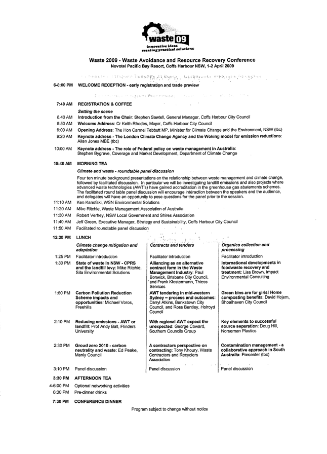
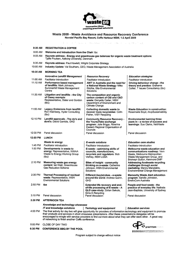
Executive Summary:
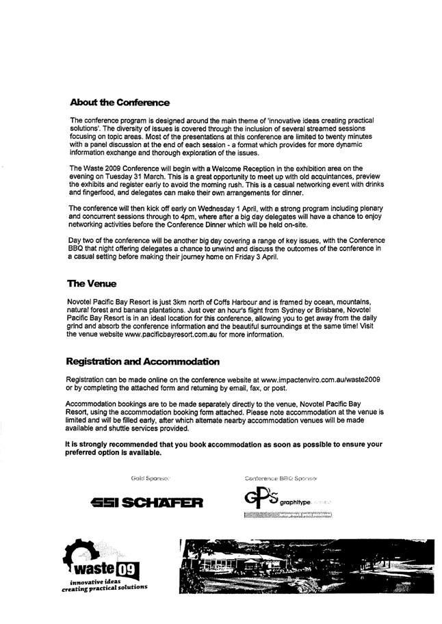
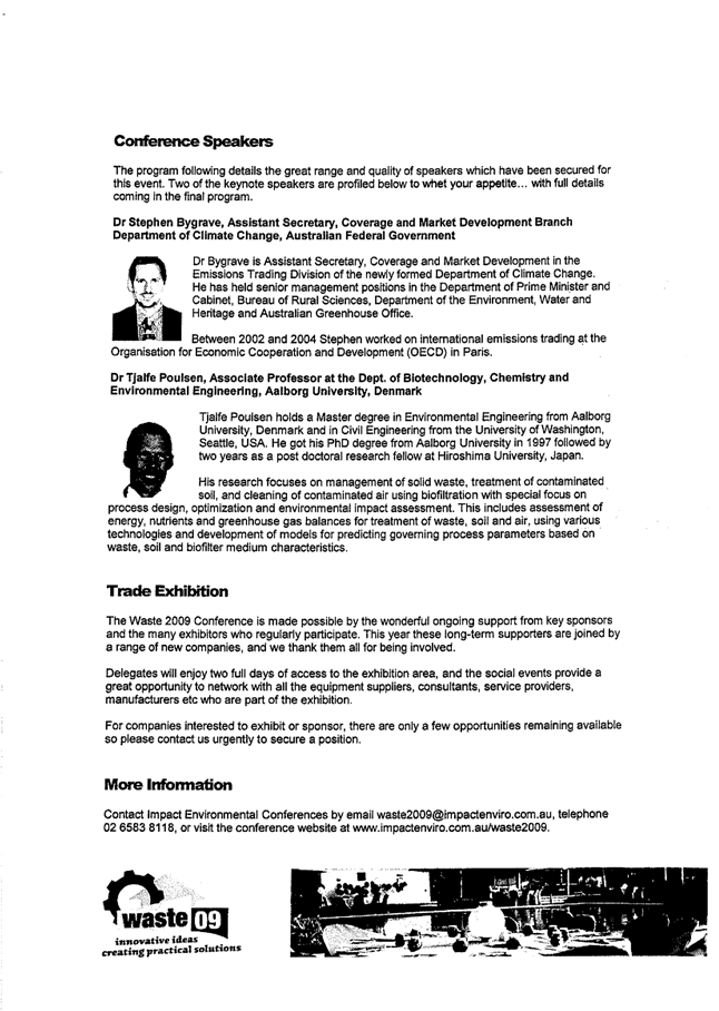
This year’s
Waste Conference is being held at Coffs
Harbour between Tuesday
31 March and Thursday 2 April 2009.
A significant
feature of the program will be addressing the latest issues on the Federal
Government’s recently released Carbon Pollution Reduction Scheme White Paper.
There will
also be a number of sessions covering the landfill levy, contracts and
tenders for Alternate Waste Technologies (AWT), innovative landfill
management, resource recovery, E-waste and waste education strategies. A copy of the preliminary conference
program is at Attachment 1 to this
report.
Arrangements
are in train for up to two Council Officers to attend. It is suggested that Council send up to two
Councillor delegates to this conference due to the importance of continued
research on long term waste disposal options as well as keeping informed
about Carbon Pollution and Waste Levy issues.
|
|
RECOMMENDED that
Singleton Council send up to two delegates from the elected Council to the
Waste 2009 Conference to be held at Coffs Harbour
between Tuesday 31 March 2009 and Thursday 2 April 2009, and
further, that Council determine which Councillors attend.
 
Leisa
Parsons Brian
Carter
Waste
Coordinator Acting
Director Operations
|
|
AT-1View
|
Waste
09 Conference
|
5 Pages
|
|
Attachment 1
|
Director Operations Report No.
2/09
|
|
Waste 09 Conference
|
Waste Conference 2009
|
|
|
|
|
SINGLETON COUNCIL
|
Meeting of Singleton Council - 2 February 2009
|
|
|
|
|
|
Manager
Community Services Report No. 1/09
|
|
|
|
|
1.
|
Community
Grants
Author: Jennifer Blythe
|
FILE: 05/0104
|
|
Detail:
This
report describes the activities of the Community Grants Project Officer for
December 2008 and January 2009. (Officer
on leave from 19 December 2008 – 6 January 2009.)
|
Funding Applications Submitted – Council
|
Dept
|
Project
|
Funding Body
|
Project Amount
|
Grant Amount
|
|
Parks & Facilities
|
Lockable Art Shed at Youth Venue
New Amenities
Building for Junior Rugby League and Cricket
Cycleway at McDougalls Reserve
Cycleway Village Green
|
Regional & Local Community
Infrastructure Program
|
$476,000
|
$381,000
|
|
Council
|
Singleton Disability: Access All Areas –
Facilities for Whole of Community Participation
|
Regional & Local Community
Infrastructure Program – Strategic Projects
|
$3,756,527
|
$3,314,527
|
|
Parks & Facilities
|
Equipment at All Abilities
Playground Rose
Point Park
|
NSW Dept of Local Government
|
$316,750
|
$20,000
|
|
Library
|
International Women’s Day
|
Office for Women
|
$1,000
|
$1,000
|
Funding Received – Community
|
Organisation
|
Project
|
Funding Body
|
Project Amount
|
Grant Amount
|
|
St Johns Ambulance
|
Volunteer equipment
|
Volunteer Grants Program
|
$8,500.00
|
$8,500.00
|
|
Mt Pleasant P&C
|
Volunteer/sporting equipment
|
Volunteer Grants Program
|
$2,954.00
|
$2,954.00
|
|
Junior Touch Football
|
Volunteer/sporting equipment
|
Volunteer Grants Program
|
$1,050.00
|
$1,050.00
|
|
Senior Citizens
|
Volunteer equipment
|
Volunteer Grants Program
|
$1,357.00
|
$1,357.00
|
|
Uniting Care
|
Volunteer equipment
|
Volunteer Grants Program
|
$2,111.50
|
$2,111.50
|
Projects – Community Groups
v New Projects:
§ Documenting history of Putty
Road
§ Chamber of Commerce – Building our Country grant
§ Veolia Water Project Support
§ Country Arts Support Program Grants/Workshop
§ Allied Health Project
v Ongoing Projects:
§ Singleton Netball Association – additional lighting
§ Singleton Junior Touch Football – new storage shed
§ Hunter Valley
Offroad Association – Camp
Quality Sponsorship
§ Branxton Rodeo Grounds – Lighting
§ Hunter Prelude
§ Witmores
§ EDI Downer
Projects – Council
Ongoing Projects:
§ Rose Point
Park All Abilities Playground
§ BMX Track Upgrade
§ New VIC
Special Projects
§ Area Assistance Scheme
§ Country Arts Support Program (Arts NSW)
Meetings – Community Groups:
§ 9 Dec UnitingCare
§ 9 Dec Hunter Valley
Offroad Racing
§ 10 Dec Allied Health
§ 10 Dec Hunter Valley
Offroad Racing
§ 10 Dec Singleton Interagency
§ 16 Jan St Johns
Ambulance
Meetings – Council:
§ 27 Nov Coal & Allied
Steering Committee
§ 5 Dec Area
Assistance Scheme Local Ranking Committee
§ 15 Dec Communications
Committee
§ 16 Dec Cultural Development Advisory Committee
|
FOR COUNCIL’S INFORMATION
|
Attachments
There are no attachments for this report.
|
SINGLETON COUNCIL
|
Meeting of Singleton Council - 2 February 2009
|
|
|
|
|
|
Manager
Community Services Report No. 1/09
|
|
|
|
|
2.
|
Cultural
Development Advisory Committee
Author: Jennifer Blythe
|
FILE: 07/0315
|
|
Executive
Summary:
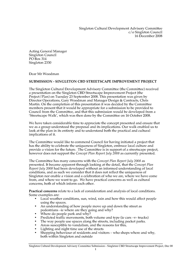
Singleton Cultural Development Advisory
Committee met on Tuesday 16 December 2008 and a copy of the Minutes is
attached as Attachment 1.
The Committee resolved to recommend to
Council the Singleton CBD Streetscape Improvement Project Consultation
Submission be noted.
|
|
RECOMMENDED that:
1. Council note the Singleton Cultural
Development Advisory Committee meeting minutes of Tuesday 16 December 2008.
2. the Singleton Cultural
Development Advisory Committee Submission Singleton CBD Streetscape
Improvement Project, to be signed by Cr Lyn MacBain
as Chair and on behalf of the Singleton Cultural Development Advisory
Committee, be noted.
|
Attachments
|
AT-1View
|
Minutes
Cultural Development Advisory Committee 16 December 2008
|
3 Pages
|
|
AT-2View
|
Singleton
Cultural Development Advisory Committee CBD Streetscape Project Consultation
Submission
|
5 Pages
|
|
Attachment 1
|
Manager Community Services
Report No. 1/09
|
|
Minutes Cultural Development
Advisory Committee 16 December 2008
|
Cultural Development Advisory
Committee
|
|
|
|
Cultural
Development Advisory Committee
Minutes
Tuesday
16 December 2008
Present
Cr Lyn Mac Bain
Jennifer Underwood Manager Community Services
Jennifer Blythe (Acting Manager Community
Services- as of January 2009)
Salena Kearney Manager Tourism
Bridget Nicholson Arts Upper Hunter
Roy Palmer
Jan Fallding
Hope Hardy
Apologies
Cr Godfrey Adamthwaite
Carey Duggan Youth
Programs Coordinator
Kim Horn Parks
Technician
Robyn Tonks Manager
Library
Janice Hanicar
Sheri McEvoy
Debra Hogan Chamber
of Commerce and Industry Inc.
Meeting
commenced at 5.30pm.
1. Welcome to Jennifer
Blythe who will be Acting Manager Community Services when Jennifer Underwood
commences maternity leave in January 2009.
Apologies and previous Minutes accepted
Nicholson/Hardy
2. Business
arising from previous minutes
2.1 Next meeting dates are
recorded incorrectly; should be Tuesday 24 February 2009 & Tuesday 28
April.
2.2 Salena is unable to attend
meetings as coincides with another regular meeting.
2.3 Meeting times were agreed to
be;
- Tuesday 24 February 2009
- Tuesday 31 March 2009
- Tuesday 30 June 2009
- Tuesday 29 September 2009
It was also discussed that additional meeting
times are likely throughout the development of the Cultural Plan over the first
3 months of 2009.
2.3 Outstanding Action sheet items will be
discussed as General Business.
3. General Business
3.1 Singleton CBD Streetscape
Improvement Project consultation submission Draft 2 (Tabled document 1)
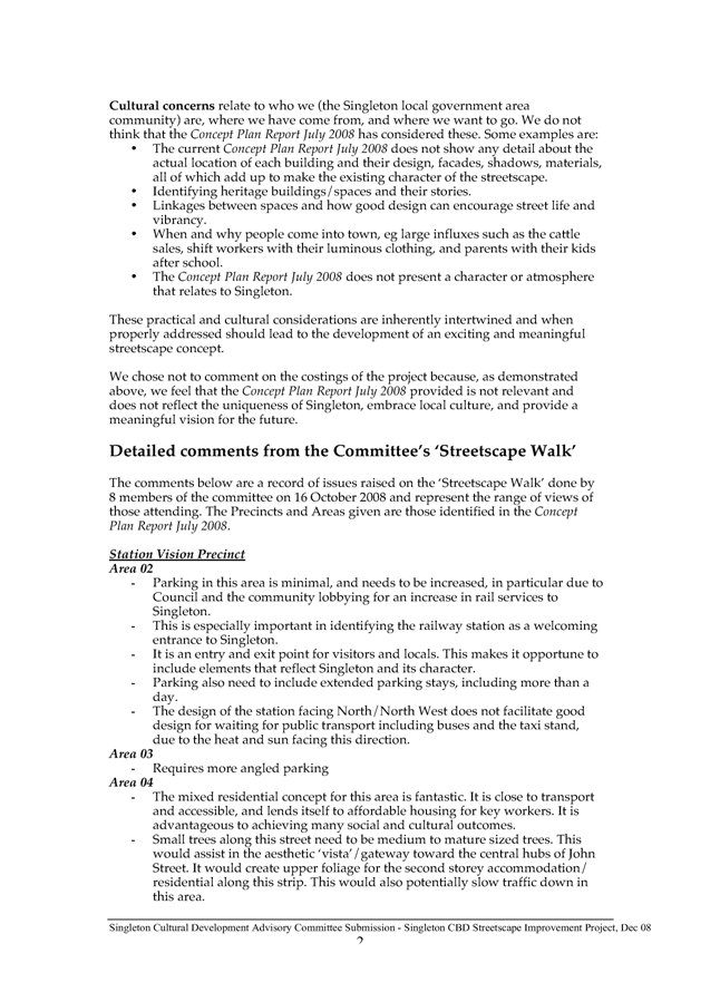
- Feedback was sought from
members of the Committee that were not in attendance at last meeting on Draft 1
of the streetscape consultation submission. Feedback gained didn’t request
changes to be made.
- Discussion was held on Draft
2, with thanks and recognition to Bridget and Jan for developing Draft 2, on
behalf of the Committee.
- Amendments to Draft 2
included grammatical errors and clarification that recognized the Committees
support for the Project, but not for the Concept Report in its current form.
With amendments made, the Committee agreed that the Chair Cr Lyn MacBain would
sign the CDAC Consultation Submission on behalf of the Committee.
Resolved to recommend to Council the Singleton
Cultural Development Advisory Committee Submission Singleton CBD Streetscape
Improvement Project, to be signed by Cr Lyn MacBain as Chair and on behalf of
the Singleton Cultural Development Advisory Committee.
Hardy/Palmer
3.2 Singleton Cultural Plan
- Three quotes were obtained
from cultural planning consultants, and Allan Baptist has been engaged to
develop the Singleton Cultural Plan, based on experience and affordability
within the allocated budget.
- Allan Baptist will be meeting
at Council on 14 January 2009, to develop a detailed Project Plan according to
his submission and the Consultant Brief.
- Members of the Committee were
invited to drop in to meet Allan on the 14 January.
- The possibility of the
consultant being engaged for review of the Plan following its initial
development was raised. This would come at a cost taken from the budget. It was
advised that the Cultural Plan development, implementation and review is one of
the Strategic objectives within the Community Services section of Council’s
Management Plan. It will therefore be implemented and reviewed according to
Council’s reporting and monitoring systems, and reported to Council as part of
the CDAC Meetings/ Minutes.
- The Committee questioned when
they could meet the consultant and it was advised that this would be discussed
with Allan Baptist on the day of his visit on the 14 January, but that his
visits come at a financial cost and will be outlined according to the detailed
Project Plan achieved on January 14.
- The Draft survey questions
were raised as a query of them being used as part of the consultation for the
Cultural Plan. It was advised that the survey questions will be developed with
full consultation of Allan Baptist, and the Draft questions presented were for
the cultural survey component of the Asset Mapping Project. It was agreed that
the questions for both surveys should not duplicate and each of the Project
outcomes would inform the other.
- It was suggested and agreed
that the Community Development Officer-Special Projects, Gail Easton attend the
meeting on the 24 February to brief the Committee on the Asset Mapping Project.
There
being no further general business, the meeting concluded at 7.00pm
Next
Meetings;
All to
be held at 5.30pm in the Committee Room at Council. (Please enter via the
Library car park)
Tuesday
24 February 2009
Tuesday
31 March 2009
Tuesday
30 June 2009
Tuesday
29 September 2009
ACTION
SHEET
Cultural
Development Advisory Committee
16
December 2008
|
ACTION
|
WHOM
|
DEADLINE
|
COMMENTS/COMPLETION
|
|
Invite CDO- Special Projects to meeting on 24 February to give Brief
on Asset Mapping Project
|
A/Manager Community Services
|
January 2009
|
|
|
Detailed Project Plan to be provided to Committee members following
January meeting with Allan Baptist
|
A/Manager Community Services
|
Friday 23 February 2009.
|
|
|
Attachment 2
|
Manager Community Services
Report No. 1/09
|
|
Singleton Cultural Development
Advisory Committee CBD Streetscape Project Consultation Submission
|
Cultural Development Advisory
Committee
|
|
|
|
|
SINGLETON COUNCIL
|
Meeting of Singleton Council - 2 February 2009
|
|
|
|
|
|
Manager
Community Services Report No. 1/09
|
|
|
|
|
3.
|
Colleen Gale
Children's Services
Author: Jennifer Blythe
|
FILE: 01/0447-4
|
|
Detail:
The purpose of this report is to inform
Council of the occupancy and activities of Colleen Gale Children’s Services
for November and December 2008.
|
November 2008
Actual Budgeted
Nursery 100% 85%
2-3 room 91.25% 85%
Preschool 95.75% 85%
Mobile Pre-school 73.13% 50%
Before school care 27% 20%
After school care 90.33%
83.3%
Note: Before, After and Vacation Care figures based on a 30 place capacity.
· The Director Anne Bomann-Maansson resigned as Director after a period
of extended leave. This position will be advertised to find a suitable
replacement.
· Linda Jessop has finished on the Mobile Preschool truck and will
replace Kim Deaves as full-time Administration Assistant while Kim is on
maternity leave.
Long Day Care
· Children have been practising for the Christmas concert.
· Preschool children have been on two excursions to King
Street School
and Hunter Street School
in preparation for many of them starting school next year.
· Children’s Christmas Party was held at the Country Tennis Club in
Singleton on Friday 28th November. This was a new venue for the
Christmas party and we have had positive feedback from staff and parents about
this event. There was a sausage sizzle,
disco, performance and a visit from Santa.
Mobile Preschool
· The children enjoyed learning about sand and water wheels.
· Children learned what to do in a fire and practised “get down low and
go go go.”
· Many children have shown an interest in the alphabet and counting. Some
of the older children have been practising counting to 20.
OOSH
· Children have been very imaginative in their play, including playing
“schools” and operating a Café.
· Children have been very interested in the different countries from
around the world and have incorporated this into their play.
December 2008 report
Actual Budgeted
Nursery 100% 85%
2-3 room 91.02% 85%
Preschool 90.31% 85%
Mobile Pre-school 75% 50%
Before school care 18.88% 20%
After school care 78.44%
83.3%
Note: Before, After and Vacation Care figures based on a 30 place capacity.
· Advertisements and interviews for two new Long Day Care staff members
completed.
· Lauren Mills (previously Acting Director) has been employed as
Director.
Long Day Care
· Children have been enjoying making lots of Christmas craft including
wreaths, sequin angels and hand and footprint reindeers.
· There have been lots of Christmas songs sung and stories read. One of
the favourites has been ‘Six White Boomers’.
Mobile Preschool
· Children have been practising for their Christmas concert. Parents came
in for the second last week of term to watch the children perform and to see
them receive their graduation certificates.
· Christmas craft has been a favourite activity. Children made wreaths,
snow flakes, little Santa Clauses and Christmas trees.
· Children have been practising cutting out toys they want for Christmas
from publications.
OOSH
· As part of the Active After School Program children have enjoyed
swimming activities at the pool two afternoons a week.
· A Christmas Disco party was held at the Youth Venue on Thursday 11th
December. It was a great afternoon with children demonstrating their best
singing voices on the Karaoke machine and doing some great dancing on the dance
floor.
· Children have been tinkering with old electronic items. They have been
pulling apart a printer, fax machine, play stations and an old computer.
· For the Christmas celebrations children made gingerbread men, cards and
presents. Many children became involved in pretend play relating to Christmas,
making presents and then pretending to deliver them.
|
FOR COUNCIL’S INFORMATION
|
Attachments
There are no attachments for this report.
|
SINGLETON COUNCIL
|
Meeting of Singleton Council - 2 February 2009
|
|
|
|
|
|
Manager
Community Services Report No. 1/09
|
|
|
|
|
4.
|
Youth
Programs
Author: Jennifer Blythe
|
FILE: 01/0393
|
|
Detail:
The
purpose of this report is to inform Council of the attendance and
participation at the Singleton Youth Venue and of youth activities and events
for November and December 2008.
|
November
Youth Venue Based
Activities
November 2008 November 2007
Male: 300 256
Female: 265 170
Total: 565 426
11-14: 330 235
15-17: 202 151
Over 17: 32 40
Referrals
Male: 0
Female: 1 (DoCS referral)
Off-site Activities
Commercial
Radio workshop’s industry visit to Power FM: 10
participants attended.
Issues
DoCS
/Youth-related issue resulted in 2 staff remaining at venue until 1.30am on
29/11/08. Positive outcome resulted due
to staff professionalism and procedural practice.
Reports/Funding Applications
Youth
Week 2009 application submitted.
Drive
Alive shuttle bus funding application submitted.
Meetings attended.
§ Upper Hunter Youth Network Interagency
§ Streetscape Forum
§ Domestic Violence Committee
§ Hunter Youth Sexual Health Network
§ Upper Hunter Child Protection
§ Singleton High
School Welfare Faculty
Activities/Events
§ Live theatre production in auditorium on Sunday 16th November
§ Arts Upper Hunter and Art Start Youth Band CD launch 29th November
attracted 107 people
§ Singleton Youth Venue Open Day 29th November not as successful as hoped
but a number of community members and parents visited.
Planned Activities/Events December 2008
§ Op Shop Extravaganza and fashion parade Friday 12th December
§ Christmas Chaos Youth Band Night Saturday 20th December 6 to 11.30pm
featuring 5 local youth bands. Security
was booked and event registered with Police.
§ Family Relationships Community Expo.
§ King Street
School presentation and disco Monday
15th December
Holiday Operating Hours
Youth
Venue will close from Friday 19th December and reopen on Tuesday 6th
January 2009.
Coordinator
will be on holidays from 24th December until Friday 5th
January 2009.
Events Planned for 2009
§ Booking taken for Travelling Opera company production for May 2009.
§ Booking taken for TAFE outreach mentoring training for March 2009
§ Booking taken for Family Insight volunteer training for February 2009.
Workshops
§ Break-Dance workshop cancelled in early November due to falling
numbers. Since then a number of parents
have contacted venue to discuss reintroduction in 2009.
§ Belly dance continues to attract approximately 8 participants each
session.
§ Fashion Girls workshops continues to attract an average of 8
participants each session.
Venue Hire
The following
services/committees hired rooms in November:
§ Singleton High School SRC (student
representative council)
§ Singleton High School Home
Economics teachers
§ Juvenile Justice Health
§ DoCS
§ Wonnarua Nation directors meeting
§ Domestic Violence Committee
§ Working Community Partnerships
§ Arts Upper Hunter
§ Legal Aid
§ Adolescent and Family Counsellor
§ Family Relationships.
December
Youth Venue Based
Activities
December 2008 Nov/December 2007
Male: 265 256
Female: 255 170
Total: 520 426
11-14: 303 235
15-17: 122 151
Over 17: 95 40
Referrals
Male: 1 (DoCS Referral - notification and
follow up)
Female: 0
Off-site Activities
No
off-site activities in December.
Issues
§ Police called to incident at centre involving 3 males and 1 female who
were being abusive to staff. Police
escorted one male from the venue in restraints before releasing him
outside. The person, and three others
left venue but returned later with a larger group of friends, Police were again
notified and attended within 15minutes.
Group had left when police arrived.
These four people have had letters of expulsion (with offers to attend
meeting with venue staff) delivered to them and their parents.
As a
result of this incident security personnel are now present on function nights.
Reports/Funding Applications
§ Funding application for Macquarie Generation and Country Arts Support
Program being prepared to assist with the costs of:
o 10 week Drama/Comedy/workshops and production
o Funding to facilitate multi facet dance workshops
Meetings/Forums/training attended
Youth
Program Coordinator attended the following meetings:
§ Pat Wade from DADHC in regards to disability client access to volunteer
work at venue. (Client attending one day a week)
§ TAFE Outreach coordinator in regards to Plan-it-Youth mentoring
§ Training booked to commence Tuesday 10th March at Youth Venue
§ Singleton police in regards to incident Friday 5th December
§ Community Service Interagency
§ Autism Forum
§ ABCD 3 day forum, Newcastle
§ SPACE/Better Futures Forum.
Activities/Events
§ Whitmore Enterprises attended for Disability Week and conducted an art
program
§ Interrelate (Family Relationship Centre) conducted a Community Expo for
residents
§ Singleton High
School conducted staff training days during December.
§ Family Insight Autism Forum attracted nearly 100 people
§ OOSH staff and children held a Christmas Disco
§ Singleton Public
School held their year 6 presentation and farewell party for more than 150
people
§ Saturday 20 December an All Ages bands night and Christmas party was
held with 4 local youth bands performing and 87 young people attended.
2009
Workshops/Activities/Events
The
followings are planned for 2009:
§ Belly Dance (weekly)
§ Fashion Girls (weekly)
§ Guitar and Drum tuition (weekly)
§ Drama and Comedy (10 week program, May to August) – subject to funding
application
§ Movie making program (April and September)
§ Battle of the Bands /Youth Week (Heats
on 13 & 27 March; Final on 3 April)
§ Skate competition/Youth Week (28 March)
§ NAIDOC week (5-12 July)
Venue Hire
The following
services/organizations hired venue facilities in December:
§ Family Relationship Centre
§ Legal Aid
§ Juvenile Justice
§ Wonnarua Aboriginal Corporation
§ Singleton Disability Committee
§ Singleton Public
School
§ Singleton Community Service Interagency
|
FOR COUNCIL’S INFORMATION
|
Attachments
There are no attachments for this report.
|
SINGLETON COUNCIL
|
Meeting of Singleton Council - 2 February 2009
|
|
|
|
|
|
Manager
Community Services Report No. 1/09
|
|
|
|
|
5.
|
Community
Development November 2008 - January 2009
Author: Wendell
Peacock
|
FILE: 01/0163-2
|
|
Detail:
The purpose of this report is to inform
Council of the key activities of the Community Development Officer (CDO) and
Community Development Officer – Special Projects (CDO-SP) for the months of
November/December 2008 and January 2009.
|
Disability
The Singleton
& District Disability Advisory Committee attended a presentation on the
proposed Streetscape Plan on 11 November and made a submission to the project.
The costings
report for the Singleton Disability Access Action Plan, which detailed the cost
of all required work to buildings & facilities, footpaths & kerb ramps,
and proposed priorities and a strategy for ensuring the items are included in
future budgets, was presented at the 1 December Council meeting. The report was
approved and put on public exhibition until 28 February.
The Singleton
District Disability Advisory Committee met on 2 December 2008. The art
exhibition and community art event held in Town Square
on 3 December was very successful, as was the official opening of the Liberty
Swing on 10 December. Both events were well covered by the Singleton Argus.
The CDO and
Community Grants Officer assisted with the preparation of the application for
funding for the Commonwealth Infrastructure grant in December. The Disability
Access works for Council facilities and footpaths and kerb ramps (from the
Disability Access Action Plan) were combined with the finalisation of the
All-Abilities Playground and the construction of the Hydrotherapy Pool in a
project called Access All Areas. Members of the Disability Advisory Committee,
as well as Councillors, assisted with soliciting letters of support from the
community, and a total of 42 were included with the submission.
Interagency
The Interagency
met on 10 December 2008, with a presentation from Leapfrog Ability, and most of
the meeting focused on reviewing the Terms of Reference, before a Christmas
afternoon tea. Members resolved to participate in a workshop to review the
Social Plan on the day of the next meeting – 11 February 2009.
Housing
The Upper Hunter
Strategic Housing Action group met on 26 November, with most of the discussion
focusing on the statistics needed from service providers and other institutions
in the community to accurately describe all aspects of the housing situation,
and suggestions for other services that can be invited to attend. Noel Downs
from Wonnarua LALC attended and provided an update on the situation for the
indigenous community, and the Land Council’s plans for the future.
The CDO attended
a workshop on Affordable Housing run by NCOSS and Shelter NSW on 27 November, where
the Strategic Housing Action Group was received as an innovative strategy to
address housing issues.
Ageing Community
The CDO attended
the Positive Ageing Strategy Hunter Advisory Committee meeting and Community
Settings Working Group meeting, and met with a regional manager for Uniting
Care to discuss service issues and potential collaborations. Attendance at the
Health Advisory Committee on 11 December resulted in awareness of Hunter New
England Area Health Service proposed service plan, and contact with the Health
Services planner for Ageing.
Community Safety
The draft Crime
Prevention Strategy 2009/2010-2012/2013 was presented to Council on November 3,
and Council recommended that the Strategy be adopted after the appropriate
public exhibition period. No submissions were made and the Strategy is now
Council Policy Number 21079.1. The Strategy has been forwarded to the Attorneys
General Department for endorsement. If the Department endorses the Strategy,
funding opportunities could be available for some of the strategies.
The Singleton
CDO hosted a Community Safety Working Group of the Hunter Councils Community
Development and Social Planning Team, which aims to share knowledge relating to
the development of crime prevention plans.
CDSE Committee
Although the
Singleton Clubs did not generate enough income to be required to run a CDSE
grants scheme, the Clubs wish to continue to run the Committee on an informal
basis to support the decision-making process for the Community Chest grants and
to maintain the process in the event that a Committee is required by Clubs NSW
in the future. The Committee met on 21 January, to determine closing dates for
applications (20 March) and the date for an assessment meeting. The CDO is a
member of the Committee to provide advice on Council’s priorities.
Safety within the Family Project
The part-time
Project Officer was engaged and commenced with Council on 5 January 2009. The Project Officer will undertake necessary
research and establish the Steering Committee.
Asset
Mapping/Asset Based Community Development
Consultation has
commenced with initial introduction of the project to community and Council
Committees.
Training
The CDO and
Special Projects Officers attended the Asset Based Community Development Asia
Pacific Conference in Newcastle,
3-5 December, along with most of the Community Services Team. There were many
international and local presenters, and keynote speakers who were part of the
formation of this approach to working with communities.
Gail Easton will
be acting in the Community Grants Project Officer role while Jennifer Underwood
is on maternity leave, and Aoife O’Toole will be acting as Community
Development Officer Special Projects Officer during that time.
The CDO - Special Projects was on leave
from 17 December until 6 January 2009.
|
FOR COUNCIL’S INFORMATION
|
Attachments
There are no attachments for this report.
|
SINGLETON COUNCIL
|
Meeting of Singleton Council - 2 February 2009
|
|
|
|
|
|
Manager
Community Services Report No. 1/09
|
|
|
|
|
6.
|
Singleton
Disability Advisory Committee Meeting
Author: Jennifer Blythe
|
FILE: 01/0465
|
|
Executive
Summary:
The Singleton
and District Disability Advisory Committee Meeting was held on Tuesday 2nd
December 2008. The Minutes and actions
of this meeting are attached
(Attachment 1).
The
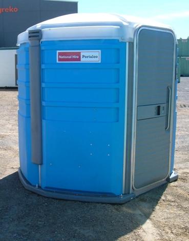
recommendation put forward by the Committee is that a Portable (Drop) Access Toilet be provided in close proximity to the
All Access Equipment and the Liberty Swing in Rose Point
Park until such time as
a permanent facility can be funded and provided.
|
Conclusions:
National Hire,
Council’s supplier of portable toilets, has available a toilet which provides
access for wheelchairs, and this is available for hire by Council at a cost of
$110 per week including servicing and an $220 for delivery and collection. Staff at National Hire, however, did advise
that this portable toilet, like all portable toilets, is usually hired to
provide a facility for specific events or functions. In this environment use of the toilet is
supervised to some extent. Should the
toilet be left unsecured and unsupervised in a park it would be susceptible to
vandalism. Council would be responsible
for any damage as no damage waiver is offered in the hire contract of this
facility.
The Acting Manager
Parks and Facilities has advised that
potential vandalism in Rose
Point Park
is a concern. The Acting Manager
Parks and Facilities
further added that most parks in Singleton have no disability access toilets,
and that many parks have no toilet facilities.
Two funding
applications were submitted in 2008, both of which include provision for a
permanent disability access toilet at this location.
1. Provision of a
disability access toilet, as part of the All Abilities Playground project, was
included in the Access All Areas grant submitted in December 2008. The Minister for Infrastructure, Transport, Regional Development and Local
Government expects to announce successful projects by end of February 2009.
2. Provision
of a disability access toilet, as part of the All Abilities Playground, was
included in an application to the Xstrata Corporate Social Involvement
Program. The outcome of this application
is expected late February 2009.
Given that the
result of these two funding applications, which would provide a permanent
disability access toilet, will shortly be announced, and given that provision
of a temporary facility appears to pose a risk of vandalism at this location,
the most appropriate course of action is for Council to continue to seek
funding for a permanent disability toilet.
|
RECOMMENDED
that:
1. Council
note the Minutes of the Singleton and District Disability Advisory Committee
Meeting held 2 December 2008.
2. Council
note the Singleton and District Disability Advisory Committee’s
recommendation that a Portable (Drop) Access Toilet be provided in close
proximity to the All Access Equipment and the Liberty Swing in Rose Point
Park until such time as
a permanent facility can be funded and supplied.
3. Council continue to seek funding for
completion of the All Abilities Playground project including provision of
public toilets and disability access toilets.

Jennifer Blythe Brian Carter
Acting
Manager Community Services Acting
Director Operations
|
Attachments
|
AT-1View
|
Minutes
Singleton and District Disability Advisory Committee December 2008
|
8 Pages
|
|
Attachment 1
|
Manager Community Services
Report No. 1/09
|
|
Minutes Singleton and District
Disability Advisory Committee December 2008
|
Singleton Disability Advisory
Committee Meeting
|
|
|
|
|
SINGLETON COUNCIL
|
Meeting of Singleton Council - 2 February 2009
|
|
|
|
|
|
Manager Parks and Facilities Report No. 2/09
|
|
|
|
|
1.
|
Singleton
Lions Club - Expo Site Electrical Power Boxes
Author: Alan Fletcher
|
FILE: 09/0004
|
|
Detail:
On the 27 October 2008 Cr. Scott tabled a Notice of Motion:-
“Singleton
Council withdraw the account issued to Singleton Lions Club in relation to
the recent Lions Expo for the amount charged beyond what was previously
agreed to be waived by Council and that funding be sourced from Council’s
donation vote”.
Council
resolved that a further report be provided to Council on the costs of the
electrical installation in Civic
Park for the Lions Club
Expo following liaison with the Singleton Lions Club.
Singleton Lions Club use the Auditorium plus
the grassed area between the Civic Centre
and the Hunter Prelude building for the Lion Club Home and Leisure Expo. In accordance with Council Policy Number
25001.1 Council provides the use of the Auditorium and grassed area free of
charge. The normal cost is:-
· Hire of auditorium
$4,000
· Hire of grass land
for commercial use $175/day for three days = $525
The Lions Club provided an expo site in the auditorium for Council as
a part of the arrangement.
Historically the Lions Club had enjoyed
assistance from Energy Australia
who provided two unmetered electricity supply points free of charge. Energy Australia advised that they were
unable to provide an unmetered service in the future. The Lions Club asked Council for funding
for the equipment which was quoted by the Lions Club at $5,379.70. The Lions Club was to provide the
labour. Council resolved that the cost
for the power outlets be included in 2008/09 budget.
This was done and the work was completed
prior to the Expo in August 2008. The
work came to a total of $6,797.88 including GST plus Energy Australia costs of $475.75 which
was paid by Singleton Council. This is
an over expenditure on the original estimate of $1,418.18 including GST. The Manager Parks and Facilities contacted
members of Lions Club and advised them an invoice would be sent to the Lions
Club for the extra cost over the quoted cost.
The Lions Club Expo is likely to be the only users of the electrical
boxes.
On the 8 December 2008 Mr. John Tindale the Lions Club Treasurer had
discussions with the Manager Parks & Facilities about a number of items
on the invoice. The outcome was the
amount that was reduced to $648.53 and the Lions Club paid the invoice.
|
|
FOR COUNCIL’S INFORMATION

Kim Horn Brian
Carter
Acting Manager
Parks & Facilities Acting
Director Operations
|
Attachments
There are no attachments for this report.
|
SINGLETON COUNCIL
|
Meeting of Singleton Council - 2 February 2009
|
|
|
|
|
|
Manager
Water and Waste Report No. 1/09
|
|
|
|
|
1.
|
Water and
Sewer Reports - 01/11/2008 - 31/12/2008
Author: Ben Sim
|
FILE: 01/0153
|
1. Water and Sewer Report – 01/11/2008 –
30/11/2008
a. Singleton Water Supply
|
|
01/11/2008 – 30/11/2008
|
2007 Figures
|
|
Total throughput from dam was
|
217
ML
|
198
ML
|
|
Consumption
|
|
|
|
Town
|
167
ML
|
151
ML
|
|
Army
|
6 ML
|
7 ML
|
|
Abattoir
|
13 ML
|
13 ML
|
|
Mount Thorley/Broke
|
17 ML
|
7 ML
|
|
Standpipe (water to Industry and Rural)
|
14 ML
|
20 ML
|
The trend in treated water consumption for
Singleton town is shown on the following graph:
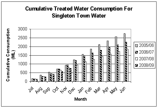
The graph shows that for the same period
during the last four years, this years cumulative treated water consumption (up
to and including the month of November) continues to be the lowest.
Average
Daily Water Consumption for Singleton
Town Residential
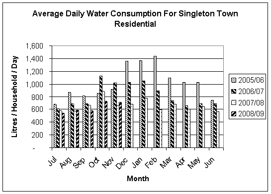
As shown on the
above graph, the average daily water consumption for the month of
November 2008 is 710 litres per household per day. It is marginally the second lowest as
compared to the same month in the previous four years.
Dam
Percent Full
As advised by State Water, Glennies Creek
Dam was 68.8% full on 30 November 2008.
Thus, in the month of November 2008, the water storage volume in the dam
had a slight decrease of 0.5%.
New
Services
4 new services were installed this month.
Service
Repairs
30 service repairs were carried out this
month, including 21 complete renewals.
Hydrant
Repair
A damaged hydrant on the main supply line
to Broke was replaced this month.
Main Breaks
5 main breaks were repaired this
month:
Ø Opposite 9 Loder Avenue (100 mm diameter AC main –
blow out)
Ø 5 Shaw Street
(100 mm diameter AC main – blow out)
Ø 10 Loder Avenue
(100 mm diameter AC main – blow out)
Ø Church Street
near end of Shaw Street
(100 mm diameter AC main – blow out)
Ø At intersection of Loder Avenue and Kelso Street (100 mm diameter AC main –
radial crack)
Meters
M & R
75 water meters were replaced this month.
New
Valves and Hydrants
A valve (300 mm
diameter) and tee was installed this month on the 450 mm diameter AC main
leading to Gowrie Reservoir. This will
be the water connection point for the Gowrie Links Development.
b. Mount Thorley
Water Supply
|
|
01/11/08 – 30/11/08
|
2007 Figures
|
2006 Figures
|
2005 Figures
|
2004 Figures
|
|
The total amount of water pumped to
the mines in November was
|
54 ML
|
101
ML
|
343
ML
|
90 ML
|
77 ML
|
The trend in raw water consumption at Mount Thorley
is shown on the following graph:
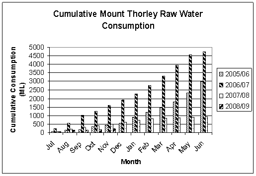
The graph shows that this years cumulative
raw water consumption (up to and including the month of November) is the lowest
as compared to the same period in the previous four years.
Meters
M & R
1 water meter was replaced this month.
c. Jerrys Plains Water Supply
|
|
01/11/2008 – 30/11/2008
|
2007 Figures
|
|
Consumption
|
2.08
ML
|
1.32
ML
|
The trend in water consumption at Jerrys
Plains is shown on the following graph:
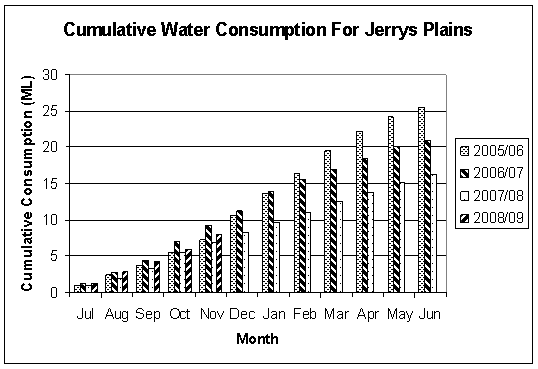
As compared to
the same period in the previous four years, the graph shows that this years
cumulative water consumption (up to and including the month of November) is the
second lowest.
Main
Breaks
Two main breaks were repaired this month:
Ø Pagan Street
(63 mm diameter Poly main – longitudinal split)
Ø Bureen Street
(63 mm x 50 mm x 40 mm Poly connection – blow out)
d. Sewer System Report
|
|
01/11/2008 – 30/11/2008
|
2007 Figures
|
|
Sewerage Treatment Works – Flow Volume
|
107
ML
|
106
ML
|
Effluent Reuse
Total estimated effluent reuse for
this financial year is 184 megalitres, after being adjusted for full water
losses.
Sewer
Main M & R
7 sewer chokes or problems were attended to
this month:
Ø 35 Lachlan Avenue (cleared main)
Ø Mercy Rest Home in Civic Avenue (cleared main)
Ø 9 Cambridge Street (sewer dig up repair)
Ø 2 Burbank Crescent (sewer dig up repair)
Ø 78 York Street
(sewer dig up repair)
Ø 59 Benjamin Circuit (sewer dig up repair)
Ø 5 Gostwyck Close (sewer dig up repair)
Dunolly
Pump Station M & R
Repairs to the pump station ventilation
system were completed this month.
Manhole
(MH) M & R
Three manholes were repaired or attended to
this month:
Ø 78 York Street
(raised)
Ø 75 High Street
(replaced lid and surround)
Ø 3 Knox Place
(raised)
Vent
Stack Replacement Program
One steel vent stack was installed this
month:
Ø 78 York Street
Low
Pressure Sewerage (LPS) System (a majority at Maison Dieu Industrial Estate)
No sewer POD was connected to the system
this month, with a total of only one being installed this financial year.
2. Water and Sewer Report – 01/12/2008 –
31/12/2008
a. Singleton Water Supply
|
|
01/12/2008 – 31/12/2008
|
2007 Figures
|
|
Total throughput from dam was
|
185
ML
|
193
ML
|
|
Consumption
|
|
|
|
Town
|
152
ML
|
163
ML
|
|
Army
|
4 ML
|
6 ML
|
|
Abattoir
|
10 ML
|
9 ML
|
|
Mount Thorley/Broke
|
8 ML
|
7 ML
|
|
Standpipe (water to Industry and
Rural)
|
11 ML
|
8 ML
|
The trend in treated water consumption for
Singleton town is shown on the following graph:
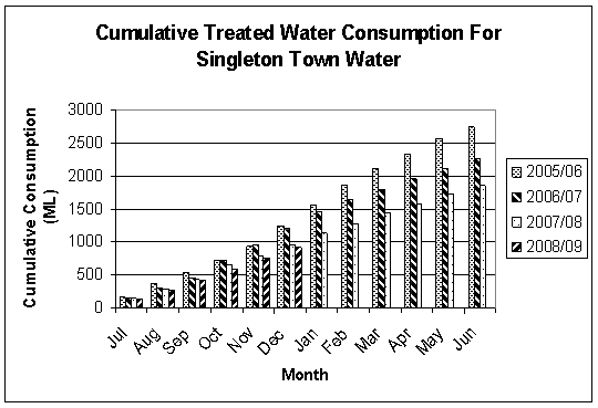
The graph shows that for the same period
during the last 4 years, this years cumulative treated water consumption (up to
and including the month of December) continues to be the lowest.
Average
Daily Water Consumption for Singleton
Town Residential
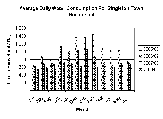
As shown on the
above table, the average daily water consumption for the month of December 2008
is 625 litres per household per day. It
is the lowest as compared to the same month in the previous four years.
Dam
Percent Full
As advised by
State Water, Glennies Creek Dam was 68.3% full on 31 December 2008. Thus, in the month of December 2008, the
water storage volume in the dam has had another slight decrease of 0.5%.
New
Services
1 new service was installed this month.
Service
Repairs
14 service repairs were carried out this
month, including 3 complete renewals.
Main
Breaks
4 main breaks were repaired this month:
Ø Judan Road (63
mm diameter Poly main – longitudinal split)
Ø 31 Bishopgate Street (100 mm diameter AC main – cracked at collar)
Ø Corner Kelso and Bond Streets (100 mm
diameter AC main – blow out)
Ø Campbell Street
(200 mm diameter PVC main – longitudinal split)
Meters
M & R
35 water meters were replaced this month.
Mains
Replacement/Relocation
A total of 265 meters of water main was
replaced in Shaw and Rawcliffe Streets this month.
Valves
and Hydrants M & R
Two valves were replaced this month:
Ø Hambledon Hill Road
Ø Corner of Broughton and Boundary Streets
b. Mount Thorley
Water Supply
|
|
01/12/08 – 31/12/08
|
2007 Figures
|
2006 Figures
|
2005 Figures
|
2004 Figures
|
|
The total amount of water pumped to
the mines in December was
|
17 ML
|
109
ML
|
304
ML
|
98 ML
|
88 ML
|
The trend in raw water consumption at Mount Thorley
is shown on the following graph:
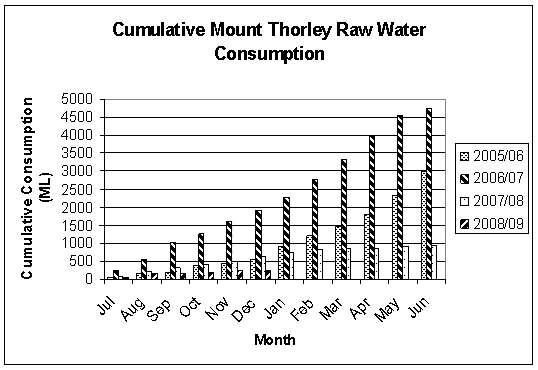
The graph shows that this years cumulative
raw water consumption (up to and including the month of December) is still the
lowest as compared to the same period in the previous four years.
c. Jerrys Plains Water Supply
|
|
01/12/2008 – 31/12/2008
|
2007 Figures
|
|
Consumption
|
2.16
ML
|
1.31
ML
|
The trend in water consumption at Jerrys
Plains is shown on the following graph:
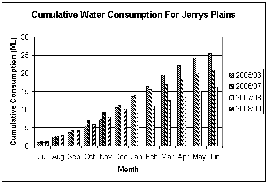
As compared to the same period in the previous
four years, the graph shows that this year’s cumulative water consumption (up
to and including the month of December) has stabilised, becoming the third
lowest accumulated consumption over the last four years.
Main Breaks
1 main
break was repaired this month:
Ø Queen Street (63 mm diameter Poly main –
longitudinal split)
d. Sewer
System Report
|
|
01/12/2008 – 31/12/2008
|
2007 Figures
|
|
Sewerage Treatment Works – Flow Volume
|
107
ML
|
105
ML
|
Effluent Reuse
Total
estimated effluent reuse for this financial year is 219 megalitres, after being
adjusted for full water losses.
Sewer Main M & R
4
sewer chokes or problems were attended to this month:
Ø 2 times at 1 Knox Place
(cleared shaft)
Ø 133 Gardner
Circuit (cleared shaft)
Ø 70 Gardner
Circuit (cleared main)
Manhole (MH) M & R
2
manholes were repaired or attended to this month:
Ø Douglass Place (raised)
Ø Willcox Avenue (built retaining wall around
manhole)
Sewer Main
Cut In
A cut in
at the 450 mm diameter gravity sewer main along Bridgman Road was carried out this month,
to allow for the connection of sewer services from the Bridgman Ridge
subdivision.
Low Pressure Sewerage (LPS) System (a
Majority at Maison Dieu Industrial Estate)
No sewer
POD was connected to the system this month.
The total
number of sewer PODs connected to the LPS system remains at 91 and the total
for this financial year is still 1.
e. Training/Safety/Conferences/Exhibitions
An 8 hour
OH&S Forum (held at Ironbark Winery) was attended by the following Water
& Waste Staff (with other Council Staff from various departments) this
month:
Ø Ian Vickers
Ø Gary Perrin
Ø Chris Smith
|
FOR COUNCIL’S INFORMATION
|
Attachments
There are no attachments for this report.
|
SINGLETON COUNCIL
|
Meeting of Singleton Council - 2 February 2009
|
|
|
|
|
|
Manager
Water and Waste Report No. 1/09
|
|
|
|
|
2.
|
Water Reform
- Inquiry into Secure and Sustainable Urban Water Supply and Sewerage
Services for Non-Metropolitan NSW
Author: Brian Carter and jeff Burgman
|
FILE: 05/0121
|
|
Executive
Summary:
The report of the Independent Inquiry into
Secure and Sustainable Urban Water Supply and Sewerage
Services for Non-Metropolitan NSW was completed in December 2008 and released
by the Minister for Water, the Hon Phillip Costa MP, on 14 January 2009.
|
The report recommends regional aggregation of
water and sewerage services across NSW into 32 groupings of Council areas, with
several options for this aggregation being identified. The report also recommends a specific service
aggregation method for groupings of Councils across NSW.
The report proposes a binding alliance model
for Singleton, Muswellbrook and the Upper Hunter local government areas. The exact legal status and legislative guides
for such an alliance are yet to be finalised.
Further
submissions to the Minister have been invited and will be accepted up to 20
March, 2009.
This report recommends that Singleton Council
holds joint discussions with Muswellbrook and Upper Hunter Councils. The intention is to thoroughly investigate
joint servicing and grouping of the three councils, with the aim of developing
a common view and a joint submission for the Minister.
Background:
In August/September 2007 the Minister for
Water, the Hon Nathan Reese MP, announced an enquiry into Water Supply and Sewerage
Services in Non-Metropolitan NSW.
In April 2008, Singleton Council senior
officers prepared a submission to the inquiry outlining Council’s “strong
preference for the continued involvement of local government in the provision
of water and sewer services, and the continued ownership of the infrastructure
required to provide these services”.
Council also expressed its preference to continue with the status quo,
bearing in mind its financially sustainable position and inability to share
major water sourcing or sewerage infrastructure with surrounding councils. Councillors were kept up to date through
briefings and reports during this process.
A presentation to this effect was also made
by Singleton Council at an enquiry hearing in Tamworth
on 13 May 2008.
The independent report recommends that
Singleton, Muswellbrook and Upper Hunter Councils form a binding alliance. Full copies of the report will be forwarded
to Councillors under separate cover and the binding alliance model is explained
in detail in Appendix 2, pages 113 to 116 of the report. This model in essence proposes centralised
planning and technical functions, with an emphasis on strategic and financial
planning. The alliance entity would have
the power to require price setting and certain capital works to be undertaken
by constituent councils.
This concept now needs to be considered in
detail with a joint submission by all three councils to the Minister being the
preferred method to further progress this matter.
A preliminary meeting with Muswellbrook and
Upper Hunter Council was held on 20 January 2009, with both Senior Officers and
the Mayors of all three Councils attending.
Considerable investigation work now needs to
be completed by Council Officers and a further report to Council is expected to
be made available in March, enabling the joint submission to the Minister.
Management
Plan:
It is possible that there will need to be
major changes to future Council Management Plans as a result of this water
reform process. At the present time it
is not possible to quantify them in any detail.
Council
Policy:
Again, a number of Council’s Water &
Sewer Policies may need to be reviewed.
At present it is not possible to provide further comment for Council’s
consideration.
Legislation:
It is anticipated that enabling legislation
to control a number of matters considered in the enquiry may be enacted. Areas with the potential to be affected by
this include provision for mandatory alliances of councils for certain water
and sewer services, water and sewer price setting and increased State
Government Regulation and Control of the water and sewer industry.
Sustainability:
One of the stated aims of the Minister in
ordering this review was to improve and enhance the sustainability of Council’s
water and sewer operations. Further
consideration of this matter will be required when the way forward for
Singleton becomes clearer.
Consultation:
The State Government has ensured that there
has been extensive consultation with the wider community up to date and it is
to be hoped that this process will be continued. Council has not to date had the opportunity
to undertake any significant community consultation at a local level. Once again, it is likely that such
consultation will commence once the way ahead for Singleton becomes clearer.
Risk
Management:
Not applicable.
Options:
Council
has three options:
1. Continue to advocate the status quo for
Singleton.
2. Investigate and submit comments to the
Minister in support of the recommended binding alliance between Singleton,
Muswellbrook and Upper Hunter Councils.
This could involve either a joint submission with the other Councils or
by individual submission to the Minister.
3. Suggest a viable alternate arrangement to the
Minister other than that recommended in the report. Again this could be a joint
or individually prepared submission.
Conclusions:
It is clear that the State Government intends
to implement water reform and that they have stated that there is a need to
improve organisational structures and regulations to ensure good governance and
financial sustainability, cut State Government red tape and ensure skilled
staffing is available. In many cases,
whilst changes may need to be made and service levels will improve it is also
very likely that these will involve extra costs to the consumer.
A crucial aspect of the report that has been
released is that in order to ensure long term viability, a minimum
organisational size for provision of water and sewer services is also
considered to be necessary and Singleton Council alone does not meet this
minimum size requirement of at least 10,000 water connections.
It is time to seriously consider, jointly
with Upper Hunter Council and Muswellbrook Council, the forms of regional
aggregation of water and sewer services that may be workable and affordable for
our local government areas as a whole.
|
RECOMMENDED that:
1. The Report of the Independent Inquiry into Secure and
Sustainable Urban Water Supply and Sewerage Services for Non-Metropolitan NSW be
noted.
2. Council senior officers hold further discussion with
Muswellbrook Shire Council and Upper Hunter Shire Council.
3. A further submission be made to the
Minister for Water, the Hon Phillip Costa MP, by the due date of 20 March
2009.
 4. If possible, the submission to the Minister be jointly
prepared and supported by Singleton Council, Muswellbrook Council and Upper
Hunter Council. 4. If possible, the submission to the Minister be jointly
prepared and supported by Singleton Council, Muswellbrook Council and Upper
Hunter Council.

Jeff Burgman Brian Carter
Acting
Manager Water & Waste Acting
Director Operations
|
Attachments
There are no attachments for this report.
|
SINGLETON COUNCIL
|
Meeting of Singleton Council - 2 February 2009
|
|
|
|
|
|
Manager
Design and Contracts No. 1/09
|
|
|
|
|
1.
|
Design &
Contracts Program Area - Jobs in Progress
Author: Christopher Martin
|
FILE: 08/0073
|
|
Detail:
The following works have been completed,
are in progress or are programmed to be commenced by the Design and Contracts
Program Area.
|
(a) CURRENT
SURVEY, INVESTIGATION & DESIGN MATTERS
|
PROJECT
|
DESCRIPTION OF THE
PROJECT
|
STATUS
|
|
BRIDGES
|
|
|
|
Owendale Bridge, Wollombi Road over Barneys Gully
|
Approach design
not required.
Type A
Intersection Design Complete.
Waiting owner DA
requirements.
|
On hold
|
|
Herbert St
Bridge
Milbrodale Road Broke
|
Preliminary
design complete and reviewed.
Final Design
Drawings in progress.
|
Works Dept to confirm timeline.
|
|
ROADS & TRAFFIC
|
|
|
|
SES Car park, Singleton
|
Survey
Preliminary
complete. Redesign requested and in progress.
Completed
|
100%
100%
On Hold
|
|
Long Point Road, Gouldsville
|
Survey for realignment of 90 degree bend to
improve road safety at Neal’s property.
Client requires horizontal alignment review.
Design reviewed and completed.
Acquisition/Fence Set out required.
|
100%
Feb 09
|
|
Dangar Road, Brisbane & Boonal Streets K & G
|
Survey Complete
Designs required:
· Brisbane Street – Completed
Set-out Required
· Dangar Road – Completed
Set-out
complete
· Boonal Street – Completed.
Set-out
Required
|
100%
100%
TBA
100%
100%
100%
TBA
|
|
Glendonbrook Road Reconstruction
|
Survey and design required.
Survey Completed.
Preliminary Design.
Final Design.
|
100%
100%
Mar 09
|
|
Glendonbrook RFS, Glendonbrook Road
|
Survey, design and DA required to be
lodged.
Survey and Design Completed.
Awaiting shed information.
|
100%
In
Progress
|
|
Mount Olive RFS
|
DA required to be lodged.
Survey completed.
Design in progress.
Shed information required.
|
95%
|
|
Hambledon Hill Road Reconstruction
|
Possible road realignment.
Survey complete.
Design complete.
Acquisition/Fence Setout required.
|
To be programmed
|
|
Elderslie Road
|
Preliminary Design Complete.
Further Investigation Required.
Final Plans completed.
Fence Setout required.
|
Aug 08
Jan 09
Feb 09
|
|
Mirannie Road Reconstruction
|
Preliminary Design Complete – Changes
required and to be prepared for preview.
Final plans.
Acquisition Plan complete.
Fence Setout required.
|
Dec 08
To be programmed
Feb 09
|
|
Ryan Avenue Kerb and Gutter Construction
|
Review of previous design and amend as
required.
Final Plans.
Setout required
|
100%
In
progress
Feb 09
|
|
DRAINAGE
|
|
|
|
Kelso
Street Stormwater Improvement Stage 2.1
Edward to Loder
|
Detail Survey – Extra Detail Required to address
increased scope of works.
Check of Previous design by Consultant.
Council undertaking final design
|
100%
95%
100%
|
|
Kelso
Street Stormwater Improvement Stage 2.2
Loder to Ada
|
Survey complete.
Check of previous design by consultant
Modelling and draft plan
|
100%
In progress
Feb 09
|
|
PARKS & FACILITIES
|
|
|
|
Redbourneberry Bridge, Redbourneberry
|
Drainage batter regrading survey
programmed.
|
To be programmed
|
|
Queen Street
|
Proposed cycleway.
|
To be programmed
|
(b) ROADS AND
CONTRACTS MATTERS
TENDER
ADMINISTRATION
|
Tender
No:
|
Description
|
Status
|
|
T2008.009
|
Construction of Visitor Information Centre
|
Draft document prepared
|
|
T2008.013
|
Supply And Delivery of 1 X Footpath Sweeper
|
Tender closed 19 December 2008.
|
ROAD
MATTERS
|
ID NO:
|
Street /
Road
|
Description
of Job
|
Date
|
Status
|
|
1.04
|
RD00051
Maison Dieu Road
|
Road widening and bridge
construction over Rixs Creek – road opening/closing (Resolution 31/06).
|
26 May 08
10 Jul 08
15 Jul 08
26 Aug 08
Oct 08
|
Road Closure sent to Dept
of Lands
Dept of Lands approved Rd
Closure.
Letter sent to owners &
utilities to make submissions for any objections
Submission received from
Energy Australia
– Easements are required.
Report to Council for
Resolution with any copies of submissions received has been prepared.
|
|
1.05.01
|
RD00039
Hebden Road - 3 Sharp Curves
|
Separate pieces of land
from Picton Lane
– road closures and compulsory acquisition of Crown land.
|
29-Jul-08
Dec 08
|
Plan received from Daniel
Golenia
Review of plans & send back to surveyor to
electronically lodge at the LPI
|
|
1.07
|
RD01360
Stage 4 Streetscape
|
Land acquisition at Railway
Station.
|
23-May-08
1 Sept 08
3 Sept 08
18 Sept 08
16 Oct 08
|
Michael Post from ARTC called -
he has approval from one party - still waiting on further approval. Will get back to Council
Contacted ARTC to determine
status of matter.
Letter received from ARTC – the
land in question has revealed that ownership of the site rests with Rail
Corporation not Rail Infrastructure.
ARTC has now contacted Rail Corporation
Site meeting with Rail Corp has
been established for 16th October to discuss who to proceed with
this matter.
Council will now have the area
surveyed and will produce a concept plan for the area. As soon as this is available, Chris Martin
will distribute the concept for comment and then final approval from RailCorp
prior to preparation of the final dedication plan for submission to the LPI
|
|
1.08
|
RD00121
Cranky Corner Road
|
Road widening (acquisition) and
opening (Dick).
|
14-May-08
16 Oct 08
Oct 08
Nov 08
|
Plans received from Hunter Survey
Services
Meeting on site with Mr Dick -
gave him Form 6 and copies of plans and Acquisition Agreement to sign. Mr Dick will be dropping in signed plans
and Agreement .
Review of plans & Send back to surveyor to
electronically lodge at the LPI
Report to Council has been
prepared.
|
|
1.11
|
RD00019
Carrowbrook Road
|
Causeway location, road opening
and closing (Resolution 243/07).
Causeway through Jones – Lot 3 DP 431675
|
24-Jul-08
18 Sept 08
29 Sept 08
Oct 08
Nov 2008
|
Department of Lands - final
application pending awaiting advise for "approval in principle" to
proceed with plan preparation
Department has requested original
copies of documentation for road closure application to proceed. Regarding road opening through Jones –
awaiting property owner consent of subdivision plan
Original copies of documentation
for road closure application has been sent to the Dept of Lands as
requested. Waiting on response.
Road closure / opening through
Jones - Application lodged with Dept of Lands for road closure. Awaiting approval from Dept of Lands to
lodge plan with LPI. Road opening will
not proceed until in principle approval from Dept of Lands for Road Closure
Road opening and closing
agreement near completion with Jones’s.
|
|
1.12
|
RD00019
Carrowbrook Road
|
Smith’s – road opening/closing
Lot 102 DP 635282 - (Resolution
243/07).
|
November 2008
|
Plan of subdivision and road
closure to be prepared by Gary Hamblin.
Site discussions between owner,
Gary Hamblin and council to determine appropriate road opening route.
|
|
1.13
|
RD00019
Carrowbrook Road
|
a) Road redefinition (Thompson) –
Lot 53 & 8 DP 752471
b) Road Opening & Closing
(Walker) Lot 103 DP 752452
|
28-Mar-08
18 Sept 08
September 2008
November 2008
November 2008
December 2008
Jan 09
|
Awaiting plan from surveyor. It may be able to lodge independently to
the Jones / Smith plans - Check with Surveyor
Preliminary plans provided by
surveyor. Letters forwarded to
property owners for consent to proceed.
Possibly Plan of Redefinition through Thompsons and minor road opening
and closing through Walkers.
Letter re; road opening / closing
was sent to the owner (Walker)
Advertising of redefinition
completed (Thompson).
(Thompson) - Gazette notice under
Section 16 of the Roads Act to be sent to Dept of Commerce.
(Walker) – Initial discussions with the
owner re; road opening / closing.
Plan to be prepared by Surveyor.
(Thompson) - Road redefinition
registered with the LPI.
Plan to be prepared by Surveyor.
(Thompson) - Road redefinition
registered with the LPI.
Gazette No 20 23 Jan 09.
|
|
1.14
|
RD00019
Carrowbrook Road
|
Compulsory acquisition of Lot 1
DP 1092168 from S & M Jones.
|
28-Mar-08
18 Sept 08
Jan 09
|
Ltr sent to Jones advising that
money is in trust awaiting them to sign the compensation forms. - Waiting on
response from Jones
Gazzette Notice dated 27 April 07
Lot 1 DP 1092168 advising land is acquired by compulsory process. Status Quo – Jones have advised that they
do not accept the amount of compensation.
Unaware whether they have lodged an objection with Land and Environment Court. They have not submitted claim form or
lodged titles with LPI.
Awaiting claim for compensation
from Jones. Compensation money is set
aside.
|
|
1.16
|
RD00092
Wambo Mining
|
Wambo Mining Application – road
closure at Warkworth.
|
24-Jul-08
6 Aug 08
3 Sept 08
Nov 08
|
Applications lodged with
Department of Lands awaiting "approval in principle" to proceed
with plan preparation
Meeting scheduled with Dept of
Lands re: status of all outstanding matters.
Department of Lands requested
additional information. Council has
provided this information to Department.
Dept of Lands still processing
Dept of Lands still processing
|
|
1.17
|
03/0088
White Mining
|
White Mining Application – road
closure of part of Old New
England Highway.
|
29-May-08
Nov 08
|
Waiting on written consent from
adjoining owner by Ashton Coal
Letter sent to Ashton Coal as to
status of matter. Waiting on response.
|
|
1.18
|
RD00098
Pikes Gully road, Liddell Station Road
|
Part of Pikes Gully Road, Liddell Station Road and part of Old New England Highway
(Liddell) road closure (Coal & Allied).
|
24-Jul-08
6 Aug 08
10 Sept 08
Nov / Dec 08
|
Awaiting approval from the
Department to proceed with advertising.
Provided Muswellbrook Shire Council's consent to be joint applicant as
requested.
Meeting scheduled with Dept of
Lands re: status of all outstanding matters.
Email has been sent to Department
of Lands requesting updated status of this matter.
Dept of Lands still processing
|
|
1.19
|
RD00181
PPK - part of Broke Road
|
PPK – part of Broke Road – road closure/opening,
realignment of road due to mining operations (Bulga Coal).
|
04-Aug-08
Aug / Sept
3 Sept 08
Nov 08
|
Electronic Lodgement received
from Mark Howes
Review of documentation required
by Council to proceed matter
Waiting on Road closure
application to be returned to Council.
Road Opening matter has been forwarded to Planning Dept to process.
Letter sent to Mining company in
regards to status of matter. Waiting a
response.
|
|
1.20
|
RD00066
Pikes Gully / Mitchell Line Roads
|
Pikes Gully/Mitchell Line Roads –
road closure due to mining activity (Coal & Allied).
|
24-Jul-08
6 Aug 08
Nov 08 / Dec 08
|
Department
of Lands - Plan has been registered.
Has the road been gazetted closed?
A copy of the DP was provided.
Meeting scheduled with Dept of
Lands re: status of all outstanding matters.
Dept of Lands still processing
|
|
1.21
|
RD00039
Hebden Road
|
Hebden Road – road closure/opening – conveyor – road deviation and
closure.
|
28-Mar-08
Nov 08
|
Waiting to hear from land owner
Letter sent to Mining company in
regards to status of matter. Waiting a
response.
|
|
1.24
|
RD01530
Singleton RSC
|
Laneways between York and
Castlereagh Streets – road closure and opening (Resolution 242/07).
|
15-May-08
Nov 08 – Jan 09
|
Ltr received from Singleton RSC -
advising number of options have been put forward for considerations which are
currently being evaluated. Once
decision has been made, they will contact Council to progress this matter
further.
Planning Department has been
dealing with Singleton RSC who are in the process of changing their
Development Application
|
|
1.25
|
RD00069
Putty Valley Road
|
Boundary redefinition (Resolution
173/07).
|
27-Mar-08
Nov 08
|
Awaiting a plan from the
surveyor. The land was subdivided
however the Planning Department allowed the subdivision by compilation rather
than full survey.
Matter pending - requires road
opening / closing. Awaiting surveyor
complete survey -
|
|
1.26
|
RD03570
Rosella Street
|
Opening and closing.
|
27-Mar-08
10 Sept 08
Nov 08- Jan 09
|
ON HOLD - pending negotiations
with adjoining owner on his proposed subdivision.
Planning has advised one of the
adjoining owners, Garth Bird, that Council would be agreeable to the road
closure and possible disposal and suggested that he make a request to Council
to have the road closed and make application to purchase. Planning recommends wait until he requests
road closure and ask him for the road closure fee. Frank will keep us informed if he hears
anymore from owner.
Director Operations has advised
that an application be lodged for road closure.
|
|
1.27
|
RD00210
Edward Street
|
Opening and closing.
|
18-Jul-08
Nov 08
|
Letter
sent to Andrew McNamara at Pegasus to provide a quotation for the preparation
of plans and lodgement. This is in
conjunction with Kelso Street
matter
Contacted
Pegasus as to status of quotation.
Waiting on Response
|
|
1.30
|
RD00069
Putty Valley Road
|
Compulsory acquisition - Road
opening over a Crown road, road closure (Resolution 195/06).
|
25-Jul-08
Nov 08
|
Letter sent to Dept of Local
Government responding to additional information required.
Contacted Dept of Local Gov as to
status of information provided.
Waiting a response.
|
|
1.31
|
RD00011
Bridgman Road
|
Road widening, Lot 1 DP 410645
(McTaggart).
|
27-Mar-08 – Jan 09
|
Road widening - lot 1 DP 410645
(McTaggart). Matter not yet commenced.
|
|
1.32
|
DA/2006
Wambo Mining
|
Road closure and use (response to
Ross Hawkes)
|
Nov 08
|
Two matters - (1) Ross Hawkes and his objection to closure of
corn roads - (2) Objection from Mr
Fenwick to Council public road to be closed through mine.
On Matter (2), the Department is processing this application
|
|
1.38
|
RD00453
Elderslie Road - (Patton) – STAGE 1
|
Land acquisition and road
opening/closure (Patton).
|
Aug 08
Nov 08 – Jan 09
|
Plans currently being prepared
Landowners consent required
|
|
1.39
|
RD00453
Elderslie Road - (Moore) – STAGE 2
|
Land acquisition and road opening
(Moore).
|
Aug 08
Nov 08
|
This section of the Project is
deferred pending completion of Stage 1 as the project is being completed in
Stages.
|
|
1.41
|
RD07767
Cessnock Road
|
Land acquisition and road opening
(Department of Defence).
|
07-Apr-08
16 Oct 08
|
The
priority of this matter has slipped well down the list. It has never really been a high priority
project. There is no specific funding for the work. It will be done using
maintenance funding some time. It is one of those jobs we will do when we can
spare the resources.
Possible
NO ACQUISITION REQUIRED - Brendan Behringer to confirm
|
|
1.43
|
RD00034
Goorangoola Road
|
(Double crossing) – land
acquisition and road opening (Bailey).
|
Aug 08
Jan 09
|
Plans currently being prepared
No further action at this time.
|
|
1.44
|
RD00049
Long Point Road
|
Land acquisition and road opening
(Neal).
|
Aug 08
16 Oct 08
Nov 08
Jan 09
|
Plans currently being prepared
Permit to Enter / Acquisition
prepared. Waiting on Works to approve
design.
Permit to Enter / Acquisition has
been sent. Waiting response from
owner.
Consent received from landowner
|
|
1.45
|
RD00904
Glendonbrook Road (Boyces
Bridge)
|
Land acquisition and road opening
(Boyce).
|
Jul 08
1 Sept 08
1 Sept
4 Sept 08
Nov 08
Jan 09
|
Waiting
for response from MRM Lawyers (Mrs Boyce solicitor)
Followed
up with MRM Lawyers as to status
Ltr
received from MRM Lawyers – Mrs Boyce requires $2,240 compensation and work
in kind as well as additional information.
Letter
received from MRM Lawyers – requesting payment (including interest) for Mr L
Boyce
Preparation
of report to Council and compensation currently being organised.
Report
required for Councils consideration of acquisition – see separate report
|
|
1.47
|
RD00061
Old Carrowbrook Road (Franks Bridge)
|
Land acquisition and road opening
(Forrester).
|
Aug 08
Jan 09
|
Plans currently being prepared
No acquisition required.
|
|
1.48
|
RD00037
Hambledon Hill road
|
Land acquisition and road opening
and closure (O’Hara and Andrews).
|
Aug 08
Jan 09
|
Plans currently being prepared
Awaiting landowners consent
|
|
1.49
|
RD01300
Kelso Street
|
Land acquisition (road widening).
|
Oct 08
|
Valuation quotations
received. Currently still in
negotiations with owners.
|
|
1.50
|
RD00101
Stony Creek Road
|
Road opening (Glennies Creek
Mine).
|
28-Mar-08
12 Sept 08
Nov 2008
|
Mining Company has to register
the plan of subdivision opening the road to the public. Separate DA with Planning department of
plan of subdivision. Once the DA is
completed the Plan is returned to the applicant for lodgement with LPI. Upon Registration the road is a dedicated public
road.
Email was sent to Dept of Lands –
as part of the Council public road closure – affects Crown Road – question if we are able to
include both road closures on the one application form. – Waiting on response
from Dept of Lands
Application pending - awaiting
road opening Stoney Creek Road
by Mining Company
|
|
1.53
|
RD00053
Middle Falbrook Road
|
Road closure for mining (Rix’s
Creek, Glennies Creek and Camberwell).
|
Aug 08
Dec 08
|
Letter to owners requesting offer
for the sale of the land. Awaiting
Response
Follow up with owner as to
status.
|
|
1.54.01
|
RD00014
Gravel Pit, Milbrodale Road
|
Under Utilised and Surplus Public
Land - Roads: Gravel Pit, Milbrodale
Road, 1D
Reference 110, Lot 1 DP 344187
|
Nov 08
|
Report to Council recommending
acceptance of offer, if received, from Darren Rockely of Androck Engineering
P/L or proceed to Auction as per marketing submission received from Ray White
Singleton
|
|
1.54.02
|
RD00064
Road off Old North Road and Hermitage Road
|
Under Utilised and Surplus Public
Land - Roads: Road off Old North Road and Hermitage Road, 1D Reference 257,
Lot 1 DP 823737 (Fitzsimmons).
|
20-May-08
|
Lot 3 & Lot 43 to be
closed. Road Opening to be prepared
through Lots 3 & 4 DP 249228 (Fitzsimmons) -
|
|
1.54.03
|
RD00040
Closed road near Hermitage Road,
Pokolbin,
|
Under Utilised and Surplus Public
Land - Roads: Closed road near Hermitage Road, Pokolbin, ID Reference 281,
283, 284, Lots 1,2,3 DP 843117.
|
20-May-08
|
Awaiting determination of LEP
amendment to classify residue land as operational.
|
|
1.54.04
|
RD00040
Vacant land near Hermitage Road,
Pokolbin
|
Under Utilised and Surplus Public
Land - Roads: Vacant land near Hermitage Road, Pokolbin, ID
Reference 286, 287, 288, Lots 3,4,5 DP 843118.
|
20-May-08
|
Awaiting determination of LEP
amendment lodged May 2007 to classify Operational -
|
|
1.54.05
|
RD00127
Vacant land, Wollombi Road, Paynes Crossing
|
Under Utilised and Surplus Public
Land - Roads: Vacant land, Wollombi Road, Paynes Crossing, ID Reference 312,
Lot 279 DP 855697.
|
04-Aug-08
21 Aug 08
Nov 08
|
Report to Council - COW -
recommending acceptance of offer - Crooks/Cooke
Letter to Crooks/Cooke, accept
offer, Agreement enclosed for signing, upon receipt of signed copies refer to
Sparke Helmore to prepare.
Real Property Act Transfer to be
lodged at LPI by purchaser with original CT (purchasers solicitor Michael
Kerridge & Co)
Letter to Sparke Helmore
returning signed Agreement and CT, requesting payment of $1000 prior to
release of title
|
|
1.54.06
|
RD00064
Vacant land, corner of Old North Road
and Hermitage Road,
Pokolbin
|
Under Utilised and Surplus Public
Land - Roads: Vacant land, corner of Old North Road and Hermitage Road,
Pokolbin, ID Reference 313, Lot 42 DP 858233 (Fitzsimmons). (linked to 1.54.2)
|
20-May-08
|
Awaiting determination of LEP
Amendment lodged May 2007 to classify Operational - relates to Road opening /
closure Fitzsimmons
|
|
1.54.07
|
RD00083
Residue vacant land, Stanhope Road,
Elderslie,
|
Under Utilised and Surplus Public Land
- Roads: Residue vacant land, Stanhope
Road, Elderslie, ID Reference 319, Lot 6 DP 861727.
|
20-May-08
Aug 08
01-Sep-08
09-Sep-08
19 Sep 08
Nov 08
|
LEP Amendment to classify
Operational land lodged 20 May 2008
Road Closure Application
submitted to Dept of Lands
Road Closure Application Approval
received from Dept of Lands - TRIM document has been forwarded to Cyndi Day
Certificate of Titles have been
printed out
Letters to adjoining owners and
Govt Depts have been sent.
Advertisement has been placed – Date of Submissions Close: 17 October
08
Report prepared for 1 December
Operations meeting
|
|
1.54.08
|
RD00090
Middle Falbrook Road
|
Under Utilised and Surplus Public
Land - Roads: Closed road, New England Highway, Camberwell, ID Reference 328,
329, Lots 1 and 3 DP 873260. (Relates
to 1.53)
|
07-Aug-08
08-Aug-08
|
Meeting GW office, 7.30am, Chris
Smith, Bob Corbett, Keith Googe, Greg, Gary
- discuss transfer of land
Integra Coal to complete Opening
of Stony Creek Rd, upon finalisation will then arrange transfer of land as
per Deed of Compensation (1997) on file
|
|
1.54.09
|
RD00903
Road widening, Gresford Road, Sedgefield,
|
Under Utilised and Surplus Public Land
- Roads: Road widening, Gresford
Road, Sedgefield, ID Reference 356, 357, Lots 4 and 5 DP
1017441.
|
20-May-08
Aug 08
1 Sept 08
9 Sept 08
19 Sept 08
Nov 08
|
LEP Amendment to classify Operational
land lodged 20 May 2008
Road Closure Application
submitted to Dept of Lands
Road Closure Application Approval
received from Dept of Lands -
Certificate of Titles have been
printed out
Letters to adjoining owners and
Govt Depts have been sent. Advertisement
has been placed – Date of Submissions Close: 17 October 08
Report prepared for 1 December
Operations meeting
|
|
1.54.10
|
Gravel Quarry, Putty Road, Mt Thorley
|
Under Utilised and Surplus Public
Land - Roads: Gravel Quarry, Putty
Road, Mt Thorley,
ID Reference 385, Lot 1 DP
36997
|
20 May 08
|
LEP Amendment to reclassify from
Community to Operational
Land lodged 20 May 2008
|
|
1.55
|
Glennies Creek Road
|
Road Deviation
|
6 Aug 08
21 Aug 08
3 Sept 08
4 Sept 08
Nov 08
|
Dept to provide details of what
is proposed – re: land swap with mine – need plan of what is proposed to open
public road in relation to cadasta of land (mine / common etc)
Letter received to Dept of Lands
Email sent to Dept of Lands –
requesting information on Land Swap – Plan of Proposal
Letter sent to Ashton Coal requesting them to complete a road closing
application
Road deviation by Mining
Company. Awaiting advice from
Development Engineer.
|
|
1.56
|
DA513/2002
77 John Street
|
Land Dedicated as Public road
|
Aug 08
Jan 09
|
Plans currently being prepared
No further action at this time.
|
|
1.57
|
RD01290
Howe Street & New
England Highway
|
Proposed realignment of the
intersection (lots 1, 44, 45, 46 DP234835 & Lots 431 DP 1091041 – Korth
Developments
|
Aug 08
Dec 08
Jan 09
|
Plans currently being prepared
Permit to Enter for Acquisition
to be prepared
No further action at this time.
|
|
1.58
|
RD00127
Wollombi Road
|
Road Widening
(Barbalace)
|
28 August 08
5 Sept 08
9 Sept 08
1 Oct 08
|
Permit to Enter and Acquisition
Agreement sent to property owner.
Permit to Enter and Acquisition
Agreement received from property owner.
Plans and Agreement forms lodged
with Planning Dept for action
Roadworks completed and awaiting
dedication of the road with the owners development.
|
|
1.59
|
RD00054
Mirannie Road
|
Road Realignment
|
Aug 08
16 Oct 08
Nov 08
Jan 09
|
Plans currently being prepared
Permit to Enter / Acquisition
prepared, waiting on Works to approve design.
Permit to Enter / Acquisition
sent to owner. Waiting a response.
Consent received
|
|
1.60
|
P1/RD00904
Glendonbrook Road
|
Land Acquisition
|
16 Oct 08
|
Awaiting draft Preliminary design
|
|
1.61
|
P1\RD00014
Herbert
Street Bridge - Milbrodale
Road
|
Land Acquisition
|
16 Oct 08
|
Awaiting draft preliminary design
|
OTHER
MATTERS
|
DATE
|
DESCRIPTION
|
STATUS
|
|
Nil
|
|
|
|
FOR COUNCIL’S INFORMATION
|
Attachments
There are no attachments for this report.
|
SINGLETON COUNCIL
|
Meeting of Singleton Council - 2 February 2009
|
|
|
|
|
|
Manager
Design and Contracts No. 1/09
|
|
|
|
|
2.
|
Acquisition
of part of Lot 5 DP 263134 for road widening - Glendonbrook Road
Author: Christopher Martin
|
FILE: RD00904
|
|
Executive
Summary:
As part of the
replacement of Boyces bridge over Webbers Creek, Council realigned a section
of Glendonbrook Road
for the approaches to the new bridge.
The Realignment required the acquisition of land being part of Lot 4 and Lot 5 DP 263134. Council approved the acquisition of land
over Lot 4 DP 263134 on 28 April 2008 and negotiations have been ongoing with
the owner of Lot 5 DP 263134.
|
Background:
In accordance
with the Roads Act 1993, Council may acquire land for road purposes. Council has
realigned a section of Glendonbrook Road for the replacement of Boyce
Bridge and the survey has identified an area of 620m2 required for road
widening of Lot 5 DP263134. A copy of
the preliminary acquisition plan is attached (Attachment 1). The owner of
Lot 5 DP 263134, Mrs J Boyce provided consent for Council to enter the land to
carry out the roadworks and survey required on 4 October 2007.
Mrs Joyce Boyce
(Lot 5 DP 263134) has requested the sum of $1,800.00 plus work in kind being
the construction of new access gateway 3.7m wide and recessed including fencing
of the new road alignment. Mrs Boyce’s
reasonable legal costs associated with the acquisition and the cost to survey
and register the plan are to be borne by Council.
Management Plan:
The acquisition of land is included in
Council’s Management Plan.
Council Policy:
Not Applicable.
Legislation:
The land acquisition for road purposes is
acquired in accordance with the Local Government Act 1993, the Roads Act 1993
and the Land Acquisition (Just Terms Compensation) Act 1991.
Sustainability:
Social:
The proposal to
acquire the land for road widening associated with the road realignment and
replacement of Boyce’s bridge has a positive impact on the community as the
proposal has improved the road network and provided a safer environment for
traffic.
Environmental:
There
is minimal impact on the environment as a result of the widening of the road at
this location.
Financial:
The compensation to Mrs Boyce is
required to be provided in accordance with the Land Acquisition (Just Terms
Compensation) Act 1991 and the offer from Mrs Boyce is considered to be
consistent with the valuation. Mrs Boyce
has requested $1,800 plus work in kind and the survey work is estimated to cost
in the vicinity of $8,000.00. The cost
to acquire the land and prepare the plan of survey for registration is included
in the Budget for 2008/09.
Consultation:
Negotiations
with the property owner have been ongoing since Mrs J Boyce gave consent for
Council to enter the land to carry out the road work and associated survey in
October 2007. The negotiations have
resulted positively in a reasonable offer for the acquisition of the land.
Risk
Management:
Council has
carried out the road works associated with the bridge construction and the
acceptance of the reasonable offer from Mrs Joyce Boyce will prevent Council
from having to compulsorily acquire the land.
Compulsory acquisition of the land will be time consuming and result in
additional costs for Council.
Options:
Council may acquire
land for road purposes by agreement or by compulsory acquisition.
Acquisition by
agreement is the most cost effective and timely method. Acceptance of the offer from Mrs Joyce Boyce
by agreement for the sum of $1,800.00 plus work in kind is considered
reasonable and is in accordance with Just Terms.
Council may
decline the offer from Mrs Boyce and resolve to make application to the
Minister to compulsorily acquire the land.
Conclusions:
The offer of $1,800 plus work in kind from
Mrs Joyce Boyce is considered reasonable and is in accordance with the Land
Acquisition (Just Terms Compensation) Act 1991.
Compulsory acquisition of the land will ultimately result in further
costs to Council.
|
RECOMMENDED that:
1. Council accept
the offer of $1,800 plus work in kind being the construction of the new
access gateway 3.7m wide and recessed including fencing of the new alignment
for the purchase of approximately 620m2 of part of Lot 5 DP263134 – Glendonbrook Road,
Glendonbrook.
2. Approval is given to affix the
Common Seal of Singleton Council to Plan of Subdivision of Lots 4 and 5
DP263134 – Glendonbrook Road,
Glendonbrook and the land to be acquired dedicated to the public as public
road on the Plan.

Chris Martin Brian Carter
Manager Design
& Contracts Acting
Director Operations
|
Attachments
|
AT-1View
|
Glendonbrook
road
|
1 Page
|
|
Attachment 1
|
Manager Design and Contracts
No. 1/09
|
|
Glendonbrook road
|
Acquisition of part of Lot 5 DP
263134 for road widening - Glendonbrook Road
|
|
|
|
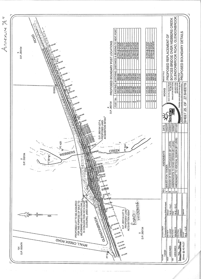
|
SINGLETON COUNCIL
|
Meeting of Singleton Council - 2 February 2009
|
|
|
|
|
|
Manager
Works Report No. 3/09
|
|
|
|
|
1.
|
Bitumen
Resealing Program
Author: Brendan Behringer
|
FILE: 02/0281
|
|
Detail:
Council will complete its Bitumen
Resealing Programme for 2008/2009 with the commencement of the Urban Streets
in late February 2009.
|
The bitumen and
aggregate surface acts as the wearing surface, reducing the rate of pavement
wear and maintenance costs by reducing surface moisture reaching the
pavement. It also improves the riding
qualities of the pavement as well as providing a safe, economical and durable
all weather surface.
Below is a listing of the Urban Streets to
be resealed.
Town Streets
|
Street Name
|
Location
From and To
|
|
Bourke Street
|
Campbell to Macquarie
St
|
|
Bourke Street
|
Macquarie to Elizabeth
St
|
|
Bourke Street
|
Elizabeth to Hunter
St
|
|
Bourke Street
|
Hunter to William St
|
|
Bourke Street
|
William to Pitt St
|
|
Bourke Street
|
Pitt to Castlereagh St
|
|
Bourke Street
|
Castlereagh to York St
|
|
Bowman St
|
0.00 to 0.026 from York St
|
|
Bowman St
|
0.026 to 0.093 from York St
|
|
Castlereagh Street
|
John to Bathurst St
|
|
Castlereagh Street
|
Bathurst to Church
St
|
|
Castlereagh Street
|
Church to George St
|
|
Combo Lane
|
0.22km to 0.36kmfrom Queen Street
|
|
Combo Lane
|
0.36 to 1.64km from Queen Street
|
|
Darlington Road
|
0.00 to 0.85km from Simpson Avenue
|
|
Elizabeth Street
|
John to George St
|
|
Hunter Street
|
John to George St
|
|
William Street
|
John to Church St
|
|
William Street
|
Church to George St
|
|
York Street
|
Church to John St
|
Singleton Heights Streets
|
Street
Name
|
Location
From and To
|
|
Acacia Circuit
|
0.06 to 0.94km from Bridgman Rd
|
|
Bailey Close
|
0.00 to 0.18km from Bridgman Rd
|
|
Gardner Circuit
|
0.00 to 1.29km from Bridgman Rd
|
|
James Cook Ave
|
Lawson to White Ave
|
|
Wentworth Avenue
|
Lawson to White Ave
|
|
Wentworth Avenue
|
Lawson to White Ave
|
|
FOR COUNCIL’S INFORMATION
|
Attachments
There are no attachments for this report.
|
SINGLETON COUNCIL
|
Meeting of Singleton Council - 2 February 2009
|
|
|
|
|
|
Manager
Works Report No. 3/09
|
|
|
|
|
2.
|
Works Program
Area Maintenance and Construction
Author: Brendan Behringer
|
FILE: 02/0281
|
|
Detail:
The Following works have been completed,
are in progress or are to be commenced by the Works Program Area.
|
a) Regional
Roads Improvement Program
|
Road
|
Location
|
Nature of Work
|
Status
|
|
Gresford Road (RR128)
|
7.00 to 7.55km from Redbournberry Bridge
|
Rehabilitation
of 550m section of existing road involving pavement widening, strengthening
and sealing.
|
100%
Complete.
|
|
Elderslie Road
|
11.88 to 13.13km from Cessnock City
Council Boundary (Branxton).
|
Rehabilitation
of 1250m section of existing road involving some realignment, pavement
widening, strengthening and sealing.
|
Stage 1 12.43 to 13.13km (last 700m) 25%
complete.
|
(b) Regional Roads Timber
Bridge Partnership
Program
|
Road
|
Location
|
Nature of Work
|
Status
|
|
Dunolly Road (RR7774)
|
Dunolly Bridge –
Western approach over flood way
|
Replacement
of existing timber spans on western approach with new concrete structure.
|
100% Complete.
|
(c) Local
Roads Improvement Program
|
Road
|
Location
|
Nature of Work
|
Status
|
|
Westbrook Road
|
5.00 to
5.70km from Mirannie Road
|
Rehabilitation
of 700m section of road involving pavement widening, strengthening and
sealing.
|
10% Complete.
|
|
Stanhope Road
|
9.00 to
9.78km from Elderslie Road
|
Rehabilitation
of 780m section of road involving pavement widening, strengthening and
resealing.
|
100%
Complete.
|
|
Bowman’s Creek Road
|
1.75 to
2.50km from Old Goorangoola Road.
|
Rehabilitation
of 750m section of road involving pavement widening, strengthening and
sealing.
|
10% Complete.
|
(d) Supplementary Roads to
Recovery
|
Road
|
Location
|
Nature of Work
|
Status
|
|
Old Carrowbrook Road
|
Franks Bridge
|
Construction
of a new concrete bridge to replace the existing timber structure.
|
Deck is
complete. On site construction to commence.
|
|
Hebden Road
|
Clydesdales
Bridge over Foy Brook
|
Construction
of a new concrete bridge to replace existing timber structure.
|
Deck is 70%
complete.
|
(e) Section
94 Contributions Projects
|
Road
|
Location
|
Nature of Work
|
Status
|
|
Hebden Road
|
Bridge over
Stringybark Creek
|
Construction
of a new concrete bridge to replace existing timber structure.
|
100% Complete.
|
(f) Kerb and
Gutter Program
|
Road
|
Location
|
Nature of Work
|
Status
|
|
Ryan Avenue
|
From the Sun
Dial to Burns Lane.
|
Install 350m
of kerb and gutter on the north western side of Ryan Avenue.
|
To commence.
|
(g) Other
Works
|
Road
|
Location
|
Nature of Work
|
Status
|
|
Carrowbrook Road
|
|
Construction
of unsealed section of road on correct road reserve alignment.
|
80% Complete.
|
(h) Country
Transport Passenger Infrastructure Grants
|
Road
|
Location
|
Nature of Work
|
Status
|
|
Simpson
Terrace
|
Intersection
with Allan Court.
|
Installation
of new Bus Shelter.
|
60% Complete.
|
(i) Flood
Damage Repairs
|
Nature of Work
|
Status
|
|
Damage claims
and permanent repairs. Estimates have been prepared for all roads and
approved by RTA.
|
Permanent
restoration works 90% complete.
|
(j) General Maintenance
Carried out on State Roads, Regional
Roads, Rural Local Roads and Urban Local Roads where required, including the
following:
|
Maintenance
|
Road/Street/Bridge
|
|
Sealed
Maintenance
|
Hebden,
Coachmens, Busby, Range, Middle Fallbrook, Lemington, Dights Crossing, Maison
Dieu, Wollombi, Goorangoola, Milbrodale, Rusty Lane, Summerhill and Fernhill
Roads.
|
|
Shoulder
Maintenance
|
Gresford and
Lemington Roads.
|
|
Roadside
Maintenance
|
Glendon,
Glendon Lane, Gresford, Hebden, Antiene, Gouldsville, Long Point, Scotts
Flat, Roughit Lane
and Mirannie Roads.
|
|
Reseal
Preparation
|
Regional
Roads 80% complete, Rural Local Roads 70% complete and Urban Roads to
commence.
|
|
FOR COUNCIL’S INFORMATION
|
Attachments
There are no attachments for this report.
|
SINGLETON COUNCIL
|
Meeting of Singleton Council - 2 February 2009
|
|
|
|
|
|
Manager
Works Report No. 3/09
|
|
|
|
|
3.
|
Minutes of
the Local Traffic Committee Meeting - 27 November 2008
Author: Michael Launders
|
FILE: 00/0002-3
|
|
Executive
Summary:
The minutes of the Singleton Local
Traffic Committee meeting held 27 November 2008 are detailed as Attachment 1.
|
|
RECOMMENDED that the minutes of the Singleton Local Traffic Committee meeting
held on 27 November 2008 be received and that the recommendations contained
within the minutes Formal Agenda Items be adopted.
|
Attachments
|
AT-1View
|
LTCM -
271108
|
27
Pages
|
|
Attachment 1
|
Manager Works Report No. 3/09
|
|
LTCM - 271108
|
Minutes of the Local Traffic
Committee Meeting - 27 November 2008
|
|
|
|
MINUTES
OF THE LOCAL TRAFFIC COMMITTEE MEETING HELD IN THE COUNCIL CHAMBER ON 27TH NOVEMBER 2008 COMMENCING AT 9.30 A.M.
PRESENT
RTA: Mr. I Jenkins. (Road Safety and
Traffic Officer)
Police: Sergeant R. Akerman,
(Traffic Officer, Hunter
Valley Local Area
Command.).
Local Member: Member for Upper
Hunter represented by Mr. R. Winter.
Council: Cr. A. Howlett, Mr. B.
Behringer (Acting Manager Works), Mr. S. Mackie (Trainee Engineer) and Mr. M.
Launders (Traffic Coordinator).
APOLOGY: None received
MINUTES:
Resolved, that the Minutes of the
Local Traffic Committee Meeting, held on the 19th February 2008 as circularized be
received and adopted.
(Winter / Akerman)
1. BUSINESS ARISING
FROM MINUTES OF PREVIOUS MEETING
1.1. QUEEN STREET FILE: RD 00915
Issue: Request for No Stopping parking
restrictions on the south side of Queen
Street from the vehicle entrance to number 9-11
(S.E.S. base) to the Singleton Crossing off-loading ramp junction with Queen Street.
Source: Membership of Singleton S.E.S. via Cr. Moore
Council’s Traffic Coordinator
asked the RTA representative when concurrence would be provided to Council for
the installation of parking restrictions recommended by the Committee at the 19th of February
2008 meeting.
The RTA representative indicated
his verbal consent. Council’s Traffic Coordinator then requested confirmation
of this consent in writing. The RTA representative then agreed to provide the
subject consent in writing.
To be Noted.
2. FORMAL AGENDA
2.1 GARDNER CIRCUIT
FILE: RD 0230
Issue: Hazardous anti social driving
practices in the partially developed area of Gardner Circuit.
Source: Council’s Traffic Technician and
Councillor Request Form No 1091.
It has come to Councils attention that hazardous anti social
driving is occurring in the partially developed section of Gardiner Circuit. A
resident of the affected section of Gardner Circuit contacted Council staff and
it appears from Councillor Request Form No 1091 of the 10th of June
2008 that Councillor Scott has also been approached on the same issue.
The affected section of Gardner Circuit is that section between
the northern most Bridgman Road
/ Gardner Circuit junction and Nicholas
Conoly Drive. This section is around 840 metres in
length and is still developing with the following features:
· New Dwellings under construction
· Vacant allotments
· Some recently occupied new
dwellings
· Further park construction at the Nowlan Park
retention basin.
· An abutting new subdivision.
(Pinnacle 6)
· Carriageway width of 13.0 metres.
The anti social behaviour reported consists mainly of speeding and
reckless driving by young drivers. Responses to approaches made to the police
services have not satisfied the affected residents.
As part of the Pinnacle Six
subdivision works a cycle / pedestrian refuge was constructed on the
carriageway of Gardner Circuit at Nowlan
Park and a footpath
constructed on the northern footway of Gardner Circuit. Future works in the
subject section of Gardner Circuit will include provision of more street
lighting.
It was initially thought that the anti social driving particularly
speeding would be limited by the installation of the cycle / pedestrian refuge.
However this facility has produced other hazardous driving by some east bound
vehicles which pass through the refuge on the incorrect side of the refuges
central median island. Since this was
reported a trial edge line and a barrier centre line have been installed. At
the time of the drafting of this report the line marking is still being
monitored to see what effect it has had on the anti social behaviour on the
approaches to the cycle pedestrian refuge island. The provision of such line marking should
make policing of road rules easier for the police service.
As the subject section of Gardner Circuit will function as part a
collector distributor road it will warrant centre line marking when the area
becomes fully developed. At this stage centre line marking between the northern
most Bridgman Road junction and Nicholas
Conoly Drive is warranted. Also adoption of the
trial edge lines at the pedestrian /cycle way refuge should also be
included.
In relation to the anti social driving Council will continue to
monitor the situation and where practical pass data onto the police service to
assist them in policing the problem. It is anticipated that as the area further
develops and becomes more built up the anti social driving will abate.
The Local Traffic Committee RECOMMENDS
that, to
cater for future traffic growth in the section of Gardner Circuit from the
northern most Bridgman Road junction to Nicholas Conoly Drive and to try and reduce anti social behaviour in
this section:
1. Appropriate
centre line marking be installed
2. The
trial edge lines on the approaches to pedestrian cycleway refuge, be,
confirmed.
3. Council continue to monitor the anti social driving behaviour and
pass relevant data onto the police service to assist them in policing the area
(Akerman
/ Jenkins)
2. YORK
STREET
FILE: RD 01530
DA 16 /2008
Issue: Traffic congestion with major
events at the Singleton Showground.
Sources: Councils Traffic Coordinator.
On the 19th to the 21st of February 2008 a
major mining equipment exhibition was held at the Singleton Showground. York Street in the Bathurst Street to Church Street block
became impaired with traffic congestion on the opening day of the event. The
same congestion was prevented on the second and third days by Council
intervention in the form of temporarily restricting parking on the northern
side of the subject block of York
Street.
Although there was off-street parking in the showground it was
insufficient to meet the demand, putting on-street parking in high demand also.
The event in question acquired Council approval via a DA
application.(DA 16/2008) However the planning process did not enforce the
condition that the event organiser provide a traffic plan prior to the event.
There is no record of a traffic plan in the subject DA file. The traffic assessment done in the statement
of environmental effects provided by the event organiser was superficial and
inadequate.
The accepted procedure for events now is to put the onus on the
event organiser to provide traffic facilities to cater for increases in traffic
volumes and parking. Other wise the Council or another
authority will be stuck with providing traffic facilities for the event. The
state government has published guidelines for event organisers and they include
requirements on traffic management and parking.
Council has traditionally provided on-street temporary traffic
facilities for the annual Singleton Show. However other organizations that hire
the showground, particularly corporate ones, for major events that will
generate excessive motor vehicle traffic should bear the responsibility for the
additional facilities to control the excess motor vehicle traffic.
During the mining exhibition notes were kept on problems in York Street being
experience by motor vehicles exiting the showground into York Street and congestion in the Bathurst Street to Church Street block
of York Street
which was caused by on-street parking on both sides of the carriageway.
To ease traffic congestion and to promote safer functioning of the
York Street
gate, Council staff considered some on-street parking restrictions near
them. The subject issue was raised in
communications with the showground association (N.A.A.) and they responded with
correspondence which supported the proposal and sought similar treatment at
other showground entrances.
In addition to the above correspondence communications to and from
the N.A.A. an on-site meeting was conducted with N.A.A., officials, on the 8th
August 2008. During this discussion the N.A.A. officials present raised no
objection to the imposition of on-street parking restrictions around the
showground entrances. However they did request an extra six metres of parking
restriction at the northern most Bathurst
Street gate with an exception for an official
N.A.A. vehicle to be used during major events in the risk reduction role and to
assist in the management of the showground entrances during the event.
To improve the functioning
and safety of all showground gateways, to ease traffic congestion in parts of York Street, Church Street and Bathurst Street
that abut the showground the following tables of parking restrictions should be
considered:
|
Permanent Parking Restrictions
|
|
Gate
|
Benefit
|
|
York Street
Permanent No Parking, parking restrictions on the southern side
of York Street
around the showground gate. (12 metres to the east , 6 metres to the west)
|
Aid entry and provide safe sight distance between vehicles
exiting the showground and vehicle travelling on York Street.
|
|
Church Street
Permanent No Parking, parking restrictions on the western side
of Church Street
around the northern most showground gate. (12 metres to the south , 6 metres
to the north)
|
Aid entry and provide safe sight distance between vehicles
exiting the showground and vehicle travelling on Church Street.
|
|
Bathurst Street
Permanent No Parking, parking restrictions on the eastern side
of Bathurst Street
around the southern most showground gate. (9 metres to the north , 6 metres
to the south)
|
Aid entry and provide safe sight distance between vehicles
exiting the showground and vehicle travelling on Bathurst Street.
|
|
Bathurst Street
Permanent No Parking, parking restrictions on the eastern side
of Bathurst Street
around the northern most showground gate. (12 metres to the north , 12 metres
to the south, 6 of which will be dedicated to an NAA official vehicle)
|
Aid entry and provide safe sight distance between vehicles
exiting the showground and vehicle travelling on Bathurst Street. Assist the NAA in
managing the annual show and other major events.
|
|
Temporary Parking
Restrictions
|
|
Restriction & Location
|
Benefit / Non
Benefit
|
|
York St: No Parking, parking restrictions on the northern side of
York Street
in the Bathurst
to Church Street
block for the duration of the major event.
|
Benefit
Allows through traffic to flow
freely in this block of York
Street.
Non
Benefit
In relation to on-street
parking residents of the northern side of the street will not be able to park
adjacent to their residences. They will have to park on the opposite side of
the street or off-street.
|
|
Church St 1: Temporary No Parking, parking restrictions on the eastern side
of Church Street north
from Dight Avenue
to the southern side of the vehicle entrance to No 20 for the duration of the
major event.
|
Benefit
Allows through traffic to flow
freely in this block of Church
Street. Particularly around vehicles waiting to
turn right into the showground.
Non
Benefit
.Loss of on-street parking on
the Church Street
frontage of No 2A Dight Avenue.
|
|
Church St 2: Temporary No Parking, parking restrictions on the eastern side
of Church Street north
from the vehicle entrance of No 30 to the vehicle entrance of No 26.
|
Benefit
Allows through traffic to flow
freely in this block of Church
Street. Particularly around vehicles waiting to
turn right into the showground.
Non
Benefit
Loss of on-street parking
between No 26 to No 30 Church
Street.
|
In relation to the dedication of a parking space dedicated to an
NAA official vehicle the police delegate requested that the vehicle bear some
sort of labelling to identify the vehicle as an official NAA vehicle and that
the same labelling also contain a
contact phone number.
The RTA delegate requested the addition of No Stopping parking
notices set at the standard statutory distances at the Church Street / Dight Avenue road junction.
The Local Traffic Committee RECOMMENDS that:
1.
To facilitate traffic flow in the Bathurst Street to Church Street block of
York Street during major traffic generating events at the Singleton Showground temporary
No Parking, parking restrictions as illustrated in the following drawing titled
“Traffic Control Plan for Temporary Parking Restrictions York St” be provided
on the northern side of York Street in the subject block for the duration of
the major event.
2. To
facilitate ingress and egress motor vehicle movements at Church Street, York
Street and Bathurst Street gateways to the showground permanent No Parking,
parking restrictions be provided as follows in the following table:
|
Parking
Restrictions Singleton Showground Gateways
|
|
Street
|
Side
of Street / Gate
|
Parking
Restriction
|
|
Church
|
West / Northern most
set of gates
|
No Parking from 12
metres south of the southern most, gateway of this set of gates to 6 metres
north of the northern most, gateway of this set of gates.
|
|
York
|
South / Mid block Bathurst to Church Sts
|
No Parking from 12
metres east of the gateway to 6 metres west of the gateway.
|
|
Bathurst
|
East / Northern most
gate
|
No Parking from 12
metres north of the gateway to 6 metres south of the gate followed by another
6 metres of No Parking with an exception for an appropriately labelled N.A.A.
vehicle.
|
|
Bathurst
|
East / Southern most
gate
|
No Parking from 9
metres north of the gateway to 6 metres south of the gateway.
|
3. To
facilitate turning movements into and from the Church Street showground gates
during the annual show and other major events the option to put in place for
the duration of the subject events the temporary traffic facilities as follows and as illustrated in the following
drawing titled “Traffic Control Plan for Temporary Parking Restrictions Church
St”, be supported:
(i Temporary No Parking,
parking restrictions on the eastern side of Church Street north from Dight
Avenue to the southern side of the vehicle entrance to No 20 for the duration
of the major event.
(ii Temporary No Parking,
parking restrictions on the eastern side of Church Street north from the
vehicle entrance of No 30 to the vehicle entrance of No 26.
4. The onus for providing additional on-street
traffic facilities for major events at the Singleton Showground be placed upon
the event organiser with the exception, being, the annual Singleton Show.
(Akerman
/ Jenkins)


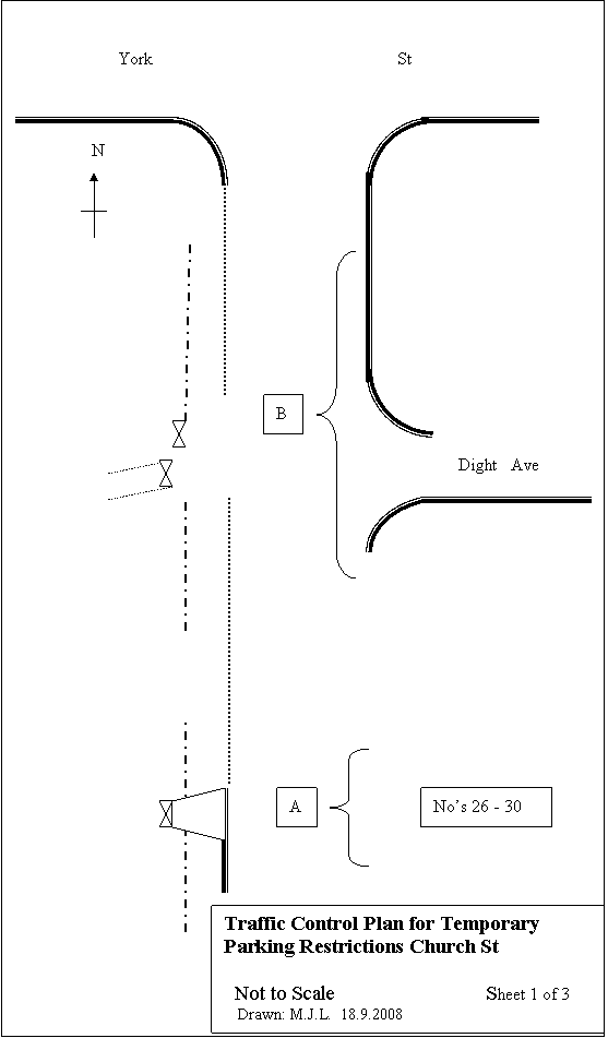


3. PATRICK
STREET FILE:
RD 01380
Issue: Request for school hours parking
restrictions on the eastern side of Patrick
Street from Queen Street to Market Street.
Source: Parents and Friends Association
Saint Catherine’s Catholic
College.
The President of the Parents and Friends Association Saint
Catherine’s Catholic
College wrote to council
requesting that No Parking, parking restriction effective between 8.00am to
9.30 am and 2.30 pm to 4.30pm be, provided on the eastern side of Patrick Street
between Queen Street
and Market Street.
The reasons given for this request were as follows:
· During high levels of peak period
traffic vehicles parked on – street cause on- street congestion which impedes
traffic flow along the street including school buses.
· The above congestion results in
safety issues for vehicles and young pedestrians due to sight distance
restrictions resulting from inappropriately parked cars.
In investigating this matter the following table of inspection and
surveys were carried out by Council’s traffic staff:
|
Surveys Patrick
Street
|
|
Date / Day
|
Time
|
Survey /
Observation
|
|
31.7.2008 / Thurs
|
2.51 pm to 3.25pm
|
Observed functioning of Patrick St and took notes.
|
|
1.8.2008 / Fri
|
8.43 am to 9.02 am
|
Observed functioning of Patrick St and took notes.
|
|
4.8.2008 / Mon
|
2.35 pm to 3.30 pm
|
Off –street car parking survey.
|
|
6.8.2008 / Wed
|
2.45 pm to 3.15 pm
|
Observed access / egress point of St Catherine’s junior school.
|
From the above surveys and observations the following was noted or
concluded:
· The system provided by the school
for vehicles to deposit and pick-up school students is situated in a private
off-street car park that abuts the school. This car park will be referred to as
Saint Patrick’s Car Park in this report. The ingress and egress to this car
park is from and to Patrick Street.
The majority of parent’s use this system in depositing and picking up their
children. Some however use Patrick
Street for these activities. It was also noted
that on some occasions the off-street car park does not have the capacity to
cater for all parents vehicles forcing some to park on street. This situation
was witnessed during the 31st July survey. If on-street parking has
to occur it is better that the eastern side of Patrick Street is favoured as the trip to
and from the school grounds does not involve the crossing a carriageway.
Because Saint Patrick’s Car Park does not have defined parking bays it will
never reach its full potential in storing parked vehicles.
· The worst situation occurs in the
afternoon peak as departures from the school are concentrated into a short time
span. While in the morning arrivals at the school are staggered so not all
vehicle arrivals and departures are concentrated into the same short time
period.
· Some on- street parking on Patrick Street in
the vicinity of the vehicle ingress / egress point are obstructive to exit and
entry movements from and into the off-street car park.
The following table of traffic facilities is put forward as means
to address the problems raised by the Parents and Citizens:
|
Proposed Traffic Facilities Patrick St
|
|
Facility
|
Location
|
Benefit
|
|
1. Extend No Stopping parking restriction by 2.5 metres.
|
Patrick St. West side south of Kent St.
|
Better sight distance to Kent St junction
Lessen convenient on – street parking may encourage use of
off-street parking.
|
|
2. Provide No Stopping parking restriction. 31.9 metres in
length
|
Patrick St. East side across egress
/ ingress point to off-street car park.
|
Better sight distance to and from egress / ingress point should
facilitate safety of entry and exit movements and also expedite these
movements.
|
|
3. Provide school times No Parking, parking restriction.
|
Patrick St. East side south of No
Stopping restriction proposed in “2” above.
|
Provide a convenient location for dropping off older students.
(includes high school students who take younger siblings to junior school)
|
|
4. Provide appropriate centre line markings
|
Patrick St. Each approach to
ingress / egress point of off –street car
park
|
Assist in prevent illegal parking and assist ingress and egress
of off –street car park.
|
|
5. Provide appropriate centre line markings
|
Kent Street for 9 metres from Patrick St.
|
Assist in prevent illegal parking to close to the Patrick St.
junction.
|
PATRICK ST
/ KENT ST
N T S
Drawn: M.J.
L. 19.11.2008
|
|
The Local Traffic Committee RECOMMENDS that, to facilitate both pedestrian safety and vehicle
movements to and from the Patrick Street access point to Saint Catherine’s
College the following traffic facilities,
described in writing and graphically represented in a graphic titled
“Patrick St / Kent Street “be provided:
1. Extension of the existing No Stopping
parking restriction on the western side of Patrick Street, south of Kent
Street, by 2.5 metres southwards.
2. Provide
a No Stopping parking zone, 31.90 metes long, across the vehicle ingress /
egress point of St Patrick’s car park.
3. Provide a school hours No Parking zone on
the eastern side of Patrick Street
for a distance of 11.5 metres from the existing No Stopping notice south of Kent Street.
4. Provide an appropriate length of painted
centre line on the Patrick Street
carriageway on each approach to the vehicle ingress / egress point of Saint
Patrick’s Car Park.
5. Provide a barrier, barrier centre line on
the Kent Street
carriageway for a distance of nine metres from Patrick Street.
(Howlett
/ Jenkins)


4. WALLABY SCRUB ROAD FILES: DA 5/2006
M9 - 4
RD 00090
Issue: Objection on safety grounds to road
alterations brought about by railway works on Wallaby Scrub Road near the entrance to
No 683.
Sources: 1.Cec M Hawkes Pty Ltd.
2. Director – General,
NSW Department of Planning.
The road environment around the entrance to No 683 “Springwood”
which fronts Wallaby Scrub Road
was changed with the construction of the railway line to Warkworth. Mr R. Hawkes, Managing Director of Cec M.
Hawkes Pty Ltd the owner of “Springwood’ claims that the rail works had an
adverse impact on the ingress / egress point to “Springwood”. Mr. Hawkes is
currently in dispute with Wambo Coal Pty Ltd. on this issue.
.Mr Hawkes claims that the rail works on Wallaby Scrub Road adversely affected his
access / egress in the following ways:
(a.) Reduction
in off- carriageway distance between the edge of the carriageway and the
gateway to “Springwood”.
(b.) Guardrail
associated with the rail project provided on the eastern side of Wallaby Scrub Road
prevents south bound through vehicles passing a vehicle turning right into
“Springwood” on the left hand side of the turning vehicle.
(c.) Guardrail associated with the rail
project provided on the western side of Wallaby Scrub Road prevents north bound
vehicles leaving “Springwood” from using the road shoulder to accelerate before
entering the carriageway.
Earlier this year Insite Planning Engineering Environmental was
engaged by Wambo Coal Pty. Ltd. on the instruction of the N.S.W. Department of
Planning, to prepare a Road Safety Assessment of the existing access to No 683,
“Springwood”,
Wallaby Scrub Road.
The key finding of the Insite Planning assessment are listed as
follows:
1. The rail works carried out in 2005 / 2006 have adversely affected
the safety of the access point to No 683 Wallaby Scrub Road.
2. The main impact being a reduction in length between the gate
structure of No 683 and the carriageway of Wallaby Scrub Road.
3. Guardrail provided at the rail overpass has limited the ability of
Mr Hawkes to use the western road shoulder of Wallaby Scrub Road from his property gate
as an acceleration area before entering the carriageway of Wallaby Scrub Road.
4. Low through traffic volumes on Wallaby Scrub Road and low turning
volumes into No 683 do not warrant turning treatments for vehicles entering No
683.
5. A stopping sight distances from to the entrance point of No 683
are considered adequate for the posted speed limit of 80km/h.
6. Concern about the speed of vehicles on Wallaby Scrub Road in the vicinity of No
683. Recommends a request be put to the police via the local traffic committee
for remedial action via enforcement of the existing 80km/h speed limit.
7. The proposal by Singleton Council:
· To set the property access gate further away from the
carriageway to allow long vehicles to stand off the carriageway while the gate
is operated.
· To provide driveway warning signs and to trim vegetation on
Wallaby Scrub Road
to the south of the access gate.
8. The proposal in “7.” above was, supported
with a minor increase to the turning radius to cater for long vehicles turning to
and from the subject access.
On Tuesday 5th August 2008 the subject site was visited
and the following observations were recorded:
· Sight distances tests from the
ingress /egress point of “Springwood”.
· The quality and location of the sign posting of the 80 / 100 speed zone
change point on Wallaby Scrub Road plus other traffic facilities between the
start of the 80km/h speed zone and the existing ingress / egress point of
“Springwood”.
On Wednesday the 13th August 2008 a random speed survey
was conducted at a location 140 metres south of the entrance to “Springwood”.
The survey was carried out between 10.41 am and 11.45 am. . This survey
indicated that the existing 80km /h speed limit was being exceeded by the
majority of vehicles surveyed. The survey
results are summarised in the following table:
|
Random Speed Survey
683Wallalby Scrub Road
|
|
Date / Time
|
North Bound
|
|
|
Wed 13.8.2008
|
Vehicles Surveyed: 12
|
12
|
|
10.41 -11.45
|
Vehicles Exceeding Speed Limit
|
8
|
|
|
Range of Speeds
|
66.05 – 96.00 km/h
|
|
|
|
|
|
Date / Time
|
South Bound
|
|
|
Wed 13.8.2008
|
Vehicles Surveyed: 7
|
7
|
|
10.41 -11.45
|
Vehicles Exceeding Speed Limit
|
6
|
|
|
Range of Speeds
|
67.89 – 116.12 km/h
|
In relation to north bound speeding vehicles on Wallaby Scrub Road improvements to the
notices which introduce the speed limit may give more credibility to the 80km/h
speed limit. This in turn may produce better compliance with the same speed
limit.
Also the recommendation to have the Local Traffic Committee
develop a strategy with the police to reduce the problem of speeding appears to
be not the most practical way to treat the problem of speeding. As traffic volumes are low as indicated in
the summary of the speed survey, where 23 vehicles passed through the subject
section of Wallaby Scrub Road
in one hour. Putting police there could be seen as a waste of resources
particularly when the problem can be engineered out. Also the police solution
would only be in place infrequently, whereas an engineering solution would be
of a permanent nature.
By simply relocation the entrance point by around 100 metres to
the south the sight distance to the south can be improved to the extent to
allow safe exiting from “Springwood.” in a 100km/h environment.
The Local Traffic Committee RECOMMENDS that, to improve road safety at the entrance to No
683 Wallaby Scrub Road the following measures be taken:
1. To
facilitate sight distances from the entrance the parties involved in dispute
consider relocating the existing entrance point to a location to the south that
has improved sight distances.
2. To
facilitate large vehicle access to the subject property the parties involved in
dispute consider that the existing gate or any relocated main gateway be
recessed in to the subject property to allow a semi trailer sufficient room to
safely stand between the edge of the
carriageway and the gate while the gate is operated.
3. The
existing 80km speed notices that introduce the zone be upgraded and
complemented with appropriate speed zone pavement numeral.
(Akerman
/ Winter)
5. RURAL
T JUNCTIONS
FILE: RD 00026
Issue: Need for a further traffic
facilities on rural T junctions with deficient sight distance along the
terminating road to the through road.
Source: Council’s Traffic Technician.
On the 26th June 2008 Council staff discovered a severely damaged
sight screen in Dyrring Road
at the Pioneer Road
/ Dyrring Road
junction. Upon inspection of the site sufficient evidence was observed to
indicate that the sight screen had been damaged by a vehicle impact.
The offending vehicle had been travelling east on Pioneer Road and
overshot the termination point of this road where it junctions with Dyrring Road to
collide with the site screen opposite the terminating road (Pioneer Rd). This incident occurred in
spite of a T junction warning sign in good order on Pioneer Road some 200 metres prior to its
junction with Dyrring Road.
What may have contributing factor to this accident incident was
the loss of sight distance to the road junction experienced by vehicles on Pioneer Road as they come into
the subject road junction. This sight distance loss, results from the under
vertical curve on Pioneer Road
prior to the junction. This feature is presented graphically in the following
figure:
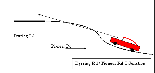

This site and other similar junctions within the Singleton Local
Government area have the following traffic facilities:
· A sight screen on the through
road, where possible, located directly opposite the terminating road.
· A T junction warning signs on the
terminating road prior to the junction.
Further highlighting of the termination of roads where deficient
sight distance exists on the terminating road may be achieved by the provision
of a barrier centre line on the terminating road from the road junction down
the terminating road for an appropriate distance.
At this point in time the following table of road junctions are
known to have degrees of defective sight distances on the terminating road that
is not centre line marked:
|
T Junctions
|
|
Road Junction
|
Terminating Road
|
Existing
Traffic Facilities
|
|
Pioneer Rd / Dyrring Rd
|
Pioneer Rd
|
Sight screen, T junction
warning sign
|
|
Brig.
Hammett Rd / Retreat Road
|
Brig Hammett Rd
|
T junction warning sign.
|
The Local Traffic Committee RECOMMENDED that, to decrease the likely incidents vehicles
running through a road T junction from the terminating road, the following
treatment, be adopted at existing road T junctions where a sight distance
deficiency to the junction exists on the terminating road:
1. Appropriate
barrier centre lines, be provided on the terminating road, to highlight the
fact that a road is terminating.
2. Duplication
of T junction warning signs, in size B, on the terminating road.
3. Providing
the larger size of sight screen where the practicalities of the site allow the
installation of such a size.
(Jenkins / Akerman)
6. LONG POINT ROAD
FILE: RD 00124
Issue: Need to provide barrier centre
line on existing line marking on a sight distance deficient horizontal curve Long Point Road.
Source: Council’s Traffic Technician.
The initial section of Long
Point Road where it leaves the Golden Highway consists of a short
straight followed by a right hand horizontal curve which is then followed by a
long straight. These features are
presented graphically in plan view in the following figure titled “Location Sketch Plan Long Point Road.
The horizontal curve referred to above and illustrated in the figure is
deficient in overtaking sight distance and the line marking needs to be amended
to allow for this.
The present centre line marking around the subject curve is a
separation line which in theory allows vehicle to overtake. Sight distance test
was conducted from the end of the existing barrier, barrier line preceding the
curve and found to be deficient for the posted speed limit of 100 km/ h. To rectify this situation the existing
separation centre line commencing at the termination of the existing barrier,
barrier line will require:
· Sixty metres to be converted to
barrier, barrier line and then;
· A further 216 metres converted to barrier, separation line.
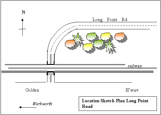

The Local Traffic Committee RECOMMENDS that, to deter hazardous overtaking on Long Point
Road on the first horizontal curve north of the Golden Highway the:
1. Existing barrier,
barrier lines, be extended by 60 metres.
2. Existing
separation lines following the barrier, barrier lines extension in the above
recommendation, have 216 metres converted to barrier, separation line.
(Winter / Howlett)
7. SIMPSON
TERRACE
FILE: RD 02570
Issue: Need for a formalised bus stop
on Simpson Terrace at a proposed bus shelter site.
Source: Council’s Community Grants Project
Officer.
Council is proposing with the help of the state government to
provide a public transport facility (bus shelter) on the western side of
Simpson Terrace, immediately north of Allen
Court in the residential suburb of Darlington.
The proposed site at Darlington
also coincides with the pedestrian path from the residential community on the
northern side of the New England
Highway. At this location the proposed bus stop
can be accesses by parties who reside on the northern side of the highway as
well as Darlington residents on the southern
side of the highway.
From the traffic point of view the proposed site is adequate as
the carriageway of Simpson Terrace is in the order of 12 metres wide at this
location so a bus stopping at the kerb will not impede other through traffic.
The site is also in an area that has street lighting.
The Local Traffic Committee RECOMMENDS that, as the subject site in Simpson Terrace, for
the proposed public transport facility (bus shelter), appears well suited for
such a facility the facility be complemented by the provision of appropriate
regulatory bus stop traffic facilities in the form of a signposted Bus Zone, as
illustrated below, to prevent inappropriate on-street parking at the bus stop.


8. KIRKTON ROAD FILE:
RD 00044
Issue: Request for treatment of a crest
near, Rural Address No.103, Kirkton
Road, approximately 4.8km from the New England Highway,
to reduce its potential as a road safety hazard.
Source: Mr Sam Mackie, Trainee Engineer,
Singleton Council.
An audit of Kirkton
Road after recent works to bitumen seal the final
section of gravel pavement revealed a deficiency in sight distance on the
approaches to the subject crest.
Kirkton Road at the subject site
consists of a straight piece of road in the horizontal sense while in the
vertical sense it consists of an over vertical curve or crest. The subject road site in its current form has
the physical and other features as tabulated below:
|
Feature
|
Data Relative To Feature
|
|
|
|
|
Carriageway Pavement
|
6.25 m wide bitumen sealed pavement
|
|
Alignment
· Horiz.
· Vert.
|
Relative straight
Crest
|
|
Traffic controls
|
“100” km/h speed limit.
|
|
Traffic Volume
|
In the order of 81 vehicles per day.
|
|
Responsible Authority
|
This road is under the care and control of the Singleton Council
|
|
Accident Incidents
|
Nil
|
A sight distance test at the subject crest based on two vehicles
approaching the crown of the crest simultaneously from opposite directions
resulted in them both having to be both within 27 metres of the crown of the
crest before they could see each other.
If both vehicles in this situation were travelling at 100km/h (27m/s)
and one was on the incorrect side of the carriageway they would collide in one
second.
Methods to rectify this deficient sight distance could be:
1. Vertical realignment of the carriageway by lowering the crest.
2. Provision of traffic facilities such as
centre line marking and sign posting.
Option “1” would be a long term option due to the proximity of
private property vehicle access points and the scale of work required to
improve sight distance. Also land
acquisition may be necessary in this option. This option will bear great costs
and will see a brand new pavement excavated.
For the present time option “2” presents itself as the most
expedient way to treat the hazardous aspect of deficient vehicle to vehicle
sight distance on the approaches to the subject crest.
The
Local Traffic Committee RECOMMENDS that to reduce the
potential of a head-on vehicle to vehicle conflict on Kirkton Road at the crest
“near RA 103 appropriate centre line markings be provided on the approaches to
the crest.
(Winter
/ Akerman)
3. INFORMAL AGENDA ITEMS (For Determination by
the RTA)
1. NEW ENGLAND H’WAY
FILE: RD 00900
DA 410 /2004
Issue: Demand for No Standing parking
restrictions on the New England
Highway at the Rugby League football ground in
Dunolly.
Sources: Council’s Manager Parks
and Facilities.
At its Corporate and Development Services Committee Meeting on the
11th October 2004 the Council approved DA 410 / 2004, being a
development application for a rugby league football complex. Approval condition “27” read as follows:
“27. PEDESTRIAN AND VEHICULAR ACCESS- shall be denied from the New England Highway
by the provision of fencing and landscape screening. The fencing shall be of
sufficient height to ensure footballs do not enter the New England Highway. No standing signage
shall be provided along the New
England Highway frontage of the site. Full details
shall be submitted to and approved by Council prior to the release of the
Construction Certificate for the civil works.”
This particular report shall focus on the parking restrictions
aspect of condition “27”.
In correspondence dated the 13th September 2004 the RTA
commented that:
“Appropriate fencing/ screening should be provided to ensure that
footballs do not project onto the highway and spectator vehicles do not park on
the highway reserve. ‘No standing’ signs may be required on the New England Highway.”
On Sunday the 3rd of August 2008 the subject site on
the highway was surveyed for a period of 30 minutes while a rugby league match
was in progress. Between, 2.51 pm and 3.21 pm no vehicle pulled onto the
highway verge to view the rugby league match however five vehicles did stop on
the highway verges and the occupants alighted to view motor vehicles displayed
for sale on the southern verge of the highway. This survey is graphically
presented in the following table titled, “Vehicles Stopping on Verges New England Highway Dunolly”.
|
Vehicles Stopping on Verges New England Highway Dunolly
|
|
Date: Sun 3.8.2008
|
Verge
|
|
Time
|
Northern
|
Southern
|
|
2.51 pm – 3.06 pm
|
0
|
0
|
|
3.06
pm – 3.21 pm
|
3
|
2
|
It was also noted at the time of the survey that a gap in the
highway verge tree vegetation allows a view of the football field from the
highway.
The fear that people would use the highway verge to view rugby
league matches does not appear to be substantiated and under these
circumstances parking restrictions do not appear to be warranted.
The Local Traffic Committee RECOMMENDS that, as no evidence has been presented to identify
that parties are viewing rugby league matches from the New England Highway verge, that abuts the
rugby league ground, parking restrictions not be provided.
(Akerman / Howlett)
2. WATTLE
PONDS SPEED ZONING FILE: RD 00067
RD
07510
RD
07560
RD
07570
Issue: Need for a clarification of
speed limits on Pioneer Road,
Brigadier Hammett Road,
Morris Road
and Nawaday Way
Source: Council’s Traffic Technician.
With both rural residential growth and urban growth some roads in
the Wattle Ponds area lack clarity in terms of speed limits. The roads affected
are Pioneer Road
, Brigadier Hammett Road,
Nawaday Way
and Morris Road.
It is possible to enter
these roads at one end under a certain speed limit and emerge at the other end
into a totally different speed limit. There is no clear change point. The roads
that feature or play a part in this matter are detailed in the following:
1. Table titled “Speed Zoning Wattle Ponds.”
2. Sketch plan titled “Existing Speed Zones
Wattle Ponds”.
|
Speed Zoning Wattle Ponds
|
|
Road
|
Section
|
Posted Speed Limit
|
|
Bridgman Rd
|
South of northern most Gardner Cir junction
|
60
|
|
Bridgman Rd
|
North of northern most Gardner Cir junction
|
80
|
|
Retreat Rd
|
Entire length
|
70
|
|
Wattle Ponds Rd
|
Entire length
|
60
|
|
Brigadier Hammett
Rd
|
Entire length
|
60 at north end only
|
|
Nawaday Way
|
Entire length
|
Not posted
|
|
Morris Rd
|
Entire length
|
60 at north end only
|
|
Pioneer Rd
|
Entire length
|
Not posted
|
|
Dyrring Rd
|
Entire length
|
100
|


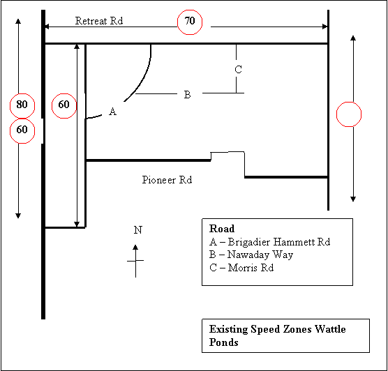

This issue needed clarification and referral to the RTA who has
sole authority in the allocation of speed zones. At the time of the drafting of
this report correspondence on this matter was also forwarded to the RTA.
The RTA responded, advising that it would apply the following
speed limits as detailed in the following table:
|
Proposed Speed Limits at Wattle Ponds
|
|
Street / Road
|
From
|
To
|
Proposed Speed Limit Km/h
|
|
Pioneer Rd
|
Wattle Ponds Rd
|
Allsop Pl
|
50
|
|
Pioneer Rd
|
Allsop Pl
|
Dyrring Rd
|
80
|
|
Wattle Ponds Rd
|
Bridgman Rd
|
Pioneer Rd
|
50
|
|
Wattle Ponds Rd
|
Pioneer Rd
|
Retreat Rd
|
Remain at 60
|
The Local Traffic Committee RECOMMENDS that, the clarification of speed limits on roads in
the Wattle Ponds area as detailed in the RTA’s correspondence which advised of
proposed new speed limits be noted.
(Jenkins / Akerman)
3. MAITLAND
ROAD
FILE: RD 00898
Issue: Request for segregated turning
lanes for north bound traffic on Maitland
Road at the York Street / Boundary Street / Maitland Road / George Street intersection.
Sources: Councillor Scott via Councillor
Request Form No 1094 of 11.08. 2008.
Councillor Scott filed a request from a group of local bus drivers
to have the north bound left lane on Maitland
Road at York
Street made an exclusive left turn only lane. It
was requested that this be put into practice by appropriate pavement arrows and
appropriate signs.
The desired layout of the subject north bound is illustrated below
in the sketch plan titled “Segregated Traffic Lanes Maitland Rd” In making the
left lane left turn only the other possible traffic movements (through traffic
and right turning traffic) have to be conducted from the right hand lane. The
provision of a left turn pavement arrow
and or a sign dictating that the left lane must turn left
obligates drivers in the lane to which these just mention traffic facilities
are applied to turn left. To disobey such a pavement arrow of sign is an
offence under the “Australian Road Rules”(Rules 88 and 92).
The logic for providing this treatment is to prevent through
traffic using the left lane as an overtaking lane. In some instances this
manoeuvre is executed at speeds bordering on the speed limit (60 km/h) and at
times these vehicles have to merge back into the through lane rapidly to avoid
parked vehicles on the western side of George Street.

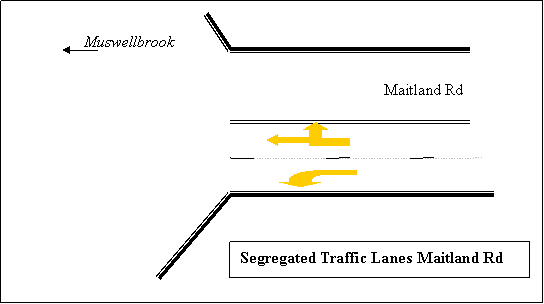

It must be pointed out that the right turn into Boundary Street
from Maitland Road is carried out by
8.14% of the total volume of traffic heading north on Maitland Road. Under the
current arrangement at the subject location where the two north bound lanes are
not segregated into particular movements it is possible for through traffic to
enter the left lane and pass a vehicle waiting to turn right into Boundary
Street. If through motorists are restricted from doing this it most likely will
cause delays and congestion on Maitland
Road for through traffic. These delays would most
likely be a source of complaint. The just described situation is illustrated
below in the sketch plan titled “N.E.H. Traffic Movements Maitland Rd. and George St.”
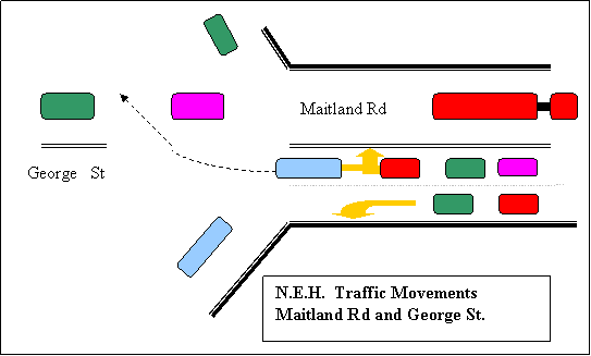

Traffic volumes for various
manoeuvres of the subject direction of traffic flow during the am and pm peak
times are detailed in the following table:
|
Manoeuvres of North Bound Traffic Maitland Rd
at York St
|
|
Movement
|
AM
Peak
|
% of
Total
|
|
PM
Peak
|
% of Total
|
|
Right into Boundary
|
66
|
8.14
|
|
38
|
4.81
|
|
Straight through
|
644
|
79.50
|
|
676
|
85.67
|
|
Left into York
|
100
|
12.34
|
|
75
|
9.50
|
|
Opposing Traffic Heading South
|
|
Through from George
|
476
|
|
|
900
|
|
|
Data Source
|
PB
Singleton Traffic and Parking Study and Plan. July 2007.
|
|
|
|
|
|
|
|
Also the road authority for the New England Highway,
the RTA, may not permit the requested treatment due to the likely delays to
north bound highway traffic.
The Local Traffic Committee RECOMMENDS that, the matter of segregating north bound New
England Highway traffic on Maitland Road at York Street into one lane for left
turns into York Street only and one lane for through traffic to share with
right turning traffic be referred to the RTA with a request that this issue be
included in a review and assessment relating to the entire operation of the
subject intersection.
(Winter / Howlett)
4. INFORMAL DISCUSSIONS (For
Information only)
1. BROKE
FILE:
Issue: Speeding through Broke Village
and the surrounding district.
Source: Ms. S. Leaf, 38 Howe Street, Brole via the police
delegate.
The
police delegate tabled a of correspondence, dated 23.11.2008, from Ms. Leaf.
From the correspondence it
appears that Ms Leaf has been conducting a campaign against speeding through
Broke village and on surrounding roads. She has been active in reporting
speeding instances to the police as well as approaching local mining companies
about speeding by their employees.
Ms Leaf expressed frustration
about the non-cooperative attitude of most large mining companies and the level
of patrolling by highway patrol police. However some credit was given to some
contractors who provide services to the mining industry and to one mining
company.
To be Noted.
2. RACECOURSE LANE / NEW ENGLAND H’WAY FILE:RD 00900
Issue: Proposed traffic changes at the Racecourse Lane /
New England Highway Intersection as part of the rail third track project.
Source: Cr. A. Howlett.
On behalf of residents of Racecourse Lane, Neotsfield Lane and
Kanona Lane,
Whittingham, Councillor Howlett expressed concern about the published design of
the Racecourse Lane
/ New England Highway
intersection.
The published design contained
features which would increase the degree of hazard and difficulty for entering
and leaving Racecourse Lane
when leaving and merging into the highway.
Cr. Howlett also expressed
disappointment that an attempt to have a meeting of residents with the RTA had
not eventuated.
However the Acting Manager Works
advised that he had set up a meeting with the RTA and Council staff on this
issue and the concerns of the Whittingham residents would be on the agenda of
the Council staff attending this meeting.
To be Noted.
Meeting closed at 11.15 am


M
LAUNDERS
TRAFFIC
COORDINATOR
|
SINGLETON COUNCIL
|
Meeting of Singleton Council - 2 February 2009
|
|
|
|
|
|
Manager
Works Report No. 3/09
|
|
|
|
|
4.
|
Naming of
Un-named Lane between Putty Road
and Army Camp Road
to Heuston Lane
Author: Michael Launders
|
FILE: 01/0505
|
|
Executive
Summary:
At its Operations Committee Meeting on the 3rd November 2008 the Council adopted
the following recommendations in relation to naming an unnamed lane at
Glenridding:
1. “The un-named lane that leaves the Putty Road near No 283 and heads in an
easterly direction until it junctions with the Army Camp Road near No 194 be named Heuston Lane.
2. This road naming be implemented
as per the procedures in the Roads Act 1993 which includes advertising the
naming proposal for public comment.”
(minute 335/08)
|
Background:
See the attached copy of the original report on this matter which
was presented to the Operations Committee on the 3rd November 2008 (Attachment 1).
Management Plan:
Not applicable.
Council Policy:
Not applicable.
Legislation:
Roads Act
1993 as amended (“PART 10 Division 4)
Sustainability:
Social:
Help the public who are trying to
access an address in the subject lane. This may result in less frustration for
the public and parties servicing addresses in the lane.
Environmental:
In describing the lane in future
written reports, orders etc. two words will describe the lane rather than a
long description. This will use less, resources.
Financial:
A street name at this location will assist service businesses to
locate rural residences and rural work sites that front the lane. The expense
to Council will be the provision and maintenance of a street name blade
structure.
Consultation:
Consultation
as required by the road naming process was carried out. Consultation was as
presented in the following table:
|
Consultation Proposed Road Name Heuston Lane
|
|
Method
|
To / Via
|
Date
|
|
Correspondence
|
Dept of Lands
|
4.12.2008
|
|
Correspondence
|
Land Titles Office
|
4.12.2008
|
|
Correspondence
|
Aust. Postal Commission
|
4.12.2008
|
|
Correspondence
|
NSW Ambulance Service
|
4.12.2008
|
|
Correspondence
|
NSW Police
|
4.12.2008
|
|
Correspondence
|
State Emergency Service
|
4.12.2008
|
|
Correspondence
|
NSW Fire Brigades
|
4.12.2008
|
|
Correspondence
|
NSW Rural Fire Service
|
4.12.2008
|
|
Advertisement
|
Singleton Argus
|
14.11.2008
|
One
response to the above consultation was received via correspondence from the
Department of Lands. This correspondence advised that the Department had no
objection to the proposed road naming.
Risk Management:
In
emergencies a formal name for the lane will be a benefit to emergency services.
Options:
In relation to this matter there
are two options:
1. Council can not proceed to carry out the final formal process
in making the name official and let the status quo remain.
2. Council proceed with the final formal
requirements of the naming process and make the name official.
Conclusions:
As the Council has already
adopted a recommendation to name the subject road Heuston Lane and no party has objected to
it, the naming should now be finalised by executing the final formal
requirements to make the proposed name official.
|
RECOMMENDED that Council:
1. Confirm its resolution of the 3rd November 2008
to name the un-named lane that leaves the Putty Road near No. 283 and heads
in an easterly direction until it junctions with the Army Camp Road near No.
194 be as Heuston Lane.
2. Proceed with the
final formal requirements in formalising the name Heuston Lane.

Gary Woodman
Brendan Behringer Brian Carter
Acting
Manager Works Acting
Director Operations
|
Attachments
|
AT-1View
|
RTC
Report 11/08
|
5 Pages
|
|
Attachment 1
|
Manager Works Report No. 3/09
|
|
RTC Report 11/08
|
Naming of Un-named Lane between
Putty Road
and Army Camp Road
to Heuston Lane
|
|
|
|