NOTICE OF MEETING
Notice is hereby
given, in accordance with the provisions of the Local Government Act 1993 that
a Meeting of the Corporate and
Development Services Committee will be held in the Council Chambers, Queen
Street Singleton, on Monday 13
September 2004, commencing at 5:30 pm.
AGENDA PAGE
Apologies
Confirmation of Minutes
1. Corporate and
Development Services Committee 9 August 2004
Mayoral Minute
Disclosures
and Declarations of Interest
Withdrawal
of Items and Late Items of Business
Presentations
Ashton
Coal Operations Pty Limited
Public
Access Session
General Manager's Report No. 14/04
1. Upper
- Northern Hunter Regional Environmental Management Strategy.............................. 5
Economic Development Officers
Report No. 6/04
1. Economic
Development....................................................................................................... 9
Director
Corporate and Development Services Report No. 23/04
1. 2003/2004
Annual Financial Reports................................................................................. 11
Manager Planning
& Development Report No. 10/04
1. Road
Naming of Subdivision Road.................................................................................... 17
2. Newcastle Sports
Parachute Club Community Consultative Committee (NSPC CCC)....... 23
3. Rural
Residential Development Strategy - Steering Committee............................................ 27
4. Questions
Without Notice.................................................................................................. 28
5. Subdivision
- 14 Allotments............................................................................................... 29
6. Water
Quality Monitoring Program.................................................................................... 65
7. United
Coal Mine CCC..................................................................................................... 67
8. Minutes
of Glennies Creek Community Consultative Committee......................................... 68
9. Hunter Valley
Operations CCC......................................................................................... 72
10..... Camberwell Coal Community Consultative Committee.................................................. 77
11..... Minutes of Liddell Coal Mine Community Consultative
Committee Meeting................... 82
12..... Minutes of Ashton Coal Mine Community Consultative
Committee Meeting................... 87
Questions
Without Notice
…………………………………………..
GENERAL
MANAGER
Singleton
Council’s Vision Statement is:
“Singleton. A progressive
community of excellence and sustainability”
Singleton
Council’s Mission Statement is:
“To provide quality services to the community in an
efficient and friendly manner encouraging responsible development”
Singleton
Council’s Core Values are:
|
|
Value
|
Definition
|
|
·
|
Service
|
Putting the needs of customers first and achieving
excellence in customer service;
|
|
·
|
Consistency
|
Having a professional approach to work with the
highest ethical standards and a businesslike manner across the organisation;
|
|
·
|
Focus
|
Maintaining a clear focus on the vision and agreed
goals;
|
|
·
|
Respect
|
Earning and retaining the respect of the community;
|
|
·
|
Pride
|
General pride in works and services;
|
|
·
|
Communication
|
Excellence in communications;
|
|
·
|
Achievement
|
Developing a well trained, motivated and focussed
staff and elected Council;
|
|
·
|
Equity
|
Being a fair and equitable employer and provider of
services;
|
|
·
|
Reliance
|
Ensuring that the community, elected Council and
staff can rely upon each other;
|
|
·
|
Commitment
|
Displaying commitment and cohesion between
community, elected members and staff;
|
|
·
|
Efficiency
|
Services provided by the organisation are to be
carried out with the efficient allocation of resources;
|
COUNCIL POLICY
Pecuniary
and Conflict of Interest Issues
Council adopted the following policies on 25 September 2000
|
· Code of Conduct
· Conflict of Interest
|
These policies provide details of
statutory requirements and give guidance in respect of the way in which
pecuniary and conflict of interest issues should be approached.
Generally, the policies refer to the
following issues:
1. Councillors
are under an obligation at law to disclose any interest they may have in any
matter before the Council and to refrain from being involved in any
consideration or to vote on any such matter.
2. Councillors
must disclose any interest in any matter noted in the business paper prior to
or at the opening of the meeting.
3. The
nature of the interest shall be included in the notification.
4. Councillors
shall immediately and during the meeting disclose any interest in respect of
any matter arising during the meeting which is not referred to in the business
paper.
5. All
declarations of interest shall be recorded by the General Manager.
6. All
disclosures of interest shall as far as is practicable be given in writing.
7. Any
member having an interest shall leave the meeting and remain absent while the
subject of the interest is being considered by Council.
8. The
meeting shall not discuss any matter in which a councillor has an interest
while the councillor is present at the meeting.
|
SINGLETON
COUNCIL Minutes_Item
|
Meeting of the Corporate
and Development Services Committee - 13 September 2004
|
|
|
|
|
|
General
Manager's Report No. 14/04
|
|
|
|
Minutes_Item
|
1.
|
Upper -
Northern Hunter Regional Environmental Management Strategy
Author: Steve
McGrath
|
FILE: 01-0509
|
|
Executive
Summary
Councillors
will recall that at the Council Meeting following the election of the new
Council in March, 2004, Councillors were nominated and subsequently appointed
to a variety of Committees and Organisations on which Council is
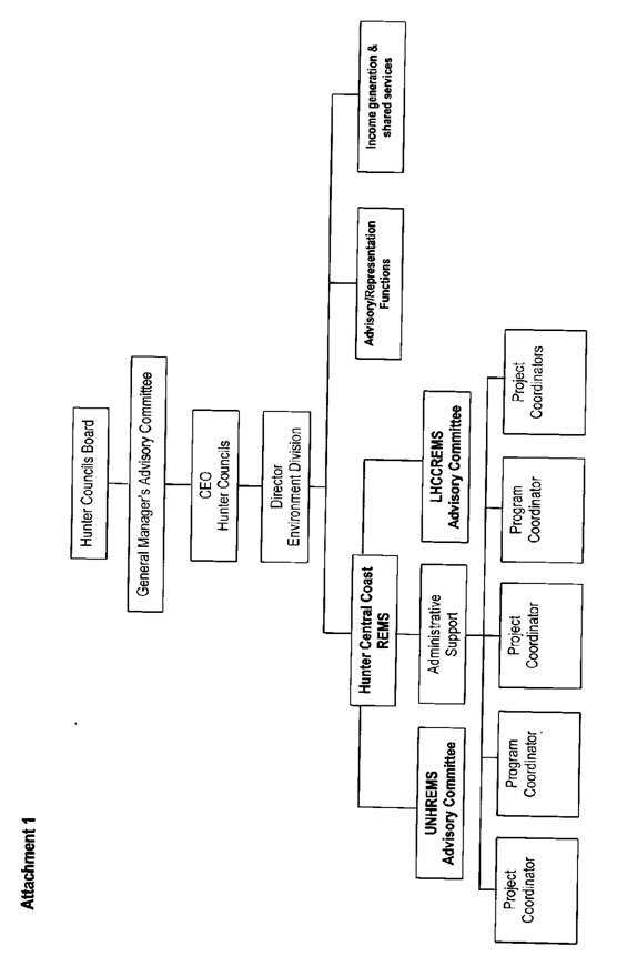
represented. One Committee that was
not considered was the Upper – Northern Hunter Regional Environmental
Management Strategy.
Councillors
may recall that this was intentionally deferred at the time as the Board of
Hunter Councils Inc. was undertaking a process of rationalising the
operations of this Committee and the equivalent body within the Lower
Hunter. This process has now been
concluded and a copy of an item of correspondence from Hunter Councils Inc.
is attached to this report for Councillors perusal.
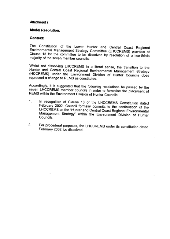
Part 1 of the
letter deals with matters impacting on the Lower Hunter and Central Coast
REMS Steering Committee which has no impact on Singleton Council.
Part 2 of the
letter deals with the appointment of the members to the Hunter Central Coast
REMS Steering Committees and in this regard the correspondence suggests that
Member Councils each nominate two representatives (one Councillor and one
professional officer) to the relevant Steering Committee to provide strategic
guidance to HCC REMS Projects and Programs.
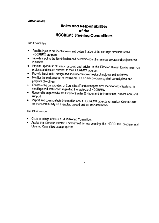
One of the
attachments to the correspondence from Hunter Councils Inc. makes reference
to the roles and responsibilities of the HCC REMS Steering Committees.
Council’s
Manager Planning & Development Services is the Council officer who has
been authorised to attend the Upper Northern Hunter REMS Steering Committee.
It is now
necessary for Council to appoint a Councillor representative to the Upper
Northern Hunter REMS Steering Committee.
|
|
RECOMMENDED that
Council nominate a Councillor for appointment to the Upper – Northern Hunter
REMS Steering Committee.
|
Attachments
|
AT-1
View
|
Upper - Northern Hunter REMS
|
3 page(s)
|
Steve McGrath
General Manager
|
Attachment 1
|
General Manager's Report No. 14/04
|
|
Upper - Northern Hunter REMS
|
Upper - Northern Hunter Regional Environmental
Management Strategy
|
|
|
|
|
SINGLETON
COUNCIL
|
Meeting of the Corporate
and Development Services Committee - 13 September 2004
|
|
|
|
|
|
Economic
Development Officer’s Report No. 6/04
|
|
|
|
|
1. Minutes_Item
|
Economic
Development
Author: Don
Gray
|
FILE: 02/0028
|
|
During the months of July and August 2004
Councils Economic Development Officer
(EDO) dealt with the following items:
|
1.1 Inquiries
Property Inquiries (Apart from Country Week)
· Industrial 11
· Commercial 5
· Residential 3
General Inquiries
· Familiarisation tours 1
· Statistical Inquiries 9
1.2 Meetings
Coal Awareness Days
The traditional Coal Discussion Day
will this year be replaced by a two day event to be
known as Coal
Awareness Days.
On
the afternoon of Friday 29 October proceedings will be opened by the Minister
for Minerals and Energy the Hon. Kerry
Hickey MP. This session will consist of two speakers and a forum to discuss the sustainability of the mining
industry.
On
Saturday 30 October mine site tours will be conducted for the public.
Towns and Villages Futures Program (TVFP)
On Wednesday 21 July 2004 a second community meeting of the
TVFP was held at Bulga and was well
supported. Further workshopping was undertaken and subsequently a Strategic
Plan
for the local communities was produced.
Five
key initiatives (in order of priority) that were identified were:
· Brand for the whole
region
· Visitor Information
Centre
· Combined newsletter
· Improved access to national parks
· Arrest or reverse Wollombi Brook
degradation
As a result of
these findings an application for a second round of funding for “Branding and Marketing” the region has been submitted
under the same program. This application had to be submitted by 01
September 2004 to avoid a 12 month delay.
Singleton Development Support Team (SDST)
The SDST
has undertaken as survey of 420 businesses to establish the skills shortage and
training needs of businesses in the
LGA.
120
responses have been received and a further report will be issued on the
results.
Country Week
Councils EDO attended Country Week in at Homebush Stadium in Sydney for 13 – 15 August 2004. Singleton, along with around 30
other Councils had a stand aimed at attracting persons
to Singleton particularly those with trade skills. Two local businesses,
Ellavale and Jim Gaulds Building assisted with the manning the
displays.
Interest
in move out of Sydney
to rural NSW was high and to date one business and one family have indicated their intention to relocate.
2.0 Statistical Data
A review
of development applications received by Councils for the first six months of
2004 is shown below:
January to March 2004 (Value in $1000 of
applications)
Residential $15132
Industrial $ 733
Commercial $476
Infrastructure $942
Tourism $1502
Mining/Power $132
Housing
applications 67
April to June 2004
Residential $13832
Industrial $315
Commercial $1740
Infrastructure $10626
Tourism $104
Housing
applications 64
|
FOR COUNCIL’S
INFORMATION
|
Attachments
There are no attachments for this report.
Don
Gray K
S McMurray
Economic
Development Officer Director
Corporate & Development Services
|
1.
|
2003/2004
Annual Financial Reports
Author: Anthony
Egan
|
FILE:
|
|
Executive
Summary
To present details of the Draft Annual Reports to Council for
adoption and referral for audit.
|
Background:
Annually Council is required to refer the Annual Financial Reports
for audit.
Management Plan:
The 2003/2004 Annual Financial Reports represents Council Financial
performance for the 2003/2004 Financial Year which formed part of Council’s
adopted 2003/2004 Management Plan.
Council Policy: N/A
Legislation:
Section 413, 415 and 416 of the Local Government Act 1993 requires
that the Council’s General Purpose and Special Purpose Annual Financial Reports
for 2003/2004 to be prepared, referred to audit and audited by 31 October, 2004.
In regards to this process, Council is required to authorise the
referral of the Financial Reports to Council’s Auditor. In addition, Section
413 (2)(c), requires that Council provide a statement as to its opinion on the
annual financial statements of account. This statement must be made by
resolution of the Council and signed by the Mayor, at least one other
Councillor, the General Manager and the Responsible Accounting Officer (Manager
Finance), in accordance with the Local Government (Financial Management)
Regulations 1999.
Sustainability:
Social:
N/A
Environmental: N/A
Financial: The financial
result for 2003/2004 is shown on the Statement of Financial Performance which
indicates a surplus from all activities of $14,524,000. Incorporated in this
result is the identification of $2,983,000 from developers being the valuation
of infrastructure assets that have been dedicated to Council during the
2003/2004 financial year.
The
result before capital amounts shows a surplus of $7,930,000 which includes a
depreciation expense of $6,585,000.
The 2003/2004 Financial Reports disclose a land development profit
of $8,405,000 following the sale of 97 lots. This result represents an increase
of $6,621,000 from the previous financial year.
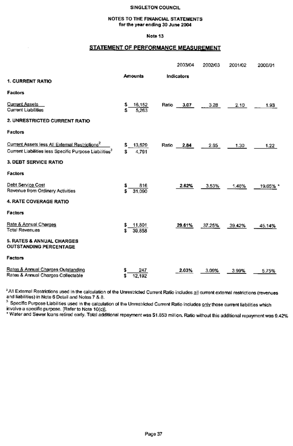
Note 13 to the Financial Statements details Council's key financial
indicators. The Current Ratio indicates the adequacy of working capital and the
ability to satisfy obligations in the short term for the consolidated entity.
The consolidated Current Ratio stands at 3.07 as at 30 June 2004.
The Unrestricted Current Ratio assesses the adequacy of working
capital and the ability to satisfy obligations in the short term for the
unrestricted activities of Council. This ratio has decreased to 2.84 as at 30 June 2004.
Council will be more aware of the Debt Service Ratio which assesses
the degree to which revenues are committed to the repayment of debt. This ratio
for the consolidated entity stands at 2.62%.
The Rate Coverage Ratio indicates the proportion of rate income to
total income received for the financial year.
This indicator provides a good representation of Council's reliance on
rate income to offset expenditure. As at 30 June 2003 this ratio stood at 29.61%, which
is down on the prior year due to increases in proceeds from land sale and
developer provided assets.
The Rates and Charges
Outstanding percentage has decreased to 2.03%. This represents an improvement
of 34% on the previous years result.
The financial indicators referred to in this report have been
incorporated in Attachment A for quick reference.
Consultation: N/A
Risk Management: N/A
Options:
Council is required by legislation to refer the Annual Financial
Reports for Audit. Accordingly there is no other option than to adopt the
recommendation.
Conclusions:
A further report will be presented to Council’s Ordinary Meeting to
be held on 23 September 2004
in relation to the actual cash position of Council performance for the
2003/2004 financial year.
|
RECOMMENDED
That in accordance with the provisions of Section 413 (2)(c) of
the Local Government Act 1993 (as amended) and the Financial Management
Regulations, in Council's opinion:
a) the Council's
Annual Financial Report has been prepared in accordance with;
(i) the Local Government
Act 1993 (as amended) and Regulations,
and
(ii) the Statement of
Accounting Concepts, and
(iii) the Local
Government Code of Accounting Practice and Financial Reporting, and
(iv) the Local
Government Asset Accounting Manual,
and
(v) the Australian
Accounting Standards.
the reports
present fairly the Council's financial position and operating result for the
year, and
the reports
accord with the Council's accounting and other records, and
we are not aware
of anything that would make the reports false or misleading in any way.
b) That
the Special Purpose Financial Reports have been drawn up in accordance with
the Local Government Code of Accounting Practice and Financial Reporting.
c) That
the General and Special Purpose Financial Reports be certified by the Mayor,
Deputy Mayor, General Manager and Responsible Accounting Officer (Manager
Finance).
d) That
Council approves the Annual Financial Statements of Accounts (including
General Purpose and Special Purpose Reports) for the year ending 30 June, 2004 being
referred for audit.
|
Attachments
|
AT-1
View
|
Statement of Performance Measure
|
1 page(s)
|
K S McMurray
Director
Corporate & Development Services
|
Attachment 1
|
Director Corporate and Development Services Report
No. 23/04
|
|
Statement of Performance Measure
|
2003/2004 Annual Financial Reports
|
|
|
|
|
SINGLETON
COUNCIL Minutes_Item
|
Meeting of the Corporate
and Development Services Committee - 13 September 2004
|
|
|
|
|
|
Manager
Planning & Development Report No. 10/04
|
|
|
|
|
1.
|
ROAD NAMING
OF SUBDIVISION ROAD
Author: Mark
Ihlein
|
FILE: SA 29/1994
|
|
Applicant: Mrs M J Tolmie
Owner: Mrs M J Tolmie
Land and Location: Lot 1 DP 867984, 271
Retreat Road, Wattle Ponds
Zoning: Rural 1(d)
Small Holdings
Proposal: Road Naming
Date of Application: 16 July, 2004
Responsible Officer: Craig Maher
Executive
Summary
N/A
|
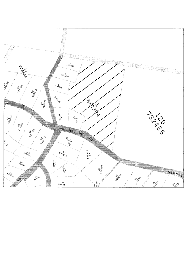
Proposal
Council is currently in receipt of an
application for the naming of a new subdivision road off Retreat Road, Wattle Ponds.
The applicant has submitted three names to
be considered, and advised that the preferred name for the road is “Wilhannah
Close”.
Wilhannah recognizes the applicant’s first
Australian Ancestors, William and Hannah Singleton. The chosen name is not included on Council’s
list of possible road names however, given the historical significance the name
is considered to have merit.
The road name selected is not currently in
use within the Shire, and is therefore recommended for adoption as the road
name for this new subdivision road.
History
Council approved a staged eleven (11) lot
subdivision for Mr A & Mrs M J Tolmie on 10 July, 1996.
A locality plan is appended to this report as Attachment “1” and a plan of the proposed subdivision is appended
as Attachment “2”.
Site Characteristics
The proposed access road is currently being
constructed directly off Retreat
Road and will be completed in the near future.
Statutory Considerations
N/A
Sustainability:
Social N/A
Environmental NA
Financial NA
Conclusions
The chosen road name is acceptable and
should be adopted
|
RECOMMENDED
That Council pursuant to Section 162 of
the Roads Act, 1993 and the Roads (General) Regulation, 2000, adopt the name
Wilhannah Close as the name of the new subdivision road off Retreat Road,
Wattle Ponds.
|
Attachments
|
AT-1
View
|
Locality Plan
|
1 page(s)
|
|
AT-2
View
|
Subdivision Plan
|
1 page(s)
|
|
Attachment 1
|
Manager Planning & Development Report No. 11/04
|
|
Locality Plan
|
ROAD NAMING OF SUBDIVISION ROAD
|
|
|
|
|
Attachment 2
|
Manager Planning & Development Report No. 11/04
|
|
Subdivision Plan
|
ROAD NAMING OF SUBDIVISION ROAD
|
|
|
|
|
SINGLETON COUNCIL Minutes_Item
|
Meeting of the Corporate
and Development Services Committee - 13 September 2004
|
|
|
|
|
|
Manager
Planning & Development Report No. 10/04
|
|
|
|
|
2.
|
NEWCASTLE SPORTS PARACHUTE CLUB COMMUNITY CONSULTATIVE COMMITTEE (NSPC-CCC)
Author: Mark
Ihlein
|
FILE: 00/0190
|
|
Executive Summary
Council has requested the NSPC-CCC to
determine whether or not the Committee should be dissolved.
|
A meeting of the NSPC-CCC was held on 27th February 2004, which amongst
other matters, considered an item in respect of the continuance of the
committee. A copy of the Draft Minutes
are attached.
Consideration of the item resulted from a request of Council to ask the
committee to determine whether it should be dissolved.
The general consensus of the meeting was to disband the consultative
committee. However, it was agreed that
the absent member of the committee should be consulted, Mr Steve Thornton, and
his views sought. A copy of the
correspondence forwarded to Mr Thornton is attached.
As no written response was received the Manager Planning and Development
Services spoke with Mr Thornton via telephone who advised he had no objection
provided there was implementation of an appropriate process to deal with
complaints and the committee can be reactivated at the request of either the
NSPC or community representation.
Council has an existing complaints management system where customer
action requests are logged and forwarded to an appropriate officer for
investigation. Alternatively complaints may be made in writing to the General
Manager which are forwarded to an officer for action.
|
RECOMMENDED
1. That
the Newcastle Sports Parachute Club Community Consultative Committee be
dissolved.
2. The Committee be
reactivated at the request of either the Newcastle Sports Parachute Club or
community representation.
|
Attachments
|
AT-1
View
|
Draft Minutes - Newcastle Parachute Club Community
Consultative Committee
|
1 page(s)
|
|
AT-2
View
|
Letter to S Thornton
- Newcastle
Parachute Club Community Consultative Committee
|
1 page(s)
|
|
Attachment 1
|
Manager Planning & Development Report No. 11/04
|
|
Draft Minutes - Newcastle Parachute Club Community
Consultative Committee
|
NEWCASTLE SPORTS PARACHUTE CLUB
COMMUNITY CONSULTATIVE COMMITTEE (NSPC-CCC)
|
|
|
|
|
|
|
DRAFT
MINUTES OF THE NSPC COMMUNITY
CONSULTATIVE COMMITTEE MEETING HELD
ON FRIDAY 27 FEBRUARY 2004, AT SINGLETON
COUNCIL’S ADMINISTRATIVE BUILDING
ATTENDANCE Mayor Cr F
Harvison, P Maguire, M Roser, M Ihlein, 2 club reps
APOLOGISE S
Thornton
OPENING Mayor
Harvison – Chairman of the NSPC CCC opened the
ADDRESS meeting
at 9:00am.
BUSINESS ARISING
§ Chairmans function 2003
and Function 2004
§ Details on effluent
system approved clarification as to what was submitted.
§ Discussion on noise
testing of air craft. Air services Aust
comment on testing. Air Services letter to PM.
§ Suggestion to include
additional data in any noise test results.
§ Committee reps policy
requires min 2 and max 4 for club and community.
§ Issue raised about
community reps living within the area.
§ No additional matters
to do with the club.
§ Paul asked for an
explanation on function weekends which was provided.
§ Fred discussed previous
report and subsequent Council resolution on dissolving of the CCC.
§ Decision not to
undertake vote to dissolve CCC as ST was not aware of this and it would be
unfair to conduct a vote without knowledge of all members of this
occurring. The general consensus was
however to disband the CCC subject to advice from Steve Thornton.
§ Flights per operating
day.
§ Operating weekends per
month.
§ Noise from functions.
§ PM concerns regarding
the ability to monitor plane noise.
§ To include Council
report and resolution to all committee members.
§ ST through MR to remind
the club on no-flying weekend.
§ MI asked the committee
to thank MR on his involvement in the CCC.
Closed Meeting – Mayor 10.15am
Enquiries to: M
Ihlein
02 6578 7330
Our
Ref: PN 00190
01 March 2004
Mr Steve
Thornton
73 Bulwer Street
MAITLAND NSW
2320
NEWCASTLE SPORTS PARACHUTE CLUB
COMMUNITY CONSULTATIVE COMMITTEE (NSPC CCC)
It is advised a
meeting of the NSPC CCC was held on 27 February 2004 and considered an agenda item in respect
of the future continuance of the committee.
This item is at the request of the Council which resolved to ask the
committee to determine whether it should be disbanded. A copy of the report to Council and the
resolution is enclosed for your information.
The general
consensus of the meeting was to disband the NSPC CCC, however it was agreed
that prior to any formal resolution in this regard, you should be consulted as
one of the community representatives and your views sought.
Should the CCC
be disbanded, the meeting agreed that it would be subject to implementation of
an appropriate process to deal with complaints and the committee can be
reactivated at the request of either the NSPC or community representation.
It would be
appreciated if you could provide your comments directly to the undersigned
either in writing or verbally by Friday, 12 March 2004.
Please do not
hesitate to contact the undersigned should you require further clarification or
wish to otherwise discuss the matter.
Mark Ihlein
Manager – Planning & Development Services
MI.jjg
CC Clr
Harvison, Mayor – Singleton Council, PO
Box 314, Singleton
Mr
Paul Maguire, 664 Elderslie Road,
Elderslie, 2330
NSPC,
PO Box 116,
Branxton 2335
|
SINGLETON COUNCIL Minutes_Item
|
Meeting of the Corporate
and Development Services Committee - 13 September 2004
|
|
|
|
|
|
Manager
Planning & Development Report No. 10/04
|
|
|
|
|
3.
|
RURAL
RESIDENTIAL DEVELOPMENT STRATEGY - STEERING COMMITTEE
Author: Mark
Ihlein
|
FILE: 01/0059
|
Council will be aware that the Rural Residential Development Strategy
has been under preparation for some considerable time. Most of the delays in the process are a
result of addressing issues raised by the National Parks and Wildlife Service
in respect of biodiversity and Aboriginal archaeological issues.
Council officers have now received the Strategy report from the
consultants which is currently being reviewed.
It is envisaged that during October the steering committee will need to
be briefed and a detailed report subsequently presented to Council with a view
to public exhibition.
The Councillor representation on the steering committee was former
Councillor Golenia, and Councillor Urpeth, and Councillor McNamara. It is now timely for Council to re-elect
representatives to the committee. Given that the strategy will apply to the
rural areas it is suggested that the four rural Councillors be elected.
The other members of the original steering committee were; Garry Hamblin
– Surveyor, Murray Shaddock – Real Estate, Barry Russell – Landcare
Co-ordinator, Kay Stacy – NSW Farmers Council, Keith Lobb – Rural Fire Service,
Jo-Anne Adam – Rural Resident and Sue Moore – Resident.
It is proposed to write to each of the members to gauge their interest
in participating in a briefing session during October.
|
RECOMMENDED
That the four
rural Councillors be elected as Councils representatives for the Rural
Residential Development Strategy Steering Committee.
|
Attachments
There are no attachments for this report.
|
SINGLETON COUNCIL Minutes_Item
|
Meeting of the Corporate
and Development Services Committee - 13 September 2004
|
|
|
|
|
|
Manager
Planning & Development Report No. 10/04
|
|
|
|
|
4.
|
QUESTIONS
WITHOUT NOTICE
Author: Mark
Ihlein
|
FILE: 01/0450
|
Q143/04 - Clr MacBain
Seeking clarification as to the difference between subdivisions
resulting from Parish Portions compared with Torrens Title.
To fully answer this question the issue of dwelling entitlement and
subdivision need to be addressed in respect of Parish Portions and Torrens
Title lots.
Parish Portions
This is a form of “old system” title which can be transferred to
different owners without the need for any Council approval. Within the 1 Rural
Zone a dwelling can only be erected on land greater than 40 hectares or on an
allotment of land with an area of less than 40 hectares where the land is an
allotment created prior to 7th January, 1966 and comprises the whole
of an existing holding.
There is a 40 hectare minimum subdivision provision and some limited
concessional lot entitlements, where an existing holding has an area of not
less than 10 hectares.
Torrens Title Lots
These are also sometime referred to as new systems title and are
represented as a lot and DP. The
dwelling entitlement and subdivision provisions are the same as for Parish
Portions.
Attachments
There are no attachments for this report.
|
SINGLETON COUNCIL Minutes_Item
|
Meeting of the Corporate
and Development Services Committee - 13 September 2004
|
|
|
|
|
|
Manager
Planning & Development Report No. 10/04
|
|
|
|
|
5.
|
Subdivision -
14 Allotments
Author: Erica
Duffy
|
FILE: SA 39/2004 (DA 381/2004)
|
|
Applicant: Jall Projects
Owner: Stannic Securities Pty Ltd
Land and Location: Lot 12 DP 219780
Zoning: Rural 1(a)
Proposal: To subdivide the land into fourteen (14) allotments
Date of Application: 8 June 2004
Responsible Officer: Erica Duffy
Executive Summary
The applicant is requesting Council
approval to subdivide a 528Ha lot into 13 x 40Ha allotments and a 1 x 4.5ha
concessional allotment. The subject land has been used as a grazing and beef
cattle stud. The application includes the construction of a new road
providing access to 10 of the proposed allotments as well as an upgrading of Cranky Corner Road
where it fronts the proposed lots. Furthermore, Council policy requires a
proportional contribution to the upgrading of Cranky Corner Road between the subject
land and the intersection with Stanhope
Road, including a timber bridge crossing
Stanhope Creek. The proportion of upgrading required is the proportion of
additional lots created by this proposal in relation to the total number of
lots with access via Cranky
Corner Road.
The application is forwarded to Council
for determination as there were objections to the proposal. The objections
raised related to the condition of Cranky
Corner Road, the subdivision of a large holding,
possible adverse impacts on the natural environment and the provision of a
farm-gate garbage service. These issues and other issues pertaining to the
proposal are discussed in detail in the report.
The report concludes with the
recommendation that the application be approved subject to the conditions
listed which will mitigate possible adverse impacts from proposal. The
approval is recommended as a deferred commencement pending the submission of
a flood study which will provide Council with the extent of works necessary
to ensure the existing timber bridge on Cranky Corner Road is of suitable
construction and height to comply with Council requirements for the total
number of vehicles using this road.
|
Proposal
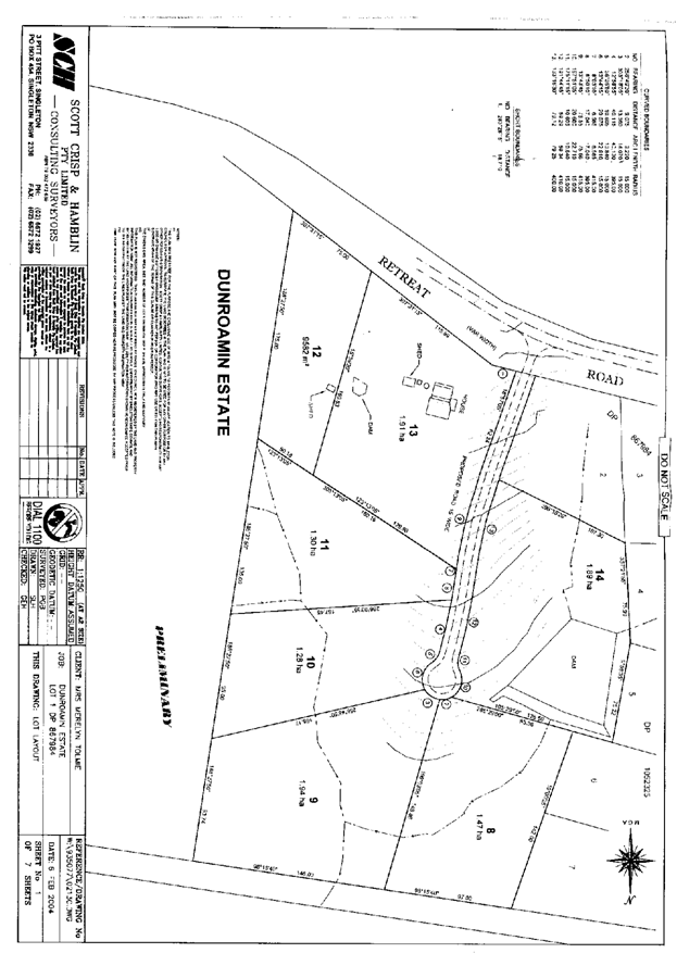
This application is for the subdivision of
a 528Ha allotment into 13 x 40Ha allotments and a 1 x 4.5Ha concessional
allotment.
History
The subject land was created by a
subdivision approved by Council in 1963. The land has owned by the same family
for the last 40 years and run in conjunction with other adjoining land as a
grazing and beef cattle stud.
Site
Characteristics
The subject land is located on either side
of Cranky Corner Road
approximately 2kms from Stanhope
Road. A Locality Map is appended to the report as Attachment “1”. The land to the east of
Cranky Corner Road
is characterized by a central ridgeline which trends in an east-west direction.
This area is characterized by a number of intermittent streams which flow from
the central ridge to Stanhope Creek which is along the property’s north
boundary. Stanhope Creek then meanders through the property and exits at the
south western. With the exception of a vegetated hill in the south-eastern
corner, the eastern portion of the subject land has been extensively cleared of
native vegetation reflecting its past and current use of livestock grazing. Land
to the west of Stanhope Road
is generally lower lying and includes the valley containing Stanhope Creek.
A copy of the proposed subdivision,
overlayed on a topographic map, is appended to the report as Attachment “2”.
Statutory
Considerations
(a) the
provision of:
(i) Any
environmental planning instrument.
EP&A Act
Under s91(1) of
the Environmental Planning and Assessment Act 1979, the proposal is Integrated
Development requiring response from the NSW Rural Fire Service(RFS). The
response from the RFS included one General Terms of Approval which has been
included in the conditions.
Hunter Regional Environmental Plan
Under the
provisions of Cl.27 of the Hunter Regional Environmental Plan 1989 (HREP), the
concurrence of the Director-General of the Department of Agriculture is
required prior to subdivision of prime crop and pasture land (Class 1, 2 or 3).
Council’s maps show part of the subject land is Class 3 and part is Class 4.
Council’s agriculture map does not show all the subject land, however it
appears that the prime pasture land (Class 3p land) includes the land adjacent
to Stanhope Creek which runs through the subject land. Class 3 is defined as “Land not suitable to
regular cultivation. Includes some arable and some pasture lands with moderate
levels of agricultural production. Well suited to pasture improvement and can
be cultivated for an occasional crop”. The suffix “p” is for pastures.
It appears from
Council’s maps that the ridge which runs approximately east-west on the subject
land is classified as Class 4 land. Class 4 is defined as “Land not suited for
cultivation. Poor grazing or lands with seasonal grazing capabilities. Overall
level of production is low.”
The concurrence
of the NSW Department of Primary Industries (DPI) was sought for the proposal
and their response is appended to the report as Attachment “3”.
The applicants
response to the DPI submission has been appended to this report as Attachment “4”. Council officers
conclude that while it may be regrettable that large, previously economically
viable agricultural holdings are subdivided, this is a reflection of the
economic value of land generally and is not isolated to this area, Singleton
LGA or the Hunter Region.
Under the
provisions of Singleton Local Environmental Plan 1996, the 1(a) Rural zone objectives are:
(a) to protect and conserve agricultural land and to encourage
continuing viable and sustainable agricultural land use;
(b) to promote the protection and preservation
of natural ecological systems and processes;
(c) to maintain the scenic amenity and landscape
quality of the area;
(d) to provide for the proper and co-ordinated
use of rivers and water catchments;
(e) to promote provision of roads that are
compatible with the nature and intensity of development and the character of
the area.
On balance it is
considered that the proposal is consistent with the zone objective contained
within the SLEP.
Singleton Local Environmental Plan
Under the
provisions of Cl. 7(1)(a) of the Singleton Local Environmental Plan 1996
(SLEP), the minimum lot size for land zoned Rural 1(a) and with dwelling
entitlement is 40 Ha. Under the provisions of Cl. 17(1)(c) and through a search
of Council records one concessional allotment is permissible.
The proposal to
create 13 x 40ha lots and 1 x 4.5ha lots is permissible.
(ii) Any draft
environmental planning instrument that is or has been placed on public
exhibition and details of which have been notified to the consent authority.
No such document
applies to the proposal or land.
(iii) Any
development control plan.
No development control
plan applies to the proposal.
(iv) Any
matters prescribed by the regulations, that apply to the land to which the
development application relates.
No such matters
apply to this land.
(b) The likely impact of that development, including environmental
impacts on both the natural and built environments, and social and economic
impacts in the locality.
Context & Setting
Land to the
north of the subject land is a grazing property which contains a dwelling. Land
further north, off Bimbadeen Road
has been recently subdivided and sold as 40Ha allotments. Land to the east and
the west is predominantly used for grazing with a variety of holding sizes.
Land to the south is predominantly used for grazing of livestock. The locality
of Stanhope is located approximately 1km south of the subject land on Stanhope Road.
Properties on either side of Stanhope
Road are used for livestock grazing, lucerne
production and cultivation of occasional vegetable crops.
The dominant
feature of the landscape is the steep and vegetated ridges north of the subject
land which contrasts with the cleared, undulating and rolling hills of the
subject land and surrounding lands. The area is characterised by scattered
dwellings associated with rural grazing
properties.
It is considered
that the proposed development is not inconsistent with the surrounding land
uses.
Access & Transport
The primary
means of access to the proposed subdivision is via a new subdivision road which
follows the main ridgeline that runs in an easterly direction through the site.
The proposed road is approximately 2.2 kilometres long with a cul de sac at its
extremity. This road intersects with Cranky
Corner Road (South) approximately 2.9 kilometres
from Stanhope Road.
Cranky Corner Road
at this location is currently of unsealed gravel formation in reasonable
condition. Ten (10) of the proposed allotments are served directly by the new
subdivision road and the remaining four (4) are accessed directly via Cranky Corner Road.
The proposal
will result in an additional 126 vehicles per day (VPD) utilising Cranky Corner
and Stanhope Roads. Stanhope Road is sealed, in good condition and considered
of sufficient width to handle the additional traffic loading generated by this
subdivision. As mentioned above Cranky
Corner Road is currently unsealed and will
therefore require upgrading to handle the additional traffic loading generated
by this subdivision.
The applicant has undertaken an analysis of the lots currently
served by Cranky Corner Road,
and has determined that 48 lots currently utilise Cranky Corner Road.
Therefore, the additional 14 lots created by this subdivision
represent a net increase in vehicle movements on Cranky Corner Road of approximately
22.5%. This figure will be utilised to determine the required upgrading of the
existing timber bridge on Cranky
Corner Road and the required upgrading of Cranky Corner Road
towards Stanhope Road. The works department has advised the cost to
upgrade the timber bridge is $120,000.00.
Therefore, based on the 22.5% increase in vehicle movements, the
calculated contribution towards the bridge upgrade is $27,000.00. In respect of the required road upgrade, the
applicant will be required to upgrade 22.5% of the 2.1 kilometres of Cranky Corner Road
from the development site to Stanhope
Road, a distance of 470 metres. Both the contribution and road upgrade will
be reflected as conditions of consent.
Road Standards:
New Subdivision Road
· Cranky Corner Road to the eastern boundary of proposed Lot
3 – 7 metre seal on 8 metre formation.
· From the eastern
boundary of proposed Lot 3 onwards – 4 metre
seal on 6 metre formation with passing bays every 200 metres and a 12.5 metre
radius cul de sac bulb.
Cranky Corner
Road
· From the western
boundary of the subject land to the intersection of the proposed subdivision
road – 7 metre seal on 8 metre
formation.
· From the
intersection of the proposed road to midway along the boundary of proposed Lot 1 – 4 metre
seal on 6 metre formation.
All of the above road requirements will be reflected
as conditions of consent.
Utilities
Overhead power is
currently available to the subject land. Council will require the applicant to
provide documentary evidence from the electricity supplier that provisions have
been made for power supply to each proposed allotment. A condition has been
included requiring this.
A Council
approved On Site Sewerage Management Systems (OSSMS) will be required for
dwellings on each of the proposed lots. The applicant advises that consultant
geotechnical engineers and scientists concluded that effluent from future
residents of the subdivision could be safely disposed of within the potential
building envelopes for each of the proposed vacant allotments. Various methods
for on-site treatment will be able to be utilised given the size of the
allotments, soil types and distances to streams and watercourses.
Potable water
will be obtained by the collection and storage of roof water in appropriately
sized tanks. A postal service, school bus and a garbage collection service is
available at the intersection of Cranky
Corner Road and Stanhope Road.
Heritage
An archaeological
assessment was undertaken with local aboriginal community organisations
including Mindaribba Local Aboriginal Land Council, Lower
Wanaruah Tribal Consultancy Pty Ltd, the Combined Council Hunter
Valley Aboriginal Corporation, Wanaruah Custodians, Lower Wanaruah Tribal
Council Inc and the Ungooroo Aboriginal Corporation. The major findings of the
assessment were that there are several sites considered to be of medium – high
archaeological significance due to their nature, content and location.
The report
concluded with the following recommendations:
· The study area is considered to have Aboriginal heritage potential.
· The above conclusion is reached based on
Aboriginal consultation and advice, background archaeological/historical
research, field assessment and land-use history.
· Several Aboriginal sites recorded (ie Stanhope
Creek 9,15 & 17) are considered to be of medium-high archaeological
significance due to their undisturbed nature, contents and location. Buffer
zones will be required to be placed around these sites to prevent further
disturbance. Attachment “5” notes
the location of these sites.
· The remaining seven sites and nine
isolated finds are considered to be of low archaeological significance, due to
their physical condition and the potential for insitu cultural material to be
found in association with them.
· In order for the sub-division proposal to
proceed without delay; sites and artefacts that have been recorded would need
to be conserved. As most of the building and construction is associated with
flat dry ground, it is unlikely that any of the artefacts recorded will be
disturbed as a result of development impacts.
· If the development impacts were likely to
affect existing Aboriginal Sites and Objects, the sub-division proposal would
be required to seek Section 90 Consent Approval under the NSW National Parks
& Wildlife Service Act 1974. This would require additional archaeological
assessment work and may delay project construction for up to 8 weeks.
· If as a result of any future development
on the land, Aboriginal objects or sites are located, the developer is required
by law to stop all work and immediately inform the NSW National Parks &
Wildlife Service.
Conditions have
been included that reflect the above recommendations.
Council received
a letter from Noel Downs from the Wanaruah Local Aboriginal Land Council
requesting that they be involved in a survey of the subject land. On the 13th July 2004,
Council advised the Wanaruah Local Aboriginal Land Council that an Aboriginal
Cultural Heritage Survey had already been undertaken on the subject land in the
preparation of the Statement of Environmental Effects. No further
correspondence has been received from the Wanaruah Local Aboriginal Land
Council.
Water
The subject land
is not prone to inundation by waters associated with a 1:100 year flood event
of the Hunter River. Localised flooding associated
with Stanhope and Pine Creeks are generally contained within stream banks. Any
flooding would be of short duration, typical of first and second order
watercourses on the upper end of catchments. Each of the proposed allotments
contains a potential dwelling envelope which is elevated and flood free.
Flora & fauna
A flora and fauna
assessment of the land was undertaken and included in the Statement of
Environmental Effects. The flora and fauna assessment concluded that one
threatened species (Grey-crowned Babbler), no endangered populations, and/or
endangered ecological communities of State or national environmental
significance were observed within the site during the survey period. There is
anecdotal evidence, from the previous landowner indicating the presence of two
threatened species, namely the Spotted-tailed Quoll and the Brush-tailed
phascogale. The clearing of native vegetation will be minimal as a result of
the proposal and there is unlikely to be any significant impact on local and/or
regional wildlife corridors.
The assessment
concludes that there is unlikely to significant impact on matters of State or
National Environmental Significance provided the following recommendations are
undertaken:
· Retain mature trees where possible;
· Restrict tree felling to periods of low fauna breeding activity such
as autumn;
· Assess the occupancy of tree hollows prior
to the initiation of land clearing activities;
· Replace tree hollows lost to the redevelopment
of the site by erecting appropriately dimensioned nest boxes in suitable
locations at a ratio of 2:1 or greater;
· Install road signs on Cranky Corner Road, near the western
boundary of the site, to raise driver awareness to threatened species activity
within the road corridor. The road signs should indicate the type of species or
fauna in the area; and
· Discourage the collection of fallen timber
and cutting down of trees (including dead trees) by future residents through
appropriate signage at environmentally sensitive locations.
The
recommendations of the report are reflected in the recommended conditions of
approval.
Natural hazards
Both the subject
property and Cranky Corner Road
are affected by Stanhope Creek. A timber bridge on Cranky Corner Road currently spans
Stanhope Creek.
It is understood
that the existing bridge may be inundated in the larger flood events ie: 100
and 50 year ARI and thus isolating the newly created lots for a short period of
time. The applicant will therefore be required to carry out a flooding /
drainage study to determine the exact level and duration of inundation of the
existing bridge. The study will ensure the bridge is not adversely affected by
the calculated flood flows, and will aid in determining the final mode of
upgrade to be carried out. The study has
not been provided to date and will therefore be conditioned as a deferred
commencement condition.
The subject land
has a few areas that are within a bushfire prone area. The areas correspond to
isolated areas of existing vegetation generally along the south and east
boundaries of the land. The proposal is integrated development and was referred
to the Rural Fire Service (RFS) for concurrence. The RFS have provided the
General Terms of Approval and these are included in the conditions.
Socio-economic impact in the locality
The applicant
advises that the subject land has been farmed by the one family for 40 years
and the previous owner has relocated the business to a larger property with the
intention of expanding the breeding stock and drought proofing the farm,
thereby continuing and developing a sound farming business with benefits to the
wider economy. Property values in the Hunter Valley
have increased and this makes it difficult to sustain a business of this type
and size in this locality.
A school bus
service, postal deliveries and garbage service are available at the junction of
Stanhope Road
and Cranky Corner Road.
Stanhope locality includes a community tennis court and Rural Fire Brigade
which provides a focus for the residents of the area. Retail and commercial
services are available within 30 mins drive of the property at Singleton,
Branxton and Maitland.
The proposed
subdivision will create one small rural retreat and 13 small farming sites
which have the potential to increase rural productivity and provide direct and
indirect employment and population growth in the Stanhope, Branxton and
Singleton communities.
There have been
several similar type developments undertaken in recent years in Lambs Valley
and Bimbadeen Road.
It is understood that most of this land has been sold and there continues to be
a market for land. The local building industry and associated trades will
benefit from subdivision work and subsequent housing and development.
New and existing
residents will benefit from the establishment and embellishment of community
based facilities due to the proponent contribution to Council’s s94
Contributions Plan.
Site design
The layout of the
proposed subdivision includes a new road which runs along the central ridge
with 10 proposed allotments having access to this road and four allotments with
access onto Cranky Corner Road.
Each of the proposed allotments have nominated at least one dwelling site,
these are considered to generally comply with Council requirements which
includes minimum boundary setbacks, flood free sites with suitable asset
protection distances for bushfire protection. The design of the proposal is
considered to comply with Council requirements with respect of layout. Suitable
access crossings will be required to each of the proposed lots.
Cumulative impact
The proposal is
similar to previously approved subdivisions in Lambs Valley
and Bimbadeen Road.
These approvals have resulted in change in the physical, social, cultural and
economic character of the area. As previously discussed in the report, there is
a continued demand for this type of development in this general locality. On
balance the proposal is unlikely to have any significant increased adverse
impact in the locality.
Any negative
cumulative impact on the existing road network has been addressed by either
road upgrading or the payment of contributions to cover the cost of upgrading
the existing infrastructure on a “pro rata” basis.
(c) The
suitability of the site for development
.
The proposal is
considered to fit in the locality and the site attributes are considered to be
conducive to the development.
(d) Any
submissions made in accordance with this Act or the regulations.
The proposal was
notified for ten days and four submissions were received. The submissions are
summarised below and copies are appended to the report as Attachment “S1” to “S4”.
(S1) Maureen
& George Dick – object to the proposal due to
increased noise and dust levels from the additional traffic using Cranky Corner Road,
run-off will destroy Stanhope Creek and increased numbers of domestic dogs and
cats will become feral and attack native birds and animals.
(S2) RB &
RW Johnson – request that Cranky Corner Road should be upgraded and
tar sealed to at an least 8m width and that the environmental issues need to be
addressed prior to the development being approved.
(S3) Rodney
Taylor – opposes the proposal because this has been
one of the largest and a very successful agricultural enterprise in Stanhope.
Mr Taylor is concerned that productive country is being subdivided in the
interests of developer profit.
(S4) Linda
& John Butler – request that Cranky Corner Road is widened, tar sealed
and maintained by Council, that garbage service is available at the farm gate,
that the waterways and riparian zones are protected and that developers advise
potential buyers that a coal mine may be started nearby.
PLANNERS
COMMENTS
· The issue of road network has been
previously discussed in Cl. b Access and transport.
· With the issue of increased noise levels
and quality of amenity will deteriorate, it is considered that the subdivision
of the land into 40Ha allotments would not have an adverse impact upon the
acoustic air quality amenity of the area.
· With the issue that run-off will destroy
Stanhope Creek, it is considered that all proposed allotments contain a
dwelling site removed from Stanhope Creek. Geotechnical and scientific
investigations undertaken have demonstrated that on-site effluent disposal could
safely occur on each allotment. The issue of erosion and sedimentation control
will be managed via conditions requiring erosion and sediment control. Erosion and sediment control will be
considered at development stage with subsequent dwellings proposed for
resultant allotments.
· The issue of domestic cats and dogs
becoming feral and attacking cats and dogs are no more likely to occur in this
locality compared to any other. A condition may be included requiring a
“restriction as to user” be created prohibiting domestic cats in relation to
the subdivision.
· The issue of the property being run as a
successful cattle breeding enterprise and should not be subdivided is
previously discussed in (a)(i) Any environmental planning instrument
Hunter Regional Environmental Plan 1989.
· The issue of signposting the road will be
considered as part of the road upgrading and any signposting considered
necessary by Council officers will be included in the construction.
· The issue of a garbage service at the
farm gate will be assessed by appropriate Council officers when there is
sufficient demand for such a service.
· The issue that the subdivision should
protect waterways and riparian zones has been previously discussed above in the
third dot point.
(e) The
public interest.
Under the
provisions of the Singleton Council Section 94 Contributions Plan No. 1, the
following contributions are payable:
· Shire Open Space ($258 x 13)
· Community Facilities ($645 x 13)
· Rural Roads – sealed ($1760 x 13)
· Section 94 Studies
Sustainability:
Social
The social character of an area changes with the subdivision of large
holdings into smaller holding. This
subdivision is consistent with the requirements of relevant planning documents. The proposal will attract Section 94
contributions which will be used to enhance existing and future community
facilities.
It is considered the community is unlikely to sustain any disadvantage
as a result of this proposal.
Environmental
The subject land
is predominantly cleared of vegetation. No threats of serious or irreversible
environmental damage or lack of scientific certainty have been identified in the
environmental investigations undertaken in support of this application.
The flora and
fauna assessment concludes that the development is unlikely to impact upon any
threatened flora or fauna in the area. The conditions included should ensure
that any flora or fauna existing in the area are provided with a reasonable
environment for continued survival and that biological diversity and ecological
integrity should be conserved for the benefit of future generations.
Financial
The proposal to
create 14 allotments where there is currently one agricultural holding is
likely to result in diversification and intensification of the agricultural
activities on the subject land as well as injection of capital into the
activity. It is considered that the conditions recommended should ensure that
the environment is protected and preserved which will provide financial
sustainability.
Conclusions
The proposal is
to subdivide an existing holding with an area of 528 Ha into 14 allotments
comprising 13 x 40ha allotments and a concessional allotment with an area of
4.5Ha. The proposal includes the creation of a new access road along the ridge
which runs centrally through the property approximately in an east-west
direction. The applicant has nominated a suitable dwelling site on each of the
proposed allotments which generally complies with Council requirements. The
proposal is considered to generally be of merit and is recommended fro approval
by deferred commencement pending the submission of information pertaining to
the construction of the access road.
|
RECOMMENDED
That the proposal be approved as deferred
commencement subject to the following conditions:
DEFERRED
COMMENCEMENT CONDITION:
The
applicant shall carry out a flooding analysis of the existing bridge over
Stanhope Creek. The bridge shall be modelled for a variety of ARI events up
to and including the 100 year ARI event. The study shall include the level
and duration of any inundation of the bridge and modelling of the impact of
the calculated flood flows on the existing bridge. All calculations shall be
carried out in accordance with Australian Rainfall and Runoff and Council’s
Development Engineering Specifications. Full details and calculations shall
be submitted to and approved by Council.
Reason: To ensure adequate and safe access is
available to the development site.
This consent does not
operate until this condition has been fulfilled and Council has issued a
written notice to this effect.
That the above application be approved subject to
the following conditions:-
1. APPROVAL IN ACCORDANCE WITH THE PLANS –
The development shall be carried out in accordance with the development
application, accompanying plans and documents described as PLAN OF PROPOSED
SUBDIVISION OF LOT 12 DP 219780 351 CRANKY CORNER ROAD STANHOPE (revised)
dated 23/08/04 and submitted on 8/6/04
& 25/August 2004.
Notes:
· Any
alterations to the drawings and/or documentation, as approved by Council,
will require further Council consent as per s96 of the Environmental Planning
and Assessment Act.
· No
other works, other than those approved by this consent notice, shall be carried
out without prior consent from Council.
2. SURVEY MARKS - There being no
interference with or destruction of Survey Marks and Council is to be advised
in writing if any such interference occurs.
Reason:
To protect the integrity of existing survey marks.
3. COUNCIL INDEMNITY - The Council is to
be indemnified for the cost of damage caused
to Council property (such as kerb and guttering and footpath) during any construction works carried out in
accordance with the approval submitted plans and
accompanying documentation.
Reason: To protect Council from incurring costs
associated with damage caused by a third party.
4. RESTRICTION
ON CONSTRUCTION WORKS - Construction activities on the site being carried out between 7.00 a.m. and 6.00 p.m.
Monday to Friday and 8.00 a.m. to 1.00 p.m. Saturday (Sundays
and Public Holidays prohibited) and not interfering with the amenity of the neighbourhood by
reason of noise, dust or interference with traffic.
Reason: To protect the
existing amenity of the locality.
5. RESTRICTION ON WORKS – No spoil or fill
is to encroach upon the adjacent bushland/public
reserve during the duration of works.
Reason:
To protect the existing amenity the locality and Council’s existing infrastructure.
6. DRAINAGE
DURING CONSTRUCTION - No interference to the flows in the watercourses during
the construction of the proposed culverts and/or bridges, roads and associated works.
Reason: To protect the
existing waterways and reduce the risk of environmental damage.
7. REMOVAL OF TEMPORARY WORKS - All
temporary drainage, silt and sediment control devices are to be removed at
the completion of construction works and disturbed areas restored to the
satisfaction of Council.
Reason: To clarify the terms of consent.
8. CONSTRUCTION SIGNS - During the
construction period, a sign of approximately 2 metres by 2 metres is to
be erected to display particulars relating to the proposed works, including
the name of the subdivider, the project supervisor, the contractor, a contact
number for complaints or inquiries, and the hours of work. The sign is to be maintained in good condition during the construction period.
Reason: To clarify the terms of consent.
9. SUBDIVISION CERTIFICATE FEE – Payment
of a Subdivision Certificate Fee being 120.00, prior to the final plan of
subdivision being endorsed by Council.
Reason: To comply with Council’s adopted fees and
charges.
10. SUBDIVISION REQUIREMENTS - Following the
final survey, each lot is to comply with Council's subdivision requirements.
Reason: To ensure that the subdivision is carried
out in accordance with Council’s subdivision requirements.
11. COMPLETION OF WORKS - Construction of all
works to Council's satisfaction prior to the lodgement and release of the
final plan of subdivision.
Reason: To ensure
completion of construction prior to registration of the linen plan.
12. SUBDIVISION CERTIFICATE – Submission of
an application for a Subdivision Certificate accompanied by the final plan of
subdivision and 5 prints pursuant to Clause 79R of the Environmental Planning
and Assessment Amendment Regulation 1998.
Reason: To provide for
certification of the subdivision plan.
13. SUBMISSION OF ENGINEERING PLANS -
Submission of an application for a Construction Certificate and 3 copies of
engineering plans and specifications in accordance
with Singleton Shire Councils Development Design and Construction. Specifications shall be provided for
approval prior to the commencement of construction works. The following plans are to be provided:-
a. Minimum
80km/h design speed.
b. The
access road (from Cranky Corner Road to the eastern boundary of proposed Lot
3) to be designed in accordance with Council’s Rural Road Construction
standard being an 8 metre wide formation with a 7 metre wide, 2 coat bitumen
seal and a minimum pavement thickness of 220 mm .
c. The
access road (from the eastern boundary of proposed Lot 3 onwards) to be
designed in accordance with Council’s Rural Road Construction standard being
an 6 metre wide formation with a 4 metre wide , 2 coat bitumen seal and a
minimum pavement thickness of 200 mm . Sealed passing bays are required every
200 metres.
d. Provision
for an internal radial turning path of 12.5 m at the end of the cul de sac.
e. Cranky
Corner Road from the western boundary of the site to the proposed access road
to be designed in accordance with Council’s Rural Road Construction standard
being an 8 metre wide formation with a 7 metre wide , 2 coat bitumen seal and
a minimum pavement thickness of 220 mm .
f. Cranky
Corner Road from the proposed access road to midway along the boundary of
proposed Lot 1 be designed in accordance with Council’s Rural Road
Construction standard being an 6 metre wide formation with a 4 metre wide, 2
coat bitumen seal and a minimum pavement thickness of 200 mm.
g. Sediment
and erosion controls to be implemented before, during and after construction.
e. Stormwater
Management Plan - provision of a stormwater management plan to serve the
proposed subdivision. The stormwater drainage design shall be based on the
publication "Australian Rainfall and Runoff" (The Institution of
Engineers, 1987) with recurrence intervals as follows -
Trunk drainage 1
in 10 year
Bridges and other major
structures 1 in
50 year
Overland flow paths 1
in 100 year
Reason: To ensure that adequate and safe all weather
access is available to the development.
14. ACCESS CROSSING - Construct a suitably
drained, gravelled and bitumen sealed vehicular access crossing from the edge
of the access road to each property boundary, in accordance with Singleton
Council's standard for Access to Rural Properties.
Reason: To ensure the
provision of all weather vehicular access to each lot.
15. CONSTRUCTION OF ENGINEERING
WORKS - Construction of all road, stormwater drainage and
bulk earthworks associated with the development in accordance
with the plans to be approved in respect of Condition 12 above.
Reason: To ensure that adequate and safe all weather
access is available to the development.
16. RESTRICTION ON
CONSTRUCTION WORKS - Construction activities on the site being carried out
between 7.00 a.m. and 6.00 p.m. Monday to Friday and 8.00 a.m. and 1.00 p.m.
Saturday and no work shall be carried out on Sunday or a Public Holiday. Construction shall not interfere with the
amenity of the neighbourhood by reason of noise and/or dust nor interfere
with traffic.
Reason: To protect the existing amenity of the
locality.
17. SUBMISSION OF PLAN - At the completion of construction works for each
subdivision stage, a "works as
executed" plan is to be prepared and submitted to Council.
Reason: To
ensure the works have been carried out in accordance with the approved plans.
18. RURAL ADDRESSING – Payment of a fee as set by
Singleton Council’s Fees and Charges of
fifty dollars per additional lot created for Rural Addressing of the lot. This
fee is subject to annual adjustment such that the actual contribution payable is that
fee payable at the date of release of the linen plan of subdivision or the date of prior payment,
whichever occurs first.
Reason: To
comply with Council’s adopted fees and charges.
19. VEGETATION
REMOVAL - Any vegetation and or trees removed as a consequence of this approval shall not be burnt on the site.
Onsite mulching of the material
is recommended.
Reason: To minimise waste and
pollution.
20. The
applicant shall upgrade Cranky
Corner Road from the western boundary of the
site for a distance of 470 metres towards Stanhope Road to meet the following
specifications:
a. Minimum
80km/h design speed.
b. Council’s
Rural Road Construction standard being an 8 metre wide formation with a 7
metre wide, 2 coat bitumen seal and a minimum pavement thickness of 220mm.
Reason: To ensure Cranky Corner Road is upgraded to
correspond with the increase in traffic
generated by the development.
21. The applicant shall make a monetary
contribution towards the upgrading of the timber bridge on Cranky Corner Road. In this regard the required
contribution has been assessed at $27,000.00.
Reason:
To ensure the existing timber bridge can be upgraded to correspond
with the increase in
traffic generated by the development.
22. TREE REMOVAL –
Mature trees are to be retained wherever possible.
Any tree clearing that is necessary to undertake
construction work may be cleared only during periods
of low fauna breeding activity (such as autumn).
Prior
to clearing any trees an assessment of the occupancy of tree hollows shall be
undertaken. Where necessary, tree hollows shall be vacated and fauna relocated
to a suitable habitat structure by a suitably experienced ecologist.
Tree
hollows lost due to development on the site shall be replaced with appropriately dimensioned nest boxes in suitable
locations at a ratio of 2:1 or greater.
Reason: To ensure that
existing fauna habitat is protected.
23. WILDLIFE
SIGNS – A road sign shall be installed adjacent to Cranky Corner Road
near the western boundary of the subject land noting “threatened and endangered woodland birds and
nocturnal mammals reside in the locality – please drive
carefully and protect our native wildlife”. The sign shall be at least 1m x
1m and maintained at all times.
A separate Development Approval will be required for
the sign.
Reason: To advise drivers of the resident native
wildlife and to protect native wildlife.
24. ARCHAEOLOGICAL
SITES – Archaeological sites numbered Stanhope Creek 9, 15
& 17 in the accompanying Statement of Environmental Effects are to be protected by a buffer. The size of the buffer is
to be determined by the nature and extent of the site and the
buffer must be large enough to protect the site from damage.
A “restriction as to user” is to be included
advising of the presence of Aboriginal artefacts on the relevant allotments
and advising that no development is to occur within the buffer surrounding
the artefacts.
Reason: To ensure the
protection of significant Aboriginal artefacts.
25. ARCHAEOLOGICAL
SITES – Should any works be undertaken that are likely to affect
any Aboriginal sites and/or objects a Section 90 Consent Approval under the NSW
National Parks & Wildlife Service Act 1974 is required prior to
undertaking any such work.
Should any Aboriginal objects or sites be located
during development on the subject land, the developer is required by law to
stop all work and immediately inform the NSW national Parks & Wildlife
Service
Reason: To advise the applicant of their responsibilities
under the s 90 of the NSW National Parks & Wildlife Service Act 1975 and
to protect Aboriginal objects and/or sites.
26. FINANCIAL CONTRIBUTIONS – Payment of the
following contributions pursuant to Section 94 of the Environmental Planning
and Assessment Act 1979 and Council’s Section 94 Contributions Plan No. 1.
Contributions are subject to annual adjustment such
that the actual contributions will be those current at the date of payment.
Community
Facilities $ 8502.00
Local
& Shire Open Space $ 3354.00
Rural
Roads $22,880.00
Section
94 Studies $ 21.00
The payments are to be received by Council prior to
the release of the linen plan.
Reason: To implement Council’s Section 94
Contribution Plan No. 1, a copy of which is available for inspection at
Council offices during normal office hours.
27. The Following General Terms of Approval
have been submitted by the (NSW Rural Fire Service) and are included as
conditions on this approval:-
A tank with a capacity of at least 5,000 litres for
a dedicated fire fighting supply shall be provided for each dwelling. A 65mm
or 38mm Storz fitting and ball or gate valve shall be installed in each tank.
Reason: To ensure the requirements of the (NSW Rural
Fire Service) are observed.
28. EROSION AND SEDIMENT CONTROL – All work
undertaken in association with this application shall comply with the
requirements of Council’s Erosion and Sediment Control Development Control
Plan. It is the proponent’s responsibility to ensure that all contractors and
sub-contractors comply with this requirement.
Reason: To prevent the land from being degraded, to
protect waterways from being degraded and to promote and protect
biodiversity.
29. ELECTRICITY – The submission of
documentary evidence from Energy Australia that satisfactory
arrangements have been made for:
· The provision of easements in favour of Energy Australia over
private land for existing and proposed power lines and where the development
requires the relocation of power lines or other assets of Energy Australia.
· The provision of a grid based overhead electricity supply to each
of the resultant lots of the subdivision.
Reason: To ensure the provision of power to each
resultant lot in accordance with Council policy.
|
Attachments
|
AT-1
View
|
Locality Plan
|
1 page(s)
|
|
AT-2
View
|
Proposed Subdivision Plan
|
1 page(s)
|
|
AT-3
View
|
Letter for NSW Department of Primary
Industries
|
2 page(s)
|
|
AT-4
View
|
Letter Jall Projects
|
2 page(s)
|
|
AT-5
View
|
Archaeological Risk Assessment Plan
|
1 page(s)
|
|
AT-6
View
|
S1 - Objection Letter
|
1 page(s)
|
|
AT-7
View
|
S2 - Objection Letter
|
1 page(s)
|
|
AT-8
View
|
S3 - Objection Letter
|
1 page(s)
|
|
AT-9
View
|
S4 - Objection Letter
|
1 page(s)
|
|
Attachment 1
|
Manager Planning & Development Report No. 11/04
|
|
Locality Plan
|
Subdivision - 14 Allotments
|
|
|
|
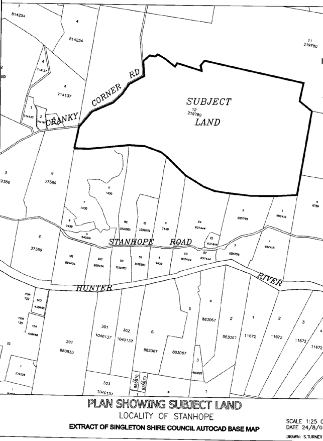
|
Attachment 2
|
Manager Planning & Development Report No. 11/04
|
|
Proposed Subdivision Plan
|
Subdivision - 14 Allotments
|
|
|
|
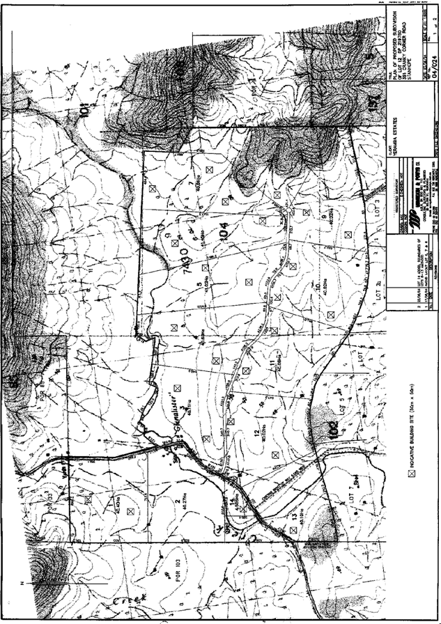
|
Attachment 3
|
Manager Planning & Development Report No. 11/04
|
|
Letter for NSW Department of Primary Industries
|
Subdivision - 14 Allotments
|
|
|
|
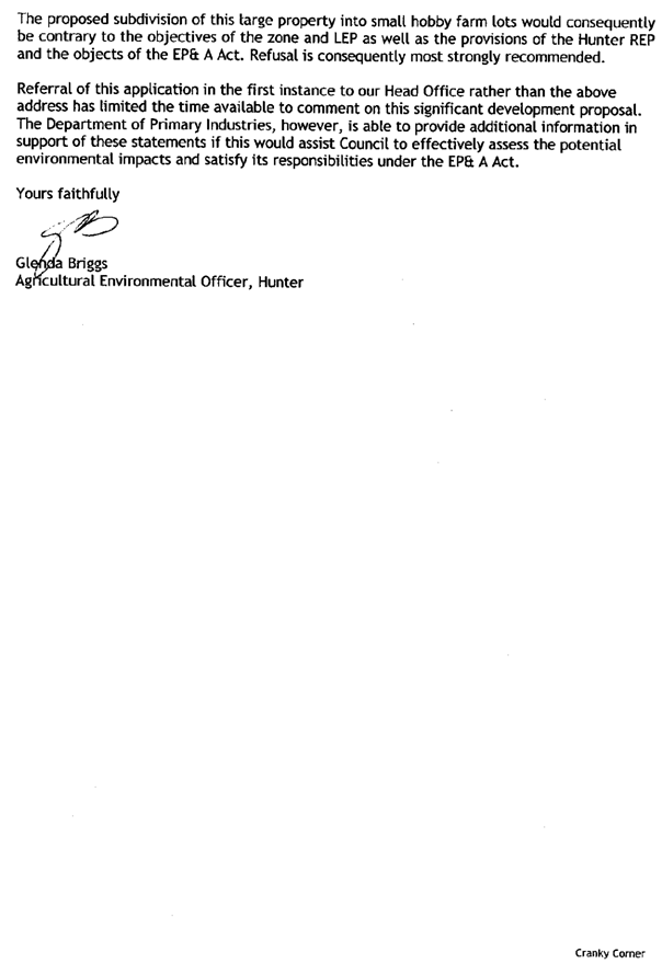
|
Attachment 4
|
Manager Planning & Development Report No. 11/04
|
|
Letter Jall Projects
|
Subdivision - 14 Allotments
|
|
|
|
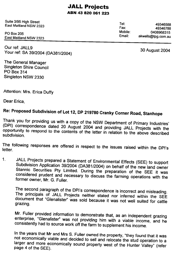
|
Attachment 5
|
Manager Planning & Development Report No. 11/04
|
|
Archaeological Risk Assessment Plan
|
Subdivision - 14 Allotments
|
|
|
|
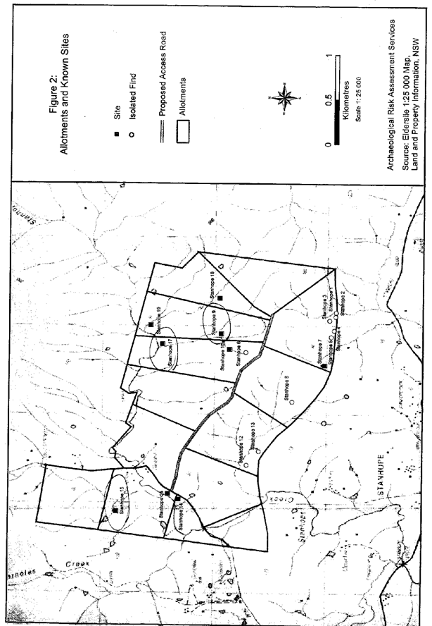
|
Attachment 6
|
Manager Planning & Development Report No. 11/04
|
|
S1 - Objection Letter
|
Subdivision - 14 Allotments
|
|
|
|
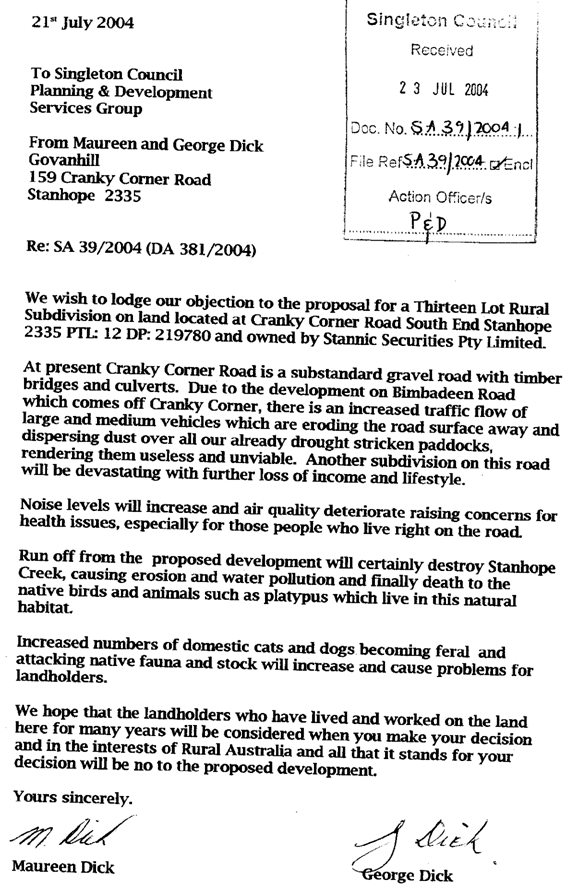
|
Attachment 7
|
Manager Planning & Development Report No. 11/04
|
|
S2 - Objection Letter
|
Subdivision - 14 Allotments
|
|
|
|
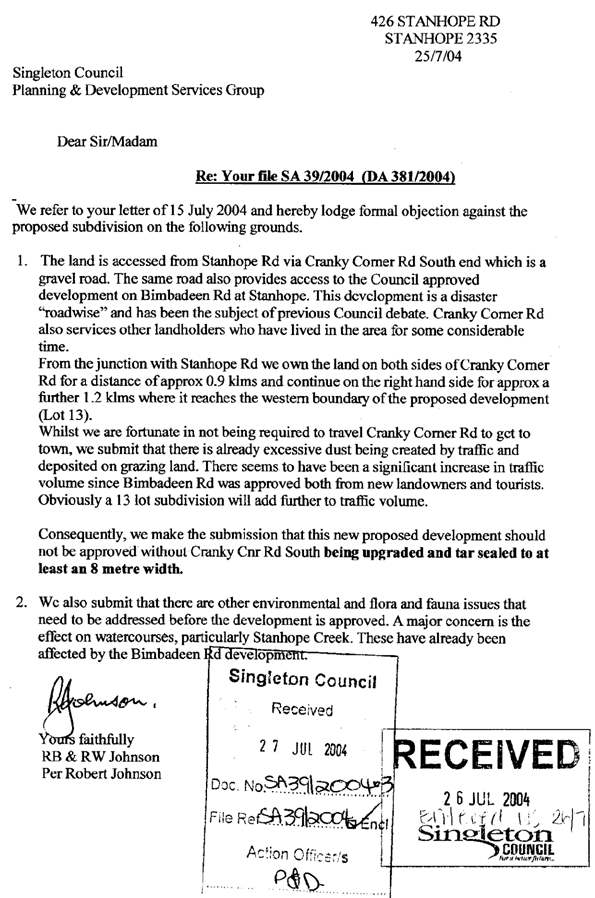
|
Attachment 8
|
Manager Planning & Development Report No. 11/04
|
|
S3 - Objection Letter
|
Subdivision - 14 Allotments
|
|
|
|
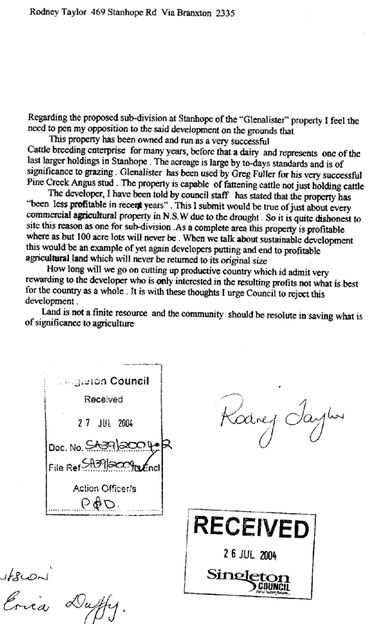
|
Attachment 9
|
Manager Planning & Development Report No. 11/04
|
|
S4 - Objection Letter
|
Subdivision - 14 Allotments
|
|
|
|
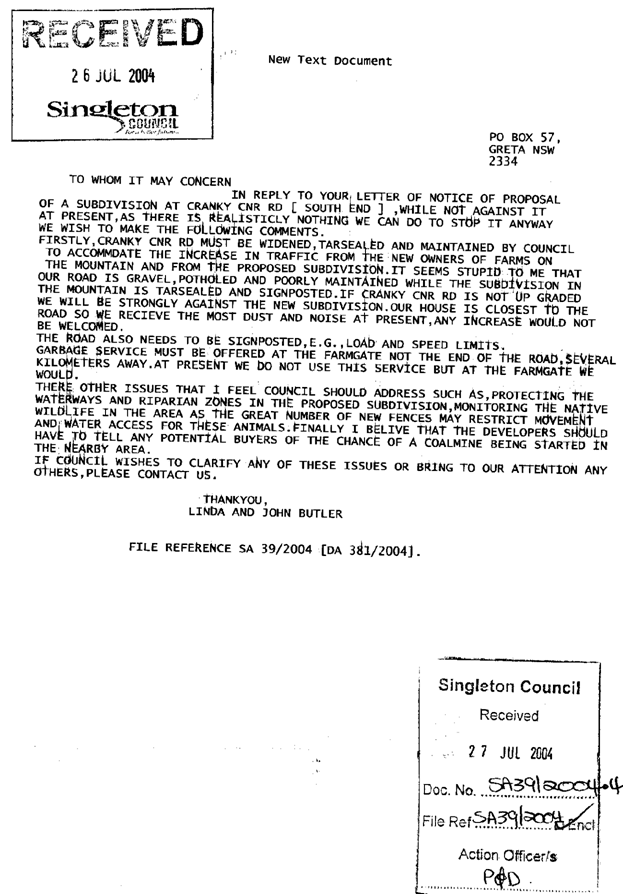
|
SINGLETON COUNCIL Minutes_Item
|
Meeting of the Corporate
and Development Services Committee - 13 September 2004
|
|
|
|
|
|
Manager
Planning & Development Report No. 10/04
|
|
|
|
|
6.
|
WATER QUALITY
MONITORING PROGRAM
Author: Brian
Thomas
|
FILE: 01/0161
|
|
Monthly
report for August 2004.
Samples are
taken from the Hunter
River, Wollombi
Brook, Glendon Brook and Black Creek each month, usually on the second
Tuesday, and analysed at the Hunter Water Laboratories at Warabrook in Newcastle.
Results of
five (5) sites are published in the Argus each month with the use of icons,
and stars to demonstrate the quality of the water on sample day. These publications are to raise community
awareness about the quality of the waterways and should be taken as an
indication only due to the fluctuations that can occur over short
periods. Stars are used to indicate
quality with good results receiving 4 stars and poor results receiving 1
star.
The
comparison information in the table below is used to determine how many
stars a particular use should receive.
Total Phosphorous is not recorded in the Argus publication.
Comparison Information for Water Quality Advertisement
|
Result Ratings
|
|
|
|
|
|
Parameter measured
|
Good ::::
|
Moderate :::
|
Fair ::
|
Poor :
|
|
Turbidity (ntu)
|
<5
|
5-25
|
25-50
|
>50
|
|
Salinity (
|
<280
|
280-800
|
800-1500
|
>1500
|
|
Faecal coliforms
(cfu/100ml)
|
Less than 150
|
n/a
|
150-1000
|
>1000
|
The report in the Argus contains icons
which are an indication of water use suitability. For example if the faecal
coliforms levels are less than 150/100ml a swimming icon will be displayed
indicating that the water was fit for swimming. If the level is 150ml or greater the icon
will not appear.
Results for
August 2004
|
Sample
Site
|
Turbidity
|
Conductivity
|
Total
Phosphorus
|
Faecal
Coliforms
|
|
Wollombi
Brook
Warkworth
|
3.4
|
1450
|
0.01
|
3
|
|
Hunter River
Moses Crossing
|
4.0
|
677
|
0.02
|
3
|
|
Hunter River
Elderslie
|
3.6
|
860
|
0.02
|
63
|
|
Glendon Brook
Mitchells Flat
|
6.8
|
1340
|
0.02
|
18
|
|
Hunter River
Singleton
|
8.6
|
766
|
0.02
|
20
|
|
Black Creek
Branxton
|
3.7
|
1640
|
0.03
|
23
|
|
|
|
FOR COUNCIL’S
INFORMATION
|
Attachments
|
AT-1
View
|
Water Quality Monitoring Program - August
|
1 page(s)
|
|
Attachment 1
|
Manager Planning & Development Report No. 11/04
|
|
Water Quality Monitoring Program - August
|
WATER QUALITY MONITORING PROGRAM
|
|
|
|
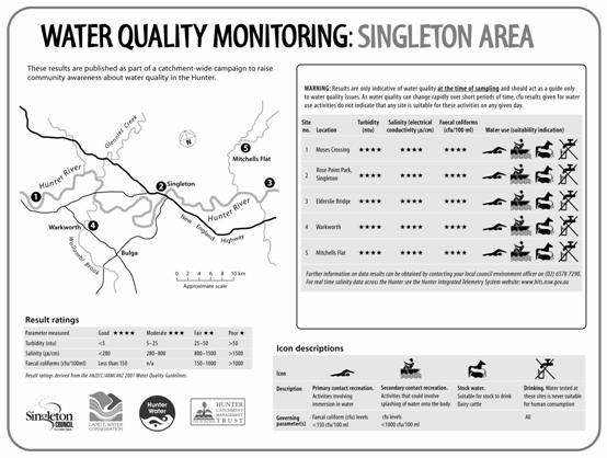
|
SINGLETON COUNCIL Minutes_Item
|
Meeting of the Corporate
and Development Services Committee - 13 September 2004
|
|
|
|
|
|
Manager
Planning & Development Report No. 10/04
|
|
|
|
|
7.
|
United Coal
Mine CCC
Author: Brian
Thomas
|
FILE: 03-0286
|
|
Executive
Summary
The Development Consent for United Coal
Mine, issued by the Minister assisting the Minister for Infrastructure &
Planning, requires the establishment of a Community Consultative
Committee. The committee will oversee
the environmental performance of the development.
Notices were placed in the Singleton
Argus and Hunter Valley News seeking nominations from the public to fill the
two community representative positions.
Council did not receive any response to these notices. The Mine then letterbox dropped the local
area resulting in nominations from Laurie Kelly of Warkworth & Helen Holz
of Jerry’s Plains.
Copies of their nomination letters are
provided to Councillors under separate cover.
Council will need to make an appointment so that the committee can be
formed.
|
|
RECOMMENDED
1. That
Council appoint Mr Kelly & Mrs Holz to represent the Community on the United
Mine Community Consultative
Committee.
2. That
Council appoint a Councillor to the position of Chairperson of the Committee.
|
Attachments
There are no attachments for this report.
Minutes_Item
|
8.
|
Minutes of
Glennies Creek Community Consultative Committee
Author: Brian
Thomas
|
FILE: 01/0282
|
A special meeting of the Glennies Creek
Colliery Community Consultative Committee was held on 16 June 2004.
The minutes of the meeting are appended to
this report as an attachment.
|
FOR COUNCIL’S
INFORMATION
|
Attachments
|
AT-1
View
|
Minutes of Glennies Creek Colliery
Community Consultative Committee Meeting
|
2 page(s)
|
|
Attachment 1
|
Manager Planning & Development Report No. 11/04
|
|
Minutes of Glennies Creek Colliery Community
Consultative Commitee Meeting
|
Minutes of Glennies Creek Community Consultative
Committee
|
|
|
|
|
SINGLETON COUNCIL Minutes_Item
|
Meeting of the Corporate
and Development Services Committee - 13 September 2004
|
|
|
|
|
|
Manager
Planning & Development Report No. 10/04
|
|
|
|
|
9.
|
Hunter Valley Operations CCC
Author: Brian
Thomas
|
FILE: 03/0047
|
The four monthly meeting of the Hunter
Valley Operations Community Consultative Committee was held on 17 June 2004. The minutes of the meeting are appended to
this report as an attachment.
|
FOR COUNCIL’S
INFORMATION
|
Attachments
|
AT-1
View
|
Minutes of Hunter Valley Operations
Community Consultative Committee meeting
|
3 page(s)
|
|
Attachment 1
|
Manager Planning & Development Report No. 11/04
|
|
Minutes of Hunter Valley Operations Community
Consultative Committee meeting
|
Hunter Valley Operations CCC
|
|
|
|
|
SINGLETON COUNCIL Minutes_Item
|
Meeting of the Corporate
and Development Services Committee - 13 September 2004
|
|
|
|
|
|
Manager
Planning & Development Report No. 10/04
|
|
|
|
|
10.
|
Camberwell
Coal Community Consultative Committee
Author: Brian
Thomas
|
FILE: 02/0063
|
The six monthly meeting of the Camberwell
Coal Mine Community Consultative Committee was held on 15 June 2004.
The minutes of the meeting are appended to
this report as an attachment.
|
FOR COUNCIL’S
INFORMATION
|
Attachments
|
AT-1
View
|
Minutes of Camberwell Coal Community
Consultative Committee Meeting
|
3 page(s)
|
|
Attachment 1
|
Manager Planning & Development Report No. 11/04
|
|
Minutes of Camberwell Coal Community Consultative
Committee Meeting
|
Camberwell Coal Community Consultative Committee
|
|
|
|
|
SINGLETON COUNCIL Minutes_Item
|
Meeting of the Corporate
and Development Services Committee - 13 September 2004
|
|
|
|
|
|
Manager
Planning & Development Report No. 10/04
|
|
|
|
|
11.
|
Minutes of
Liddell Coal Mine Community Consultative Committee Meeting
Author: Brian
Thomas
|
FILE: 02/0340
|
The six monthly meeting of the Liddell Coal
Community Consultative Committee was held on 1st June 2004. The minutes of the meeting are appended to
this report as an attachment.
|
FOR COUNCIL’S
INFORMATION
|
Attachments
|
AT-1
View
|
Minutes of Liddell Coal Mine Community
Consultative Committee Meeting
|
3 page(s)
|
|
Attachment 1
|
Manager Planning & Development Report No. 11/04
|
|
Minutes of Liddell Coal Mine Community Consultative
Committee Meeting
|
Minutes of Liddell Coal Mine Community Consultative
Committee Meeting
|
|
|
|
|
SINGLETON COUNCIL Minutes_Item
|
Meeting of the Corporate
and Development Services Committee - 13 September 2004
|
|
|
|
|
|
Manager
Planning & Development Report No. 10/04
|
|
|
|
|
12.
|
Minutes of
Ashton Coal Mine Community Consultative Committee Meeting
Author: Brian
Thomas
|
FILE: 03/0051
|
The four monthly meeting of the Ashton Mine
Community Consultative Committee was held on 29 June 2004.
The minutes of the meeting are appended to this report as an Attachment.
|
FOR COUNCIL’S
INFORMATION
|
Attachments
|
AT-1
View
|
Minutes of Ashton Coal Mine Community
Consultative Committee Meeting
|
3 page(s)
|
M Ihlein K S McMurray
Manager Planning & Development Services Director
Corporate & Development Services
|
Attachment 1
|
Manager Planning & Development Report No. 11/04
|
|
Minutes of Ashton Coal Mine Community Consultative
Committee Meeting
|
Minutes of Ashton Coal Mine Community Consultative
Committee Meeting
|
|
|
|